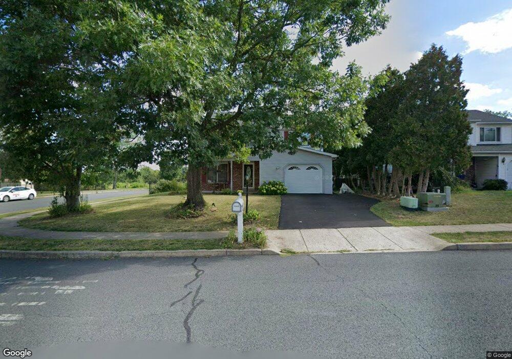
135 Sterling Dr Perkasie, PA 18944
Estimated Value: $445,000 - $492,000
3
Beds
3
Baths
1,722
Sq Ft
$270/Sq Ft
Est. Value
About This Home
This home is located at 135 Sterling Dr, Perkasie, PA 18944 and is currently estimated at $465,630, approximately $270 per square foot. 135 Sterling Dr is a home located in Bucks County with nearby schools including Pennridge High School, Souderton Charter School Collaborative, and Community Service Foundation.
Ownership History
Date
Name
Owned For
Owner Type
Purchase Details
Closed on
Aug 19, 2002
Sold by
Fuhs Thomas J and Fuhs Patricia S
Bought by
Huang Mao Rong and Huang Sokguek
Current Estimated Value
Home Financials for this Owner
Home Financials are based on the most recent Mortgage that was taken out on this home.
Original Mortgage
$124,000
Interest Rate
6%
Purchase Details
Closed on
Dec 18, 1989
Bought by
Fuhs Thomas J and Fuhs Patricia S
Create a Home Valuation Report for This Property
The Home Valuation Report is an in-depth analysis detailing your home's value as well as a comparison with similar homes in the area
Home Values in the Area
Average Home Value in this Area
Purchase History
| Date | Buyer | Sale Price | Title Company |
|---|---|---|---|
| Huang Mao Rong | $194,000 | -- | |
| Fuhs Thomas J | $152,400 | -- |
Source: Public Records
Mortgage History
| Date | Status | Borrower | Loan Amount |
|---|---|---|---|
| Closed | Huang Mao Rong | $124,000 |
Source: Public Records
Tax History Compared to Growth
Tax History
| Year | Tax Paid | Tax Assessment Tax Assessment Total Assessment is a certain percentage of the fair market value that is determined by local assessors to be the total taxable value of land and additions on the property. | Land | Improvement |
|---|---|---|---|---|
| 2025 | $5,322 | $31,040 | $5,320 | $25,720 |
| 2024 | $5,322 | $31,040 | $5,320 | $25,720 |
| 2023 | $5,260 | $31,040 | $5,320 | $25,720 |
| 2022 | $5,260 | $31,040 | $5,320 | $25,720 |
| 2021 | $5,260 | $31,040 | $5,320 | $25,720 |
| 2020 | $5,260 | $31,040 | $5,320 | $25,720 |
| 2019 | $5,229 | $31,040 | $5,320 | $25,720 |
| 2018 | $5,229 | $31,040 | $5,320 | $25,720 |
| 2017 | $5,190 | $31,040 | $5,320 | $25,720 |
| 2016 | $5,190 | $31,040 | $5,320 | $25,720 |
| 2015 | -- | $31,040 | $5,320 | $25,720 |
| 2014 | -- | $31,040 | $5,320 | $25,720 |
Source: Public Records
Map
Nearby Homes
- 2 Baldwin Way
- 0002 Baldwin Way
- 0004 Baldwin Way
- 0003 Baldwin Way
- 2550 Peachtree Dr
- 114 Orchard Rd
- 0007 Baldwin Way
- 508 Telegraph Rd
- 0009 Baldwin Way
- 0008 Baldwin Way
- 0010 Baldwin Way
- 0001 Baldwin Way
- 1 Baldwin Way
- 810 Callowhill Rd
- Building Package Callowhill Rd
- Lot Callowhill Rd
- 170 W Main St
- 420 Longleaf Dr
- 0 Callowhill Rd Unit PABU2108060
- 124 S Main St
- 133 Sterling Dr
- 201 Gentry Dr
- 131 Sterling Dr
- 137 Sterling Dr
- 1030 Deerfield Cir
- 129 Sterling Dr
- 203 Gentry Dr
- 143 Gentry Dr
- 139 Sterling Dr
- 1028 Deerfield Cir
- 127 Sterling Dr
- 101 Brighten Ct
- 140 Gentry Dr
- 1026 Deerfield Cir
- 125 Sterling Dr
- 103 Brighten Ct
- 141 Gentry Dr
- 138 Gentry Dr
- 105 Brighten Ct
- 123 Sterling Dr