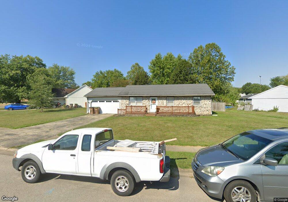
1350 Brookside Dr Columbus, IN 47201
Estimated Value: $219,000 - $242,000
3
Beds
2
Baths
1,040
Sq Ft
$218/Sq Ft
Est. Value
About This Home
This home is located at 1350 Brookside Dr, Columbus, IN 47201 and is currently estimated at $226,948, approximately $218 per square foot. 1350 Brookside Dr is a home located in Bartholomew County with nearby schools including Mount Healthy Elementary School, Central Middle School, and Columbus East High School.
Ownership History
Date
Name
Owned For
Owner Type
Purchase Details
Closed on
Mar 9, 2018
Sold by
Carrie Frederick
Bought by
Ray Penrose Steven
Current Estimated Value
Purchase Details
Closed on
Feb 2, 2004
Sold by
Waddle Jerry L and Waddle Cynthia L
Bought by
Frederick Carrie R and Furr Ryan M
Purchase Details
Closed on
Feb 21, 2001
Sold by
Huddleston Cynthia L
Bought by
Waddle Jerry and Waddle Cynthia L
Purchase Details
Closed on
Jan 30, 1998
Sold by
Eliot Ronald L and Eliot Jackie S
Bought by
Huddleston Cynthia L
Create a Home Valuation Report for This Property
The Home Valuation Report is an in-depth analysis detailing your home's value as well as a comparison with similar homes in the area
Home Values in the Area
Average Home Value in this Area
Purchase History
| Date | Buyer | Sale Price | Title Company |
|---|---|---|---|
| Ray Penrose Steven | $110,500 | -- | |
| Penrose Steven R | $110,500 | Security Title Services | |
| Frederick Carrie R | $89,900 | -- | |
| Waddle Jerry | -- | -- | |
| Huddleston Cynthia L | $78,500 | -- |
Source: Public Records
Tax History
| Year | Tax Paid | Tax Assessment Tax Assessment Total Assessment is a certain percentage of the fair market value that is determined by local assessors to be the total taxable value of land and additions on the property. | Land | Improvement |
|---|---|---|---|---|
| 2025 | $1,695 | $159,700 | $39,500 | $120,200 |
| 2024 | $1,480 | $155,200 | $39,500 | $115,700 |
| 2023 | $1,480 | $142,500 | $39,500 | $103,000 |
| 2022 | $1,465 | $136,600 | $39,500 | $97,100 |
| 2021 | $1,407 | $131,300 | $26,700 | $104,600 |
| 2020 | $1,016 | $107,100 | $18,300 | $88,800 |
| 2019 | $850 | $99,200 | $18,300 | $80,900 |
| 2018 | $789 | $97,600 | $18,300 | $79,300 |
| 2017 | $405 | $96,000 | $18,300 | $77,700 |
| 2016 | $775 | $96,400 | $18,300 | $78,100 |
| 2014 | $759 | $94,100 | $18,300 | $75,800 |
Source: Public Records
Map
Nearby Homes
- 5401 W Deaver Rd
- 3850 S 150 W
- 448 Dawson St
- 2216 Creek Bank Dr
- 2017 Shadow Creek Blvd
- 234 Lincoln St
- 1994 Shadow Creek Blvd
- 1922 Lakecrest Dr
- 2263 Shadow Bend Dr
- 2566 Creek Bank Dr
- 2363 Shadow Bend Dr
- 2621 Creek Bank Dr
- 3244 Rolling Hill Dr
- 3220 Lakestream Dr
- 3073 Creekridge Ct
- 2548 Shadow Bend Dr
- 3415 Parkview Dr
- 2542 Middle View Dr
- 2913 Creekridge Ct
- 2369 Orchard Creek Dr
- 1370 Brookside Dr
- 1340 Brookside Dr
- 1340 Brookside Dr S
- 1441 Brookside Ct N
- 1421 Brookside Ct N
- 1332 Brookside Dr
- 1371 Brookside Dr
- 1373 Brookside Dr
- 1328 Brookside Dr
- 1339 Brookside Dr
- 1383 Brookside Dr
- 18 Brookside Ct N
- 7 Brookside Ct N
- 15 Brookside Ct N
- 10 Brookside Ct N
- 11 Brookside Ct N
- 1335 Brookside Dr
- 1363 Brookside Ct S
- 1393 Brookside Dr
Your Personal Tour Guide
Ask me questions while you tour the home.