13505 W Long Point Rd Niantic Township, IL 62551
Estimated payment $9,793/month
About This Lot
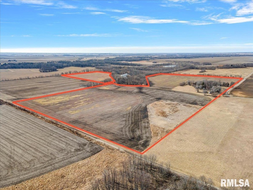
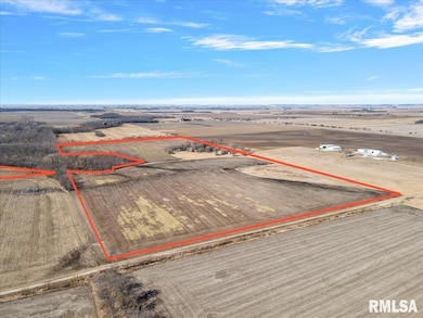
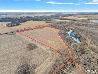
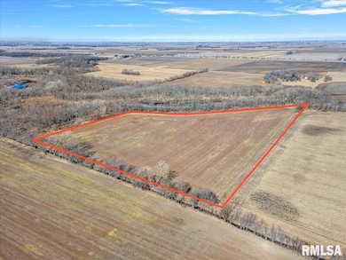
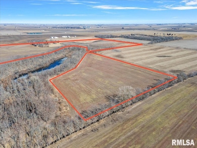
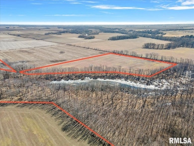
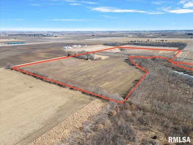
Located just South of I72, this farm ground features 3 parcels totaling 163.49 surveyed acres, 130.50 of that are tillable acres just north of the Sangamon River. Long Point Rd and Swinging Bridge Road make up the NE Corner of this farm. Soil types include Sawmill Silty Clay Loam, Huntsville Silt Loam, Tice Silty Clay Loam, Sparta Loamy Sand, Wabash Silt Clay, Proctor Silt Loam, Broadwell Silt Loam and Elburn Silt Loam. Surveyed 2025.
Listing Agent
The Real Estate Group, Inc. Brokerage Phone: 217-891-2490 License #475176529 Listed on: 02/21/2025

Co-Listing Agent
The Real Estate Group, Inc. Brokerage Phone: 217-891-2490 License #475124311
Property Details
Property Type
- Land
Est. Annual Taxes
- $7,423
Schools
- Sangamon Valley High School
Farming
- Agricultural
Utilities
- Water Not Available
- Sewer Not Available
Community Details
- No Home Owners Association
Listing and Financial Details
- Assessor Parcel Number 131022200003
Map
Home Values in the Area
Average Home Value in this Area
Tax History
| Year | Tax Paid | Tax Assessment Tax Assessment Total Assessment is a certain percentage of the fair market value that is determined by local assessors to be the total taxable value of land and additions on the property. | Land | Improvement |
|---|---|---|---|---|
| 2024 | $4,878 | $61,253 | $59,333 | $1,920 |
| 2023 | $4,467 | $57,152 | $55,234 | $1,918 |
| 2022 | $4,306 | $53,150 | $51,236 | $1,914 |
| 2021 | $4,139 | $49,645 | $47,734 | $1,911 |
| 2020 | $3,696 | $43,782 | $41,924 | $1,858 |
| 2019 | $3,696 | $43,782 | $41,924 | $1,858 |
| 2018 | $3,429 | $40,521 | $38,663 | $1,858 |
| 2017 | $3,319 | $38,534 | $36,676 | $1,858 |
| 2016 | $3,196 | $36,677 | $34,819 | $1,858 |
| 2015 | $2,996 | $34,825 | $32,967 | $1,858 |
| 2014 | $2,813 | $33,609 | $31,751 | $1,858 |
| 2013 | $2,835 | $31,197 | $29,339 | $1,858 |
Property History
| Date | Event | Price | List to Sale | Price per Sq Ft |
|---|---|---|---|---|
| 10/30/2025 10/30/25 | Price Changed | $1,749,343 | -4.5% | -- |
| 02/21/2025 02/21/25 | For Sale | $1,831,950 | -- | -- |
Source: RMLS Alliance
MLS Number: CA1034568
APN: 13-10-22-200-003
Disclaimer: Certain information contained herein is derived from information provided by parties other than Homes.com. All information provided is deemed reliable, but is not guaranteed to be accurate and should be independently verified.
![]() IDX information is provided exclusively for personal, non-commercial use, and may not be used for any purpose other than to identify prospective properties consumers may be interested in purchasing. Information is deemed reliable but not guaranteed.
IDX information is provided exclusively for personal, non-commercial use, and may not be used for any purpose other than to identify prospective properties consumers may be interested in purchasing. Information is deemed reliable but not guaranteed.
- 120 8th St Unit 1
- 709 Louisa St
- 420 6th St
- 414 5th St
- 360 N Main St
- 116 N Moore St Unit 1
- 1359 S Bridge Rd
- 113 Prairie Run
- 0 Bill Wall Dr
- 116 E Center St
- 1955 E 2700 Rd N
- 275 N Camp St
- 7625 W William St
- 0 W Wood St
- 0 W Harristown Blvd Unit 6251050
- 3247 Nevada Rd
- 3335 Nevada Rd
- 5595 W Main St
- Mosquito Creek Rd
- 5180 W Cantrell St
- 2474 N Florian Ave
- 1160 N Summit Ave
- 1405 W Wood St
- 1174 W King St
- 3707 N Northhaven Ct
- 1076 W Main St
- 1061 W Decatur St
- 1852 N Gulick Ave
- 917 W King St
- 816 W William St
- 701 W Grand Ave
- 1505 N Monroe St
- 1691 N Edward St Unit 3
- 552 S Church St
- 1035 S Main St
- 185 W Imboden Dr Unit Studio
- 185 W Imboden Dr Unit 1-BR
- 2150 S Imboden Place
- 327 E Stuart Ave
- 2248 N Water St