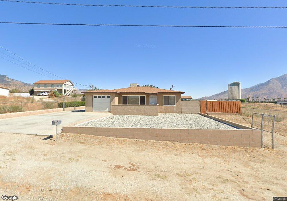
13513 Apache Trail Cabazon, CA 92230
Estimated Value: $250,000 - $428,000
3
Beds
1
Bath
1,123
Sq Ft
$308/Sq Ft
Est. Value
About This Home
This home is located at 13513 Apache Trail, Cabazon, CA 92230 and is currently estimated at $345,570, approximately $307 per square foot. 13513 Apache Trail is a home located in Riverside County with nearby schools including Banning High School.
Ownership History
Date
Name
Owned For
Owner Type
Purchase Details
Closed on
Nov 18, 2022
Sold by
Lopez Leandro J
Bought by
Lopez Leandro J and Velasquez Michelle F
Current Estimated Value
Purchase Details
Closed on
Aug 5, 1994
Sold by
Collins George R and Collins Renee C
Bought by
Lopez Leandro J
Home Financials for this Owner
Home Financials are based on the most recent Mortgage that was taken out on this home.
Original Mortgage
$48,450
Interest Rate
8.58%
Mortgage Type
FHA
Create a Home Valuation Report for This Property
The Home Valuation Report is an in-depth analysis detailing your home's value as well as a comparison with similar homes in the area
Home Values in the Area
Average Home Value in this Area
Purchase History
| Date | Buyer | Sale Price | Title Company |
|---|---|---|---|
| Lopez Leandro J | -- | -- | |
| Lopez Leandro J | $57,500 | Gateway Title Company |
Source: Public Records
Mortgage History
| Date | Status | Borrower | Loan Amount |
|---|---|---|---|
| Previous Owner | Lopez Leandro J | $48,450 |
Source: Public Records
Tax History
| Year | Tax Paid | Tax Assessment Tax Assessment Total Assessment is a certain percentage of the fair market value that is determined by local assessors to be the total taxable value of land and additions on the property. | Land | Improvement |
|---|---|---|---|---|
| 2025 | $1,339 | $94,014 | $16,772 | $77,242 |
| 2023 | $1,339 | $90,366 | $16,123 | $74,243 |
| 2022 | $1,312 | $88,595 | $15,807 | $72,788 |
| 2021 | $1,288 | $86,859 | $15,498 | $71,361 |
| 2020 | $1,275 | $85,970 | $15,340 | $70,630 |
| 2019 | $1,255 | $84,286 | $15,040 | $69,246 |
| 2018 | $1,247 | $82,635 | $14,746 | $67,889 |
| 2017 | $1,226 | $81,015 | $14,457 | $66,558 |
| 2016 | $1,167 | $79,427 | $14,174 | $65,253 |
| 2015 | $1,151 | $78,236 | $13,962 | $64,274 |
| 2014 | $1,144 | $76,706 | $13,690 | $63,016 |
Source: Public Records
Map
Nearby Homes
- 0 Bonita Ave Unit 26639551
- 49349 Blanche Ave
- 0 Aloma Dr Unit IV25239532
- 0 Aloma Dr Unit IV23231315
- 0 Faryl Ave Unit OC25198467
- 0 Faryl Ave Unit IV26019283
- 0 Faryl Ave Unit JT25276974
- 0 Faryl Ave Unit DW25170317
- 0 Faryl Ave Unit IV26019292
- 0 Faryl Ave Unit 10
- 50292 Ramona St
- 49901 Mountain View Ave
- 14140 Broadway (Vicinity) St
- 50222 Aloma Dr
- 0 Jacueline Unit DW24086825
- 0 Jacueline Unit SW25176451
- 0 Na Unit EV23021645
- 14290 Rafael St
- 1368 Cedarwood Dr
- 5477 Indigo Way
- 13525 Apache Trail
- 13539 Apache Trail
- 13487 Apache Trail
- 13473 Apache Trail
- 13551 Apache Trail
- 13565 Apache Trail
- 13461 Apache Trail
- 48923 Taos Rd
- 13451 Apache Trail
- 48899 Taos Rd
- 48878 Mojave Dr
- 13424 Apache Trail
- 13425 Apache Trail
- 48891 Taos Rd
- 48870 Taos Rd
- 0 Mojave Rd Unit I08094677
- 48834 Mojave Dr
- 48885 Taos Rd
- 13390 Apache Trail
- 48875 Taos Rd
Your Personal Tour Guide
Ask me questions while you tour the home.