Estimated Value: $948,058 - $1,051,000
4
Beds
2
Baths
1,520
Sq Ft
$663/Sq Ft
Est. Value
About This Home
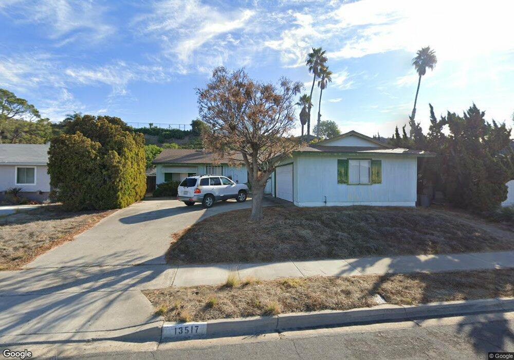
This home is located at 13517 Tobiasson Rd, Poway, CA 92064 and is currently estimated at $1,008,515, approximately $663 per square foot. 13517 Tobiasson Rd is a home located in San Diego County with nearby schools including Pomerado Elementary, Meadowbrook Middle, and Poway High.
Ownership History
Date
Name
Owned For
Owner Type
Purchase Details
Closed on
Mar 23, 2018
Sold by
Thompson Barbara
Bought by
Thompson Barbara and Barbara E Thompson Trust
Current Estimated Value
Purchase Details
Closed on
Mar 16, 2004
Sold by
Thompson Walter B and Thompson Barbara
Bought by
Thompson Walter B and Thompson Barbara E
Home Financials for this Owner
Home Financials are based on the most recent Mortgage that was taken out on this home.
Original Mortgage
$318,000
Interest Rate
5.69%
Mortgage Type
New Conventional
Create a Home Valuation Report for This Property
The Home Valuation Report is an in-depth analysis detailing your home's value as well as a comparison with similar homes in the area
Home Values in the Area
Average Home Value in this Area
Purchase History
We collect this data history from publicly available records. To have your information removed, we recommend requesting removal directly through your county’s website.
| Date | Buyer | Sale Price | Title Company |
|---|---|---|---|
| Thompson Barbara | -- | None Available | |
| Thompson Walter B | -- | Southland Title Of San Diego |
Source: Public Records
Mortgage History
We collect this data history from publicly available records. To have your information removed, we recommend requesting removal directly through your county’s website.
| Date | Status | Borrower | Loan Amount |
|---|---|---|---|
| Previous Owner | Thompson Walter B | $318,000 |
Source: Public Records
Tax History
| Year | Tax Paid | Tax Assessment Tax Assessment Total Assessment is a certain percentage of the fair market value that is determined by local assessors to be the total taxable value of land and additions on the property. | Land | Improvement |
|---|---|---|---|---|
| 2025 | $1,802 | $161,893 | $56,598 | $105,295 |
| 2024 | $1,802 | $158,720 | $55,489 | $103,231 |
| 2023 | $1,763 | $155,608 | $54,401 | $101,207 |
| 2022 | $1,733 | $152,558 | $53,335 | $99,223 |
| 2021 | $1,710 | $149,568 | $52,290 | $97,278 |
| 2020 | $1,688 | $148,035 | $51,754 | $96,281 |
| 2019 | $1,645 | $145,134 | $50,740 | $94,394 |
| 2018 | $1,599 | $142,290 | $49,746 | $92,544 |
| 2017 | $1,556 | $139,501 | $48,771 | $90,730 |
| 2016 | $1,523 | $136,766 | $47,815 | $88,951 |
| 2015 | $1,501 | $134,712 | $47,097 | $87,615 |
| 2014 | $1,467 | $132,074 | $46,175 | $85,899 |
Source: Public Records
Map
Nearby Homes
- 12609 Robison Blvd Unit 106
- 13254 Powers Ct
- 13148 Ridgedale Dr
- 12745 Robison Blvd Unit 18
- 13757 Eisenhower Ave
- 13824 Powers Rd
- 12862 Carriage Heights Way
- 12875 Carriage Heights Way Unit 12875
- 12717 Harmon Rd
- 13515 Essence Rd
- 12934 Slack St
- 12696 Harmon Rd
- 12953 Carriage Rd
- 12957 Ilene St
- 13050 Tuscarora Dr
- 12838 Montauk St
- 1/2 Poway Rd
- 13085 Olympus Cir Unit 1
- 13068 Olympus Cir Unit 1
- 13056 Poway Rd
- 13440 Tobiasson Rd
- 13434 Tobiasson Rd
- 13502 Tobiasson Rd
- 13428 Tobiasson Rd
- 13508 Tobiasson Rd
- 13445 Frame Rd
- 13439 Frame Rd
- 13505 Frame Rd
- 13433 Frame Rd
- 13514 Tobiasson Rd
- 13422 Tobiasson Rd
- 13441 Tobiasson Rd
- 13435 Tobiasson Rd
- 13511 Frame Rd
- 13505 Tobiasson Rd
- 13429 Tobiasson Rd
- 13427 Frame Rd
- 13520 Tobiasson Rd
- 13511 Tobiasson Rd
- 13517 Frame Rd
Your Personal Tour Guide
Ask me questions while you tour the home.