Estimated Value: $925,488 - $1,050,000
3
Beds
2
Baths
1,448
Sq Ft
$688/Sq Ft
Est. Value
About This Home
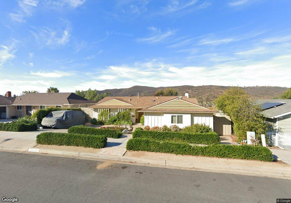
This home is located at 13526 Tobiasson Rd, Poway, CA 92064 and is currently estimated at $995,622, approximately $687 per square foot. 13526 Tobiasson Rd is a home located in San Diego County with nearby schools including Pomerado Elementary, Meadowbrook Middle, and Poway High.
Ownership History
Date
Name
Owned For
Owner Type
Purchase Details
Closed on
Dec 4, 2002
Sold by
Ryden David M and Ryden Janet L
Bought by
Ryden David M and Ryden Janet L
Current Estimated Value
Home Financials for this Owner
Home Financials are based on the most recent Mortgage that was taken out on this home.
Original Mortgage
$246,000
Interest Rate
6.28%
Purchase Details
Closed on
Apr 18, 2002
Sold by
Ryden David M and Ryden Janet L
Bought by
Ryden David M and Ryden Janet L
Purchase Details
Closed on
Oct 7, 1988
Purchase Details
Closed on
Jan 29, 1987
Create a Home Valuation Report for This Property
The Home Valuation Report is an in-depth analysis detailing your home's value as well as a comparison with similar homes in the area
Home Values in the Area
Average Home Value in this Area
Purchase History
| Date | Buyer | Sale Price | Title Company |
|---|---|---|---|
| Ryden David M | -- | Chicago Title Co | |
| Ryden David M | -- | -- | |
| -- | $135,000 | -- | |
| -- | $115,900 | -- |
Source: Public Records
Mortgage History
| Date | Status | Borrower | Loan Amount |
|---|---|---|---|
| Closed | Ryden David M | $246,000 |
Source: Public Records
Tax History
| Year | Tax Paid | Tax Assessment Tax Assessment Total Assessment is a certain percentage of the fair market value that is determined by local assessors to be the total taxable value of land and additions on the property. | Land | Improvement |
|---|---|---|---|---|
| 2025 | $3,310 | $299,178 | $84,419 | $214,759 |
| 2024 | $3,310 | $293,313 | $82,764 | $210,549 |
| 2023 | $3,239 | $287,563 | $81,142 | $206,421 |
| 2022 | $3,185 | $281,925 | $79,551 | $202,374 |
| 2021 | $3,143 | $276,398 | $77,992 | $198,406 |
| 2020 | $3,101 | $273,565 | $77,193 | $196,372 |
| 2019 | $3,021 | $268,202 | $75,680 | $192,522 |
| 2018 | $2,936 | $262,945 | $74,197 | $188,748 |
| 2017 | $2,792 | $251,791 | $72,743 | $179,048 |
| 2016 | $2,540 | $229,208 | $71,317 | $157,891 |
| 2015 | $2,502 | $225,766 | $70,246 | $155,520 |
| 2014 | $2,360 | $206,638 | $68,870 | $137,768 |
Source: Public Records
Map
Nearby Homes
- 13442 Mountainside Dr
- 12450 Robison Blvd
- 12643 Robison Blvd Unit 213
- 12739 Papago Dr
- 13824 Powers Rd
- 12719 Robison Blvd Unit 18
- 13622 Utopia Rd
- 13641 Carriage Rd
- 12445 Witt Place
- 12939 Cree Ct
- 12311 Witt Rd
- 12953 Carriage Rd
- 12665 Oak Knoll Rd
- 12701 Oak Knoll Rd
- 12709 Oak Knoll Rd
- 1/2 Poway Rd
- 13056 Poway Rd
- 13085 Olympus Cir
- 13087 Olympus Cir Unit 2
- 13483 Pequot Dr
- 13520 Tobiasson Rd
- 13532 Tobiasson Rd
- 13514 Tobiasson Rd
- 13538 Tobiasson Rd
- 13523 Frame Rd
- 13529 Frame Rd
- 13517 Frame Rd
- 13535 Frame Rd
- 13508 Tobiasson Rd
- 13610 Tobiasson Rd
- 13523 Tobiasson Rd
- 13529 Tobiasson Rd
- 13511 Frame Rd
- 13517 Tobiasson Rd
- 13535 Tobiasson Rd
- 13609 Frame Rd
- 13511 Tobiasson Rd
- 13502 Tobiasson Rd
- 13616 Tobiasson Rd
- 13505 Frame Rd
Your Personal Tour Guide
Ask me questions while you tour the home.