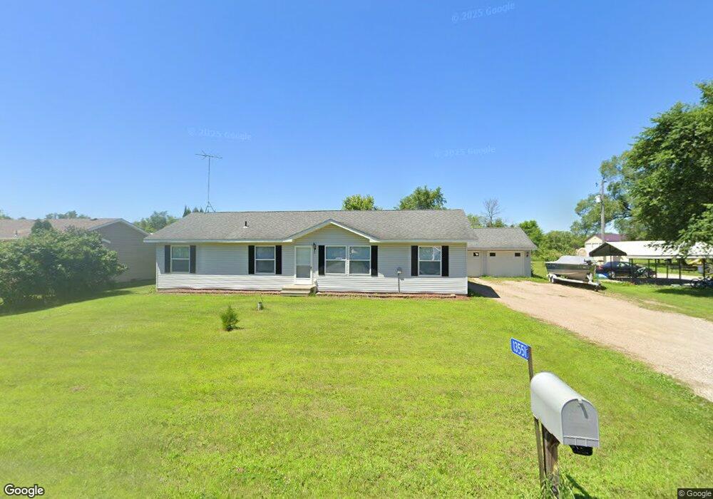
13551 51st Ave South Haven, MN 55382
Estimated Value: $280,000 - $304,000
3
Beds
2
Baths
1,568
Sq Ft
$187/Sq Ft
Est. Value
About This Home
This home is located at 13551 51st Ave, South Haven, MN 55382 and is currently estimated at $293,645, approximately $187 per square foot. 13551 51st Ave is a home located in Stearns County with nearby schools including Kimball Elementary School and Kimball High School.
Ownership History
Date
Name
Owned For
Owner Type
Purchase Details
Closed on
Oct 20, 2021
Sold by
Dobis Jonathan P and Dobis Tammy L
Bought by
Dobis Jonathan P and Dobis Tammy L
Current Estimated Value
Purchase Details
Closed on
Oct 11, 2021
Sold by
Dobis Jason and Dobis Terrell
Bought by
Dobis Jonathan P
Purchase Details
Closed on
Sep 20, 2021
Sold by
Mattson Jill M and Mattson Jason
Bought by
Dobis Jonathan P
Purchase Details
Closed on
Nov 19, 2004
Sold by
Greenfield Homes Inc
Bought by
Dobis Jonathan Etal
Purchase Details
Closed on
Mar 19, 2003
Sold by
Rose Donald
Bought by
Greenfield Homes Inc
Purchase Details
Closed on
Jul 20, 2000
Sold by
Gutknecht Ervin
Bought by
Rose Donald
Create a Home Valuation Report for This Property
The Home Valuation Report is an in-depth analysis detailing your home's value as well as a comparison with similar homes in the area
Home Values in the Area
Average Home Value in this Area
Purchase History
| Date | Buyer | Sale Price | Title Company |
|---|---|---|---|
| Dobis Jonathan P | -- | None Available | |
| Dobis Jonathan P | -- | None Available | |
| Dobis Jonathan P | -- | None Available | |
| Mattson Jill M | -- | None Available | |
| Dobis Jonathan Etal | $36,000 | -- | |
| Greenfield Homes Inc | $60,000 | -- | |
| Rose Donald | $18,300 | -- |
Source: Public Records
Tax History Compared to Growth
Tax History
| Year | Tax Paid | Tax Assessment Tax Assessment Total Assessment is a certain percentage of the fair market value that is determined by local assessors to be the total taxable value of land and additions on the property. | Land | Improvement |
|---|---|---|---|---|
| 2025 | $2,352 | $277,100 | $53,600 | $223,500 |
| 2024 | $2,352 | $275,100 | $53,600 | $221,500 |
| 2023 | $2,274 | $271,200 | $53,600 | $217,600 |
| 2022 | $2,124 | $205,100 | $49,800 | $155,300 |
| 2021 | $2,248 | $205,100 | $49,800 | $155,300 |
| 2020 | $1,986 | $203,100 | $49,800 | $153,300 |
| 2019 | $1,856 | $178,900 | $27,700 | $151,200 |
| 2018 | $1,690 | $146,200 | $22,100 | $124,100 |
Source: Public Records
Map
Nearby Homes
- 10848 Porter Ave NW
- 14XXX County Road 44
- 16698 109th St NW
- 10368 Oliver Ave NW
- 10399 Reardon Ave NW
- 13943 102nd St NW
- 13934 101st St NW
- 8537 Pittman Ave NW
- 13496 Campfire Cir
- 2060 Clearwater Forest Dr
- South Tract A TBD County Road 45
- North Tract B TBD County Road 45
- 125 Cedar St SE
- 148 Cedar St SE
- 118 Cedar St SE
- 847 Walnut Ave SE
- 0 80th St NW
- 226 Quill St NE
- 451 Linden Ave E
- 351 Publishers Dr NE
- 13533 51st Ave
- 13572 51st Ave
- 13529 51st Ave
- 5045 136th St
- 5054 136th St
- 13503 51st Ave
- 13557 50th Ave
- 13527 50th Ave
- 5012 135th St
- 13601 50th Ave
- 5135 County Road 44
- 13458 51st Ave
- 5164 135th St
- 13631 50th Ave
- 5133 135th St
- 4991 136th St
- 4984 136th St
- 51XX Bluewater Cir
- 5052 County Road 44
- 5028 County Road 44