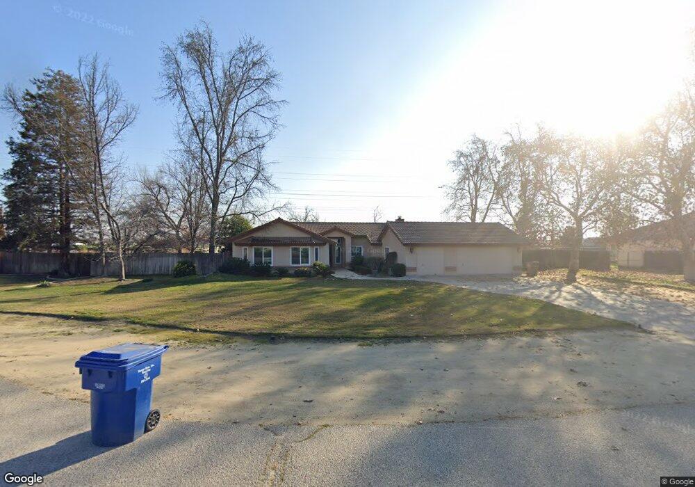
13559 Mausbach Ave Bakersfield, CA 93314
Estimated Value: $420,000 - $605,000
3
Beds
2
Baths
2,027
Sq Ft
$255/Sq Ft
Est. Value
About This Home
This home is located at 13559 Mausbach Ave, Bakersfield, CA 93314 and is currently estimated at $516,672, approximately $254 per square foot. 13559 Mausbach Ave is a home located in Kern County with nearby schools including Independence Elementary School, Freedom Middle School, and Frontier High School.
Ownership History
Date
Name
Owned For
Owner Type
Purchase Details
Closed on
Jan 18, 2022
Sold by
Wallick Cynthia H
Bought by
Cynthia H Wallick Family Trust
Current Estimated Value
Purchase Details
Closed on
May 20, 2002
Sold by
Ward Michael J and Ward Marilou
Bought by
Wallick James S and Wallick Cynthia H
Home Financials for this Owner
Home Financials are based on the most recent Mortgage that was taken out on this home.
Original Mortgage
$205,600
Interest Rate
6.89%
Purchase Details
Closed on
Aug 11, 1995
Sold by
Ward Michael J and Ward Marilou
Bought by
Ward Michael J and Ward Marilou
Home Financials for this Owner
Home Financials are based on the most recent Mortgage that was taken out on this home.
Original Mortgage
$25,000
Interest Rate
7.63%
Create a Home Valuation Report for This Property
The Home Valuation Report is an in-depth analysis detailing your home's value as well as a comparison with similar homes in the area
Home Values in the Area
Average Home Value in this Area
Purchase History
| Date | Buyer | Sale Price | Title Company |
|---|---|---|---|
| Cynthia H Wallick Family Trust | -- | None Listed On Document | |
| Wallick James S | $257,000 | First American Title Co | |
| Ward Michael J | -- | -- |
Source: Public Records
Mortgage History
| Date | Status | Borrower | Loan Amount |
|---|---|---|---|
| Previous Owner | Wallick James S | $205,600 | |
| Previous Owner | Ward Michael J | $25,000 |
Source: Public Records
Tax History
| Year | Tax Paid | Tax Assessment Tax Assessment Total Assessment is a certain percentage of the fair market value that is determined by local assessors to be the total taxable value of land and additions on the property. | Land | Improvement |
|---|---|---|---|---|
| 2025 | $4,755 | $379,645 | $73,854 | $305,791 |
| 2024 | $4,634 | $372,202 | $72,406 | $299,796 |
| 2023 | $4,634 | $364,905 | $70,987 | $293,918 |
| 2022 | $4,530 | $357,751 | $69,596 | $288,155 |
| 2021 | $4,389 | $350,737 | $68,232 | $282,505 |
| 2020 | $4,389 | $347,142 | $67,533 | $279,609 |
| 2019 | $4,205 | $347,142 | $67,533 | $279,609 |
| 2018 | $4,091 | $333,663 | $64,911 | $268,752 |
| 2017 | $4,010 | $327,122 | $63,639 | $263,483 |
| 2016 | $3,763 | $320,709 | $62,392 | $258,317 |
| 2015 | $3,552 | $303,000 | $76,000 | $227,000 |
| 2014 | $3,546 | $304,000 | $76,000 | $228,000 |
Source: Public Records
Map
Nearby Homes
- 13201 Meacham Rd
- 13615 Velma Pearl Way
- 13544 Velma Pearl Way
- 13507 Velma Pearl Way
- 13303 Ascot Ct
- 13601 Philip Phelps Ave
- 13602 Philip Phelps Ave
- 13620 Philip Phelps Ave
- 13013 Tyler Ct
- 13547 Philip Phelps Ave
- 12912 Tyler Ct
- 3000 Allen Rd
- 13418 Giro Dr
- 14035 Rosedale Hwy Unit 72
- 14035 Rosedale Hwy Unit 93
- 14035 Rosedale Hwy Unit 82
- 14035 Rosedale Hwy Unit 134
- 14035 Rosedale Hwy Unit 108
- 14035 Rosedale Hwy Unit 69
- 14035 Rosedale Hwy Unit 66
- 13503 Mausbach Ave
- 13605 Mausbach Ave
- 13600 Mausbach Ave
- 13639 Mausbach Ave
- 13440 Pergola Ave
- 13421 Pergola Ave
- 13500 Mausbach Ave
- 13420 Pergola Ave
- 13558 Mausbach Ave
- 13441 Conservatory Ct
- 13401 Pergola Ave
- 13421 Conservatory Ct
- 3256 Jenkins Rd
- 3045 Jenkins Rd
- 13341 Pergola Ave
- 3011 Jenkins Rd
- 13401 Conservatory Ct
- 3111 Jenkins Rd
- 13340 Pergola Ave
- 13549 Morales Ct
Your Personal Tour Guide
Ask me questions while you tour the home.