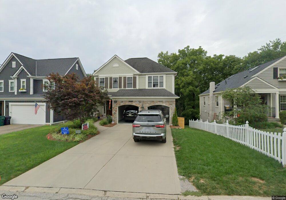
1359 Custer Ave Cincinnati, OH 45208
Mount Lookout NeighborhoodEstimated Value: $1,266,000 - $1,533,000
3
Beds
3
Baths
4,161
Sq Ft
$332/Sq Ft
Est. Value
About This Home
This home is located at 1359 Custer Ave, Cincinnati, OH 45208 and is currently estimated at $1,382,877, approximately $332 per square foot. 1359 Custer Ave is a home located in Hamilton County with nearby schools including Kilgour Elementary School, Clark Montessori High School, and Shroder High School.
Ownership History
Date
Name
Owned For
Owner Type
Purchase Details
Closed on
Apr 29, 2005
Sold by
Anness Harold L
Bought by
Desmond John T and Blum Katherine D
Current Estimated Value
Home Financials for this Owner
Home Financials are based on the most recent Mortgage that was taken out on this home.
Original Mortgage
$600,000
Interest Rate
6.13%
Mortgage Type
Unknown
Purchase Details
Closed on
Aug 27, 1997
Sold by
Christman Ellen J
Bought by
Ramsey Hill Corp
Create a Home Valuation Report for This Property
The Home Valuation Report is an in-depth analysis detailing your home's value as well as a comparison with similar homes in the area
Home Values in the Area
Average Home Value in this Area
Purchase History
| Date | Buyer | Sale Price | Title Company |
|---|---|---|---|
| Desmond John T | -- | None Available | |
| Anness Harold L | $725,100 | None Available | |
| Ramsey Hill Corp | $68,200 | -- | |
| Ramsey Hill Corp | $166,900 | -- |
Source: Public Records
Mortgage History
| Date | Status | Borrower | Loan Amount |
|---|---|---|---|
| Previous Owner | Desmond John T | $600,000 |
Source: Public Records
Tax History
| Year | Tax Paid | Tax Assessment Tax Assessment Total Assessment is a certain percentage of the fair market value that is determined by local assessors to be the total taxable value of land and additions on the property. | Land | Improvement |
|---|---|---|---|---|
| 2025 | $20,086 | $326,669 | $78,988 | $247,681 |
| 2024 | $19,475 | $326,669 | $78,988 | $247,681 |
| 2023 | $18,600 | $305,053 | $78,988 | $226,065 |
| 2022 | $19,564 | $287,851 | $69,713 | $218,138 |
| 2021 | $18,838 | $287,851 | $69,713 | $218,138 |
| 2020 | $19,392 | $287,851 | $69,713 | $218,138 |
| 2019 | $18,117 | $246,026 | $59,584 | $186,442 |
| 2018 | $18,145 | $246,026 | $59,584 | $186,442 |
| 2017 | $17,238 | $246,026 | $59,584 | $186,442 |
| 2016 | $16,565 | $233,100 | $56,021 | $177,079 |
| 2015 | $9,717 | $233,100 | $56,021 | $177,079 |
| 2014 | $9,786 | $233,100 | $56,021 | $177,079 |
| 2013 | $8,972 | $210,000 | $50,470 | $159,530 |
Source: Public Records
Map
Nearby Homes
- 3443 Ault View Ave
- 1338 Suncrest Dr
- 3635 Ault Park Ave
- 1344 Delta Ave
- 3508 Tarpis Ave
- 3613 Herschel Ave
- 3509 Tarpis Ave
- 3517 Tarpis Ave
- 1225 Corbett St
- 1134 Beverly Hill Dr
- 3649 Herschel Ave
- 5112 Shattuc Ave
- 1065 Delta Ave
- 3059 Griest Ave
- 5087 Bouchaine Way
- 3037 Griest Ave
- 3645 Russell Ave
- 3646 Ashworth Dr
- 3300 Linwood Ave
- 3008 Erie Ave
- 1355 Custer Ave
- 1363 Custer Ave
- 1351 Custer Ave
- 1365 Custer Ave
- 1349 Custer Ave
- 3380 Ault View Ave
- 3384 Ault View Ave
- 1369 Custer Ave
- 1347 Custer Ave
- 3376 Ault View Ave
- 3386 Ault View Ave
- 1356 Custer Ave
- 1352 Custer Ave
- 1334 Ault View Ave
- 1360 Custer Ave
- 3388 Ault View Ave
- 3389 Custer Ave
- 3400 Ault View Ave
- 1345 Custer Ave
- 3406 Ault View Ave
Your Personal Tour Guide
Ask me questions while you tour the home.