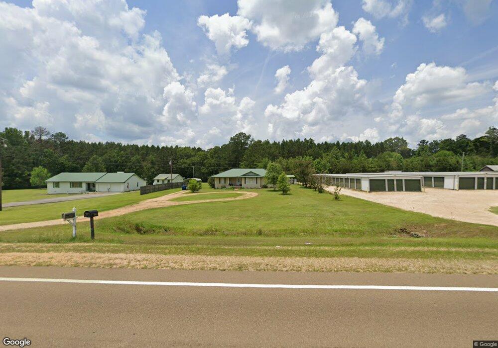
1359 U S 51 Brookhaven, MS 39601
Estimated Value: $140,819 - $188,000
3
Beds
2
Baths
1,433
Sq Ft
$115/Sq Ft
Est. Value
About This Home
This home is located at 1359 U S 51, Brookhaven, MS 39601 and is currently estimated at $165,205, approximately $115 per square foot. 1359 U S 51 is a home located in Lincoln County with nearby schools including Brookhaven High School and Faith Presbyterian Kindergarten.
Ownership History
Date
Name
Owned For
Owner Type
Purchase Details
Closed on
Jul 28, 2020
Sold by
Thompson Kevin B
Bought by
Simmons William Lane
Current Estimated Value
Home Financials for this Owner
Home Financials are based on the most recent Mortgage that was taken out on this home.
Original Mortgage
$117,070
Outstanding Balance
$102,879
Interest Rate
3.1%
Mortgage Type
New Conventional
Estimated Equity
$62,326
Purchase Details
Closed on
Apr 26, 2010
Sold by
Butler Joe E and Butler Ellen S
Bought by
Thompson Kevin B
Home Financials for this Owner
Home Financials are based on the most recent Mortgage that was taken out on this home.
Original Mortgage
$94,261
Interest Rate
4.94%
Create a Home Valuation Report for This Property
The Home Valuation Report is an in-depth analysis detailing your home's value as well as a comparison with similar homes in the area
Purchase History
| Date | Buyer | Sale Price | Title Company |
|---|---|---|---|
| Simmons William Lane | -- | Benchmark Title | |
| Thompson Kevin B | -- | -- |
Source: Public Records
Mortgage History
| Date | Status | Borrower | Loan Amount |
|---|---|---|---|
| Open | Simmons William Lane | $117,070 | |
| Previous Owner | Thompson Kevin B | $94,261 |
Source: Public Records
Tax History
| Year | Tax Paid | Tax Assessment Tax Assessment Total Assessment is a certain percentage of the fair market value that is determined by local assessors to be the total taxable value of land and additions on the property. | Land | Improvement |
|---|---|---|---|---|
| 2025 | $1,919 | $13,530 | $0 | $0 |
| 2024 | $1,919 | $11,234 | $0 | $0 |
| 2023 | $1,621 | $7,104 | $0 | $0 |
| 2022 | $1,631 | $7,489 | $0 | $0 |
| 2021 | $784 | $7,104 | $0 | $0 |
| 2020 | $774 | $6,659 | $0 | $0 |
| 2019 | $776 | $6,659 | $0 | $0 |
| 2018 | $774 | $6,659 | $0 | $0 |
| 2016 | $674 | $6,044 | $0 | $0 |
| 2015 | -- | $6,044 | $0 | $0 |
| 2014 | -- | $6,044 | $0 | $0 |
Source: Public Records
Map
Nearby Homes
- 529 Fairlawn Trail NE
- 1607 N Jackson St
- 1608 N Jackson St
- 1413 N Jackson St
- 602 Stones Throw Ln
- 515 Urban Ln
- 0 Love St
- 1800 Brignall Rd NE
- 2605 Brignall Rd NE
- 511 White Oak Dr
- 1633 New Sight Dr NE
- 1012 N Jackson St
- 1336 Union St
- 434 Crider Dr
- 737 Brookwood Dr
- 209 Albert St
- 733 Industrial Park Rd NE
- 00 Industrial Park Rd NE
- 906 Myra St
- 715 Ann St
- 1359 Highway 51 NE
- 1410 Highway 51 NE
- 1371 Highway 51 NE
- 1369 Highway 51 NE
- 1359 Hwy 51ne
- 1339 Highway 51 NE
- 1375 U S 51
- 1333 Hwy 51ne
- 1333 Highway 51 NE
- 1381 U S 51
- 1383 Highway 51 NE
- 1333 Highway 51 NE
- 1338 U S 51
- 1375 Highway 51 NE
- 1353 Highway 51 NE
- 1327 Highway 51 NE
- 880 U S 51
- 1321 Highway 51 NE
- 478 Fairlawn Trail NE
- 1317 Highway 51 NE
Your Personal Tour Guide
Ask me questions while you tour the home.