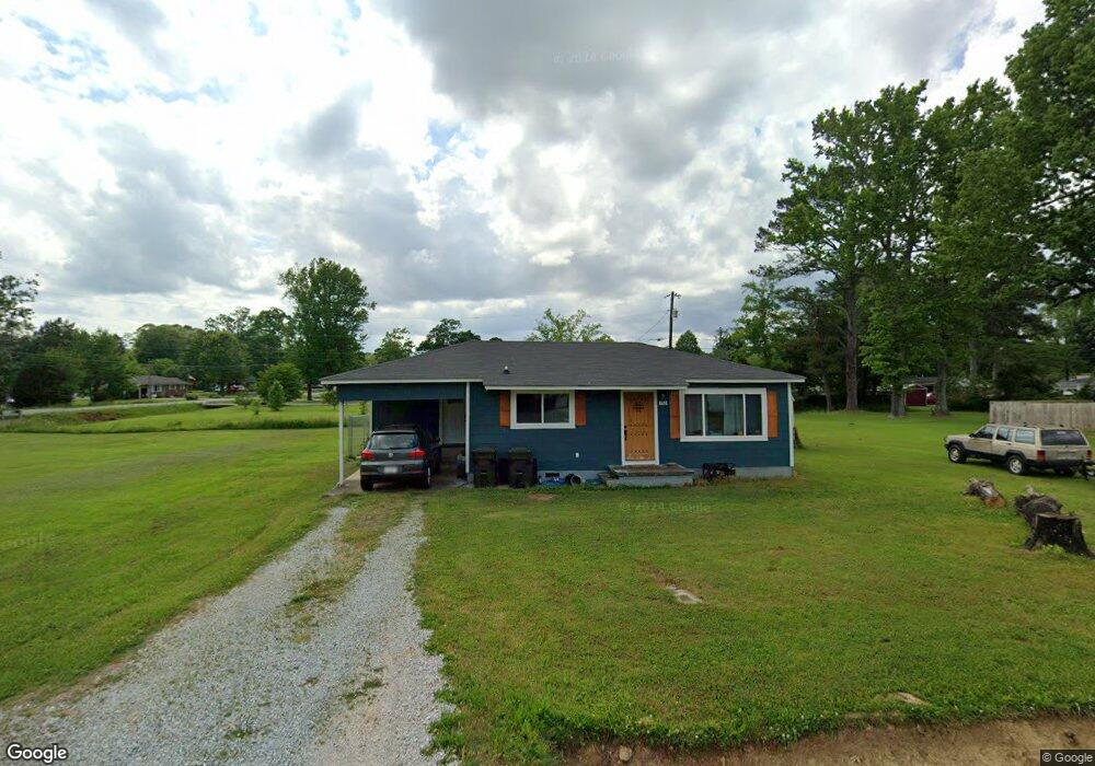
136 Coffman Cir Athens, AL 35611
Estimated Value: $87,000 - $181,000
Studio
--
Bath
768
Sq Ft
$180/Sq Ft
Est. Value
About This Home
This home is located at 136 Coffman Cir, Athens, AL 35611 and is currently estimated at $138,537, approximately $180 per square foot. 136 Coffman Cir is a home with nearby schools including Athens Elementary School, Athens Intermediate School, and Athens Middle School.
Ownership History
Date
Name
Owned For
Owner Type
Purchase Details
Closed on
May 13, 2022
Sold by
Valley Waterfront Llc
Bought by
Haggard Blake T
Current Estimated Value
Purchase Details
Closed on
Dec 3, 2020
Sold by
Valley Waterfront Llc
Bought by
Craig Emily N and Craig Paul C
Home Financials for this Owner
Home Financials are based on the most recent Mortgage that was taken out on this home.
Original Mortgage
$77,600
Interest Rate
2.8%
Mortgage Type
New Conventional
Purchase Details
Closed on
Sep 15, 2020
Sold by
Gordon William R and Gordon Thomas H
Bought by
Valley Waterfront Llc
Create a Home Valuation Report for This Property
The Home Valuation Report is an in-depth analysis detailing your home's value as well as a comparison with similar homes in the area
Home Values in the Area
Average Home Value in this Area
Purchase History
| Date | Buyer | Sale Price | Title Company |
|---|---|---|---|
| Haggard Blake T | $180,000 | Attorney Only | |
| Craig Emily N | $65,000 | None Available | |
| Valley Waterfront Llc | $85,000 | None Available |
Source: Public Records
Mortgage History
| Date | Status | Borrower | Loan Amount |
|---|---|---|---|
| Previous Owner | Craig Emily N | $77,600 |
Source: Public Records
Tax History
| Year | Tax Paid | Tax Assessment Tax Assessment Total Assessment is a certain percentage of the fair market value that is determined by local assessors to be the total taxable value of land and additions on the property. | Land | Improvement |
|---|---|---|---|---|
| 2025 | $638 | $15,940 | $0 | $0 |
| 2024 | $638 | $15,300 | $0 | $0 |
| 2023 | $612 | $15,300 | $0 | $0 |
| 2022 | $520 | $13,000 | $0 | $0 |
| 2021 | $457 | $11,420 | $0 | $0 |
| 2020 | $426 | $10,660 | $0 | $0 |
| 2019 | $392 | $9,800 | $0 | $0 |
| 2018 | $366 | $9,140 | $0 | $0 |
| 2017 | $366 | $9,140 | $0 | $0 |
| 2016 | $366 | $45,660 | $0 | $0 |
| 2015 | $366 | $9,140 | $0 | $0 |
| 2014 | $360 | $0 | $0 | $0 |
Source: Public Records
Map
Nearby Homes
- 902 Jackson Dr
- 706 Meadowview St
- 17864 Daniel Island Dr
- 17878 Daniel Island Dr
- 18 Sandra Ln
- 17892 Daniel Island Dr
- 17853 Daniel Island Dr
- 17861 Daniel Island Dr
- 17873 Daniel Island Dr
- 17885 Daniel Island Dr
- 106 Hammons St
- 1708 W Market St
- 806 2nd Ave
- 112 Sycamore Place
- 167 Sycamore Place
- 162 Sycamore Place
- Dupont Plan at Laurenwood
- Cabot Plan at Laurenwood
- Gardner Plan at Laurenwood
- Essex Plan at Laurenwood