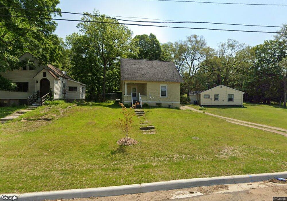
136 Hanover St Battle Creek, MI 49037
North Central NeighborhoodEstimated Value: $94,000 - $113,000
3
Beds
1
Bath
930
Sq Ft
$111/Sq Ft
Est. Value
About This Home
This home is located at 136 Hanover St, Battle Creek, MI 49037 and is currently estimated at $103,405, approximately $111 per square foot. 136 Hanover St is a home located in Calhoun County with nearby schools including Dudley School, Northwestern Middle School, and Battle Creek Central High School.
Ownership History
Date
Name
Owned For
Owner Type
Purchase Details
Closed on
Aug 5, 2004
Sold by
Oakland Enterprises Llc
Bought by
Keifer Robert and Keifer Julie
Current Estimated Value
Home Financials for this Owner
Home Financials are based on the most recent Mortgage that was taken out on this home.
Original Mortgage
$35,000
Outstanding Balance
$17,643
Interest Rate
6.25%
Mortgage Type
Unknown
Estimated Equity
$85,762
Purchase Details
Closed on
Jun 6, 2003
Sold by
Holder Estate Gertrude
Bought by
Bank One Na
Purchase Details
Closed on
Mar 25, 2003
Sold by
Holder Gertrude
Purchase Details
Closed on
Jan 17, 2000
Sold by
Holder Charles
Create a Home Valuation Report for This Property
The Home Valuation Report is an in-depth analysis detailing your home's value as well as a comparison with similar homes in the area
Home Values in the Area
Average Home Value in this Area
Purchase History
| Date | Buyer | Sale Price | Title Company |
|---|---|---|---|
| Keifer Robert | $45,000 | Fatic | |
| Bank One Na | $11,700 | -- | |
| -- | -- | -- | |
| -- | -- | -- |
Source: Public Records
Mortgage History
| Date | Status | Borrower | Loan Amount |
|---|---|---|---|
| Open | Keifer Robert | $35,000 | |
| Closed | Keifer Robert | $10,000 |
Source: Public Records
Tax History Compared to Growth
Tax History
| Year | Tax Paid | Tax Assessment Tax Assessment Total Assessment is a certain percentage of the fair market value that is determined by local assessors to be the total taxable value of land and additions on the property. | Land | Improvement |
|---|---|---|---|---|
| 2025 | -- | $24,000 | $0 | $0 |
| 2024 | $477 | $19,905 | $0 | $0 |
| 2023 | $545 | $16,920 | $0 | $0 |
| 2022 | $431 | $14,716 | $0 | $0 |
| 2021 | $514 | $11,011 | $0 | $0 |
| 2020 | $552 | $11,583 | $0 | $0 |
| 2019 | $554 | $11,744 | $0 | $0 |
| 2018 | $554 | $11,876 | $631 | $11,245 |
| 2017 | $552 | $12,702 | $0 | $0 |
| 2016 | $551 | $13,472 | $0 | $0 |
| 2015 | $540 | $15,136 | $2,948 | $12,188 |
| 2014 | $540 | $11,726 | $2,948 | $8,778 |
Source: Public Records
Map
Nearby Homes
- 46 Walter Ave
- 52 Roseneath Ave
- 216 Kendall St N
- 5 Beglin Ct
- 266 North Ave
- 435 Kendall St N
- 188 Roseneath Ave
- 224 Hubbard St
- 161 Wilds Ave
- 51 Latta St
- 16 Eagle St
- 273 Garfield Ave
- 253 Greenwood Ave
- 323 Garfield Ave
- 192 Fremont St
- 122 North Ave
- 45 Central St
- 35 Hubbard St
- V/L W Michigan 055 Ave
- 0 W Vanburen 032 St Unit 22040288
- 140 Hanover St
- 2 Helen M Montgomery Ave
- 144 Hanover St
- 137 Hazel St
- 154 Hanover St
- 157 Hazel St
- 160 Hanover St
- 163 Hazel St
- 158 Hazel St
- 54 Northside Dr E
- 58 Northside Dr E
- 164 Hazel St
- 52 Northside Dr E
- 169 Hazel St
- 51 Seedorff St
- 70 Northside Dr E
- 63 Seedorff St
- 51 Northside Dr E
- 77 Seedorff St
- 30 Northside Dr E