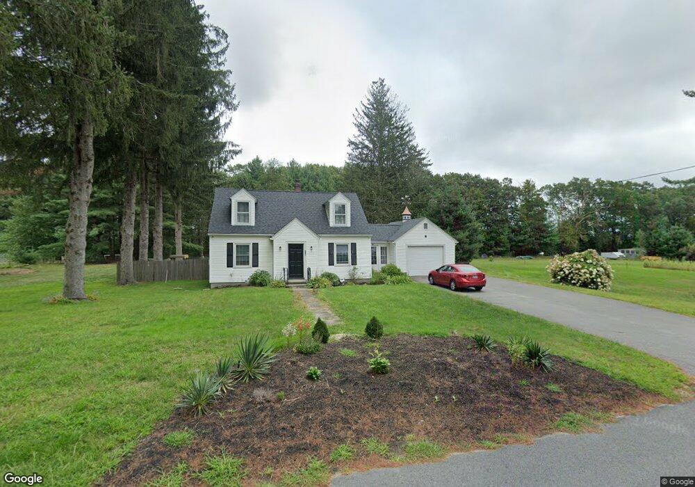
136 Richardson St Uxbridge, MA 01569
Estimated Value: $374,000 - $506,000
2
Beds
1
Bath
1,376
Sq Ft
$323/Sq Ft
Est. Value
About This Home
This home is located at 136 Richardson St, Uxbridge, MA 01569 and is currently estimated at $444,737, approximately $323 per square foot. 136 Richardson St is a home located in Worcester County with nearby schools including Uxbridge High School and Our Lady of the Valley Regional School.
Ownership History
Date
Name
Owned For
Owner Type
Purchase Details
Closed on
Feb 7, 2018
Sold by
Stefanick Mary A Est
Bought by
Dejardin Andrew T
Current Estimated Value
Home Financials for this Owner
Home Financials are based on the most recent Mortgage that was taken out on this home.
Original Mortgage
$144,000
Outstanding Balance
$121,955
Interest Rate
3.99%
Mortgage Type
New Conventional
Estimated Equity
$322,782
Purchase Details
Closed on
Jan 18, 2017
Sold by
Stefanick Steven M
Bought by
Stefanick Mary
Purchase Details
Closed on
Nov 22, 2016
Sold by
Stefanick Mary
Bought by
Stefanick Steven M
Create a Home Valuation Report for This Property
The Home Valuation Report is an in-depth analysis detailing your home's value as well as a comparison with similar homes in the area
Home Values in the Area
Average Home Value in this Area
Purchase History
| Date | Buyer | Sale Price | Title Company |
|---|---|---|---|
| Dejardin Andrew T | $184,900 | -- | |
| Stefanick Mary | -- | -- | |
| Stefanick Steven M | -- | -- |
Source: Public Records
Mortgage History
| Date | Status | Borrower | Loan Amount |
|---|---|---|---|
| Open | Dejardin Andrew T | $144,000 |
Source: Public Records
Tax History
| Year | Tax Paid | Tax Assessment Tax Assessment Total Assessment is a certain percentage of the fair market value that is determined by local assessors to be the total taxable value of land and additions on the property. | Land | Improvement |
|---|---|---|---|---|
| 2025 | $48 | $364,800 | $160,600 | $204,200 |
| 2024 | $4,485 | $347,100 | $152,800 | $194,300 |
| 2023 | $4,238 | $303,800 | $131,700 | $172,100 |
| 2022 | $4,064 | $268,100 | $116,000 | $152,100 |
| 2021 | $4,107 | $259,600 | $113,600 | $146,000 |
| 2020 | $4,679 | $279,500 | $145,100 | $134,400 |
| 2019 | $4,711 | $271,500 | $145,100 | $126,400 |
| 2018 | $4,413 | $257,000 | $145,100 | $111,900 |
| 2017 | $3,931 | $231,800 | $136,700 | $95,100 |
| 2016 | $3,681 | $209,500 | $120,600 | $88,900 |
| 2015 | $3,611 | $207,500 | $120,600 | $86,900 |
Source: Public Records
Map
Nearby Homes
- 197 Crownshield Ave Unit 16B
- 197 Crownshield Ave Unit 16A
- 197 Crownshield Ave Unit 16C
- 314 Richardson St
- 79 High St
- 5 Peter St Unit D
- 395 High St
- 61 Spring Hill Dr Unit 61
- 16 Farnum St
- 86 Hunter Rd
- 56 S Main St
- 376 Douglas St
- 11 Summerfield Dr Unit 11
- 70 Chocolog Rd
- 145 Mantell Rd
- 169 Mantell Rd
- 137 Mantell Rd
- 45 Turner Farm Rd
- 46 Turner Farm Rd
- 47 Turner Farm Rd
- 137 Richardson St
- 2 Landry Ln
- 143 Richardson St
- 163 Crownshield Ave Unit 11C
- 153 Richardson St
- Lot 4R Richardson St
- Lot 2R Richardson St
- Lot 3 Richardson St Unit Lot 3
- 117 Richardson St
- 179 Crownshield Ave Unit 13-D
- 31 Cotton Mill Way Unit E
- 31 Cotton Mill Way
- 27 Cotton Mill Way
- 27 Cotton Mill Way Unit 177
- 39 Cotton Mill Way
- 37 Cotton Mill Way
- 29 Cotton Mill Way
- 33 Cotton Mill Way
- 33 Cotton Mill Way Unit 176
- 37 Cotton Mill Way Unit 180
Your Personal Tour Guide
Ask me questions while you tour the home.