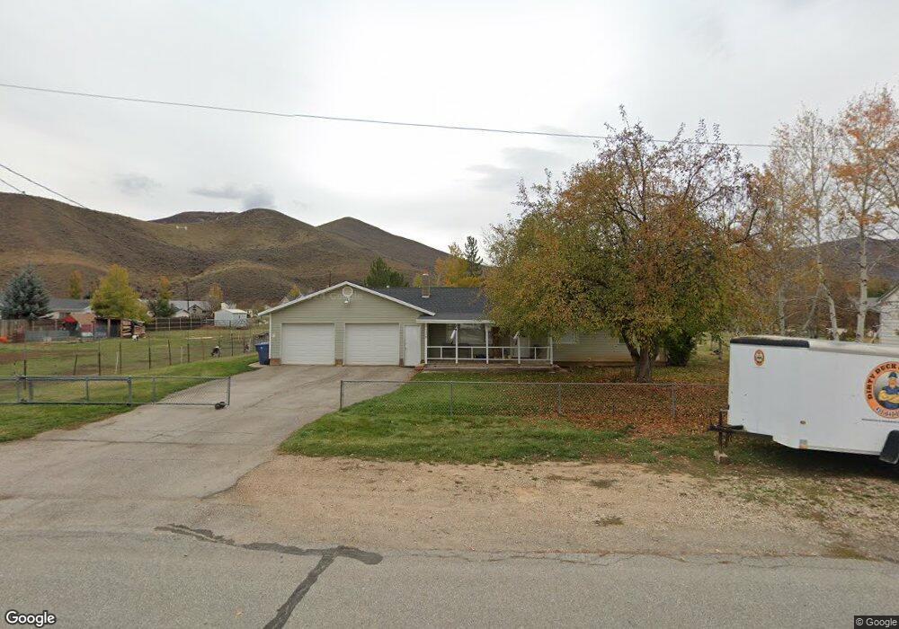
136 S 200 W Henefer, UT 84033
Estimated Value: $498,000 - $585,337
3
Beds
2
Baths
1,840
Sq Ft
$297/Sq Ft
Est. Value
About This Home
This home is located at 136 S 200 W, Henefer, UT 84033 and is currently estimated at $545,584, approximately $296 per square foot. 136 S 200 W is a home located in Summit County with nearby schools including North Summit Middle School, North Summit Elementary School, and North Summit High School.
Ownership History
Date
Name
Owned For
Owner Type
Purchase Details
Closed on
Dec 30, 2020
Sold by
Fawcett Lynne and Rees Connie F
Bought by
Blonquist Ashlin and Murdock Hayden Wade
Current Estimated Value
Home Financials for this Owner
Home Financials are based on the most recent Mortgage that was taken out on this home.
Original Mortgage
$329,797
Outstanding Balance
$292,262
Interest Rate
2.7%
Mortgage Type
New Conventional
Estimated Equity
$253,322
Purchase Details
Closed on
Nov 30, 2020
Sold by
Fawcett Yvonne C
Bought by
Richard G And Yvonne C Fawcett Family Tr and Fawcett
Home Financials for this Owner
Home Financials are based on the most recent Mortgage that was taken out on this home.
Original Mortgage
$329,797
Outstanding Balance
$292,262
Interest Rate
2.7%
Mortgage Type
New Conventional
Estimated Equity
$253,322
Create a Home Valuation Report for This Property
The Home Valuation Report is an in-depth analysis detailing your home's value as well as a comparison with similar homes in the area
Purchase History
| Date | Buyer | Sale Price | Title Company |
|---|---|---|---|
| Blonquist Ashlin | -- | Us Title Insurance Agency | |
| Richard G And Yvonne C Fawcett Family Tr | -- | -- |
Source: Public Records
Mortgage History
| Date | Status | Borrower | Loan Amount |
|---|---|---|---|
| Open | Blonquist Ashlin | $329,797 |
Source: Public Records
Tax History
| Year | Tax Paid | Tax Assessment Tax Assessment Total Assessment is a certain percentage of the fair market value that is determined by local assessors to be the total taxable value of land and additions on the property. | Land | Improvement |
|---|---|---|---|---|
| 2025 | $1,671 | $302,167 | $96,250 | $205,917 |
| 2024 | $1,502 | $262,546 | $77,000 | $185,546 |
| 2023 | $1,502 | $263,416 | $68,750 | $194,666 |
| 2022 | $1,297 | $231,338 | $68,750 | $162,588 |
| 2021 | $1,028 | $148,237 | $41,250 | $106,987 |
| 2020 | $1,077 | $148,237 | $41,250 | $106,987 |
| 2019 | $1,053 | $126,529 | $27,500 | $99,029 |
| 2018 | $11 | $126,529 | $27,500 | $99,029 |
| 2017 | $0 | $101,369 | $24,750 | $76,619 |
| 2016 | $882 | $101,369 | $24,750 | $76,619 |
| 2015 | $918 | $101,369 | $0 | $0 |
| 2013 | $953 | $101,369 | $0 | $0 |
Source: Public Records
Map
Nearby Homes
- 335 Memorial Park Rd
- 130 E Center St
- 209 E Main St
- 2687 E Henefer Rd Unit 1
- 11360 Skyline Dr Unit 170
- 141 Sky Line Rd Unit 141
- 10976 Skyline Rd Unit 202
- 1069 Sego Ct Unit 21
- 267 Mackenzie Ln Unit 17
- 283 Mackenzie Ln Unit 15
- 574 Village View Dr Unit 7
- 296 Mackenzie Ln Unit 20
- 16 W 200 N
- 0 N Industrial Park Rd Unit 12504107
- Tbd
- 6100 Utah 66
- 66 50 N
- 246 E 100 N
- 749 Village View Dr Unit 65
- 82 S Main St
Your Personal Tour Guide
Ask me questions while you tour the home.