
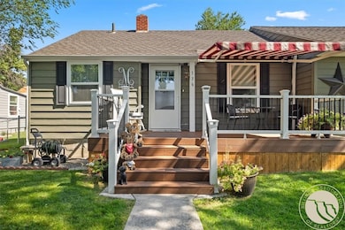
136 W 1st Ave N Columbus, MT 59019
Estimated payment $1,940/month
Highlights
- Deck
- Cooling Available
- Forced Air Heating System
- Front Porch
- Shed
- Fenced
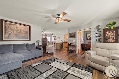
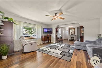
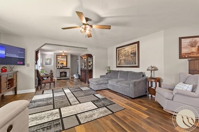
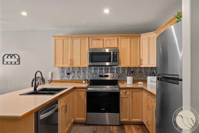
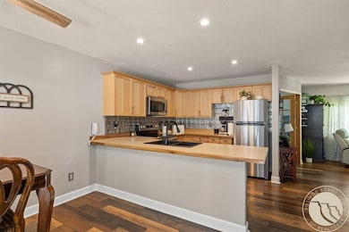
About This Home
This beautifully updated home in a prime central Columbus location offers all main-floor living with 3 bedrooms, 2 full baths, an office/den, a separate dining area, and a breakfast bar. A recently built deck overlooks the fenced backyard with alley access. Interior highlights include hardwood floors, a spacious primary suite with a walk-in closet, and a remodeled bath and laundry area. Recent updates include appliances, windows, wiring, plumbing, paint, flooring, and lighting. Convenient midtown location close to shopping, dining, and everyday amenities. Call today!
Listing Agent
Western Skies Real Estate Brokerage Phone: (406) 860-7943 License #RRE-RBS-LIC-70471 Listed on: 08/06/2025
Home Details
Home Type
- Single Family
Est. Annual Taxes
- $1,779
Year Built
- Built in 1942
Lot Details
- 7,700 Sq Ft Lot
- Fenced
Parking
- Alley Access
Home Design
- Shingle Roof
- Asphalt Roof
- Metal Siding
Interior Spaces
- 1,543 Sq Ft Home
- 1-Story Property
Kitchen
- Oven
- Electric Range
- Microwave
- Dishwasher
Bedrooms and Bathrooms
- 3 Main Level Bedrooms
- 2 Full Bathrooms
Outdoor Features
- Deck
- Shed
- Front Porch
Schools
- Columbus Elementary And Middle School
- Columbus High School
Utilities
- Cooling Available
- Forced Air Heating System
Community Details
- Myers And Nice Add Subdivision
Listing and Financial Details
- Assessor Parcel Number 30415
Map
Home Values in the Area
Average Home Value in this Area
Tax History
| Year | Tax Paid | Tax Assessment Tax Assessment Total Assessment is a certain percentage of the fair market value that is determined by local assessors to be the total taxable value of land and additions on the property. | Land | Improvement |
|---|---|---|---|---|
| 2025 | $1,598 | $307,400 | $0 | $0 |
| 2024 | $1,779 | $225,200 | $0 | $0 |
| 2023 | $1,727 | $225,200 | $0 | $0 |
| 2022 | $1,130 | $137,300 | $0 | $0 |
| 2021 | $1,134 | $137,300 | $0 | $0 |
| 2020 | $1,088 | $128,200 | $0 | $0 |
| 2019 | $1,149 | $128,200 | $0 | $0 |
| 2018 | $1,012 | $121,400 | $0 | $0 |
| 2017 | $1,055 | $121,400 | $0 | $0 |
| 2016 | $833 | $98,100 | $0 | $0 |
| 2015 | $801 | $98,100 | $0 | $0 |
| 2014 | $1,058 | $71,117 | $0 | $0 |
Property History
| Date | Event | Price | List to Sale | Price per Sq Ft |
|---|---|---|---|---|
| 09/17/2025 09/17/25 | Price Changed | $340,000 | -2.9% | $220 / Sq Ft |
| 09/10/2025 09/10/25 | Price Changed | $350,000 | -1.4% | $227 / Sq Ft |
| 08/06/2025 08/06/25 | For Sale | $355,000 | -- | $230 / Sq Ft |
Purchase History
| Date | Type | Sale Price | Title Company |
|---|---|---|---|
| Warranty Deed | -- | -- | |
| Warranty Deed | -- | -- | |
| Warranty Deed | -- | -- |
Mortgage History
| Date | Status | Loan Amount | Loan Type |
|---|---|---|---|
| Open | $128,000 | No Value Available | |
| Previous Owner | $123,800 | No Value Available | |
| Previous Owner | $90,800 | No Value Available |
Source: Billings Multiple Listing Service
MLS Number: 354763
APN: 32-0814-21-4-07-03-0000
Disclaimer: Certain information contained herein is derived from information provided by parties other than Homes.com. All information provided is deemed reliable, but is not guaranteed to be accurate and should be independently verified.
![]() IDX information is provided exclusively for personal, non-commercial use, and may not be used for any purpose other than to identify prospective properties consumers may be interested in purchasing. Information is deemed reliable but not guaranteed.
IDX information is provided exclusively for personal, non-commercial use, and may not be used for any purpose other than to identify prospective properties consumers may be interested in purchasing. Information is deemed reliable but not guaranteed.
- 37 W 3rd Ave N
- 115 W 6th Ave N
- 219 4th St
- TBD Centennial Rd
- 427 N 4th St
- 55 Centennial Rd
- 526 E 2nd Ave N
- 4552 Montana 78
- 692 Quarry Rd
- 1026 Woodbine Creek Dr
- 403 11th St N
- 1130 E 2nd Ave N
- 94 Upper Flat Rd
- 96 Wagon Trail Rd
- 66 Dolan Ln
- 49 Gateway Dr
- 5 Michigan Ridge Rd
- 5 Shane Ridge Rd
- 11 E Upper Flat Rd
- 4 Deer Dr
