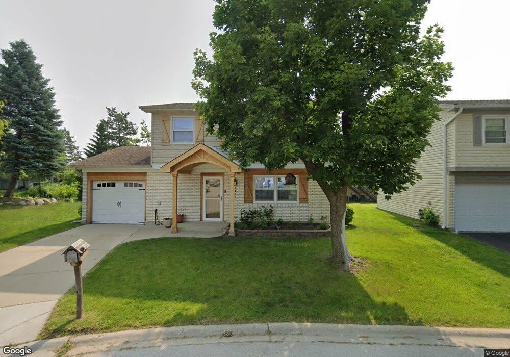
1360 Nantucket Ct Hoffman Estates, IL 60192
South Ridge NeighborhoodEstimated Value: $374,000 - $404,000
3
Beds
3
Baths
1,606
Sq Ft
$244/Sq Ft
Est. Value
About This Home
This home is located at 1360 Nantucket Ct, Hoffman Estates, IL 60192 and is currently estimated at $391,366, approximately $243 per square foot. 1360 Nantucket Ct is a home located in Cook County with nearby schools including Thomas Jefferson Elementary School, Frank C. Whiteley Elementary School, and William Fremd High School.
Ownership History
Date
Name
Owned For
Owner Type
Purchase Details
Closed on
May 30, 2003
Sold by
Bedus Wojciech
Bought by
Bedus Wojciech and Bedus Boguslawa
Current Estimated Value
Home Financials for this Owner
Home Financials are based on the most recent Mortgage that was taken out on this home.
Original Mortgage
$150,000
Interest Rate
5.37%
Mortgage Type
Unknown
Create a Home Valuation Report for This Property
The Home Valuation Report is an in-depth analysis detailing your home's value as well as a comparison with similar homes in the area
Home Values in the Area
Average Home Value in this Area
Purchase History
| Date | Buyer | Sale Price | Title Company |
|---|---|---|---|
| Bedus Wojciech | -- | -- | |
| Bedus Wojciech | $219,000 | Pntn |
Source: Public Records
Mortgage History
| Date | Status | Borrower | Loan Amount |
|---|---|---|---|
| Previous Owner | Bedus Wojciech | $150,000 |
Source: Public Records
Tax History
| Year | Tax Paid | Tax Assessment Tax Assessment Total Assessment is a certain percentage of the fair market value that is determined by local assessors to be the total taxable value of land and additions on the property. | Land | Improvement |
|---|---|---|---|---|
| 2025 | $7,568 | $37,000 | $4,872 | $32,128 |
| 2024 | $7,568 | $24,958 | $4,176 | $20,782 |
| 2023 | $7,283 | $28,000 | $4,176 | $23,824 |
| 2022 | $7,283 | $28,000 | $4,176 | $23,824 |
| 2021 | $7,079 | $24,469 | $2,900 | $21,569 |
| 2020 | $7,488 | $25,965 | $2,900 | $23,065 |
| 2019 | $7,411 | $28,787 | $2,900 | $25,887 |
| 2018 | $6,887 | $25,174 | $2,668 | $22,506 |
| 2017 | $6,777 | $25,174 | $2,668 | $22,506 |
| 2016 | $6,717 | $25,773 | $2,668 | $23,105 |
| 2015 | $6,016 | $21,981 | $2,436 | $19,545 |
| 2014 | $6,174 | $22,817 | $2,436 | $20,381 |
| 2013 | $6,000 | $22,817 | $2,436 | $20,381 |
Source: Public Records
Map
Nearby Homes
- 4475 Olmstead Dr
- 4480 Thornbark Dr
- 4175 Victoria Dr
- 1404 W Sapphire Dr
- 4485 Bayside Cir
- 4620 Olmstead Dr
- 1690 Cape Breton Ct
- 940 Freeman Rd
- 1280 Clover Ln
- 1281 Old Timber Ct
- 3881 Bordeaux Dr
- 4791 Amber Cir
- 4075 N Parkside Dr
- 825 Concord Ln
- 765 Concord Ln
- 4 Ashford Ct
- 61 E Rd
- 61 E Rd
- 61 E Palatine #4 Rd
- 10 Carnoustie Ln
- 1355 Nantucket Ct
- 1370 Nantucket Ct
- 1380 Fortune Bay Ct
- 1375 Fortune Bay Ct
- 1365 Nantucket Ct
- 1380 Nantucket Ct
- 1375 Gloucester Ct
- 1370 Fortune Bay Ct
- 1375 Nantucket Ct
- 1365 Gloucester Ct
- 1365 Fortune Bay Ct
- 1385 Gloucester Ct
- 1385 Nantucket Ct
- 1390 Nantucket Ct
- 1360 Fortune Bay Ct
- 1345 Rock Cove Ct
- 1400 Lake Edge Ct
- 1355 Fortune Bay Ct
- 1395 Gloucester Ct
- 1395 Nantucket Ct
Your Personal Tour Guide
Ask me questions while you tour the home.