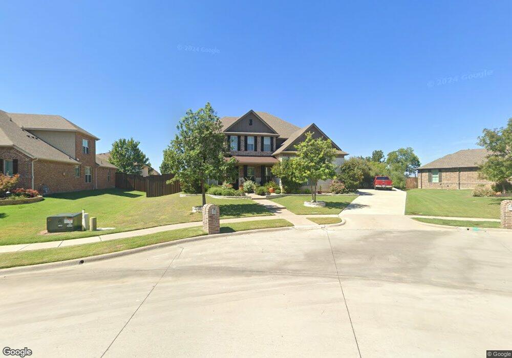
1361 Kima Ln Prosper, TX 75078
Estimated Value: $827,000 - $924,000
4
Beds
4
Baths
3,579
Sq Ft
$241/Sq Ft
Est. Value
About This Home
This home is located at 1361 Kima Ln, Prosper, TX 75078 and is currently estimated at $864,258, approximately $241 per square foot. 1361 Kima Ln is a home located in Collin County with nearby schools including Ralph and Mary Lynn Boyer Elementary School, Reynolds Middle School, and Prosper High School.
Ownership History
Date
Name
Owned For
Owner Type
Purchase Details
Closed on
Dec 30, 2015
Sold by
Beazer Homes Texas Lp
Bought by
Kline Matthew J
Current Estimated Value
Home Financials for this Owner
Home Financials are based on the most recent Mortgage that was taken out on this home.
Original Mortgage
$358,400
Outstanding Balance
$285,230
Interest Rate
3.98%
Mortgage Type
New Conventional
Estimated Equity
$579,028
Create a Home Valuation Report for This Property
The Home Valuation Report is an in-depth analysis detailing your home's value as well as a comparison with similar homes in the area
Home Values in the Area
Average Home Value in this Area
Purchase History
| Date | Buyer | Sale Price | Title Company |
|---|---|---|---|
| Kline Matthew J | -- | Fatco |
Source: Public Records
Mortgage History
| Date | Status | Borrower | Loan Amount |
|---|---|---|---|
| Open | Kline Matthew J | $358,400 |
Source: Public Records
Tax History Compared to Growth
Tax History
| Year | Tax Paid | Tax Assessment Tax Assessment Total Assessment is a certain percentage of the fair market value that is determined by local assessors to be the total taxable value of land and additions on the property. | Land | Improvement |
|---|---|---|---|---|
| 2025 | $11,592 | $758,287 | $207,000 | $577,124 |
| 2024 | $11,592 | $689,352 | $207,000 | $574,430 |
| 2023 | $11,592 | $818,586 | $207,000 | $611,586 |
| 2022 | $14,732 | $673,746 | $172,500 | $501,246 |
| 2021 | $11,496 | $517,921 | $115,000 | $402,921 |
| 2020 | $10,863 | $463,327 | $115,000 | $348,327 |
| 2019 | $11,925 | $486,352 | $109,250 | $377,102 |
| 2018 | $11,855 | $481,494 | $103,500 | $377,994 |
| 2017 | $11,727 | $476,314 | $103,500 | $372,814 |
| 2016 | $8,678 | $349,979 | $103,500 | $246,479 |
| 2015 | $1,630 | $72,680 | $72,680 | $0 |
Source: Public Records
Map
Nearby Homes
- 1300 Brittany Way
- 621 Sunbury Ln
- 320 Saint Mark Ln
- 221 Saint Mark Ln
- 1501 Latigo Ct
- 201 Saint Mark Ln
- 150 Darian Dr
- 841 Brittany Way
- 971 Georgetown Place
- 991 Georgetown Place
- 140 Godstone Ln
- 851 Sibyl Ln
- 651 Table Rock Dr
- 1700 Pepperdine Place
- 981 Georgetown Place
- 630 Table Rock Dr
- 1661 Pepperdine Place
- 981 Stanford Ln
- 1240 Concho Trail
- 1100 Circle j Trail
- 1360 Brittany Way
- 1341 Kima Ln
- 1340 Brittany Way
- 1380 Brittany Way
- 561 Lockton Ln
- 1321 Kima Ln
- 560 Lockton Ln
- 1320 Brittany Way
- 600 Lockton Ln
- 601 Lockton Ln
- 1381 Brittany Way
- 600 Lockton Ln
- 1301 Kima Ln
- 521 Elizabeth Ln
- 1341 Brittany Way
- 541 Elizabeth Ln
- 1361 Brittany Way
- 561 Debbie Ct
- 561 Elizabeth Ln
- 1321 Brittany Way