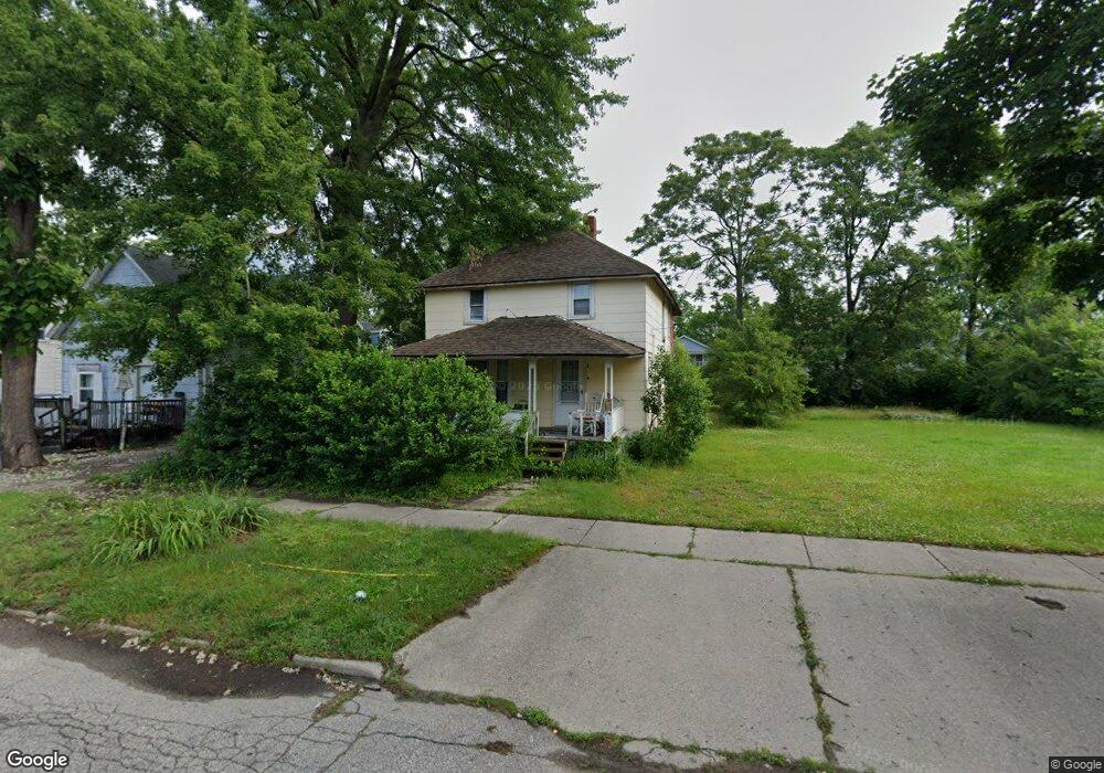
1361 Poplar St Flint, MI 48503
Eastside NeighborhoodEstimated Value: $15,000 - $77,000
3
Beds
1
Bath
1,144
Sq Ft
$45/Sq Ft
Est. Value
About This Home
This home is located at 1361 Poplar St, Flint, MI 48503 and is currently estimated at $51,659, approximately $45 per square foot. 1361 Poplar St is a home located in Genesee County with nearby schools including Doyle/Ryder School, Flint Cultural Center Academy, and WAY Academy of Flint.
Ownership History
Date
Name
Owned For
Owner Type
Purchase Details
Closed on
Jan 8, 2008
Sold by
Rock Hall Investments Inc
Bought by
Lafave Joyce
Current Estimated Value
Purchase Details
Closed on
Dec 19, 2007
Sold by
Destiny Ventures Llc
Bought by
Rockhall Investments Inc
Purchase Details
Closed on
Nov 19, 2007
Sold by
The Bank Of New York
Bought by
Destiny Ventures Llc
Purchase Details
Closed on
Jul 19, 2006
Sold by
Hastings Jodi
Bought by
The Bank Of New York and Eqcc Asset Backed Certificates Series 20
Purchase Details
Closed on
Aug 21, 2000
Sold by
Ramirez Ramirez H and Ramirez Tressa A
Bought by
Hastings Jodi
Create a Home Valuation Report for This Property
The Home Valuation Report is an in-depth analysis detailing your home's value as well as a comparison with similar homes in the area
Home Values in the Area
Average Home Value in this Area
Purchase History
| Date | Buyer | Sale Price | Title Company |
|---|---|---|---|
| Lafave Joyce | $9,500 | Metropol | |
| Rockhall Investments Inc | $2,000 | Metropol | |
| Destiny Ventures Llc | -- | E Title Agency Inc | |
| The Bank Of New York | $50,198 | None Available | |
| Hastings Jodi | $50,000 | Guaranty Title Company |
Source: Public Records
Tax History Compared to Growth
Tax History
| Year | Tax Paid | Tax Assessment Tax Assessment Total Assessment is a certain percentage of the fair market value that is determined by local assessors to be the total taxable value of land and additions on the property. | Land | Improvement |
|---|---|---|---|---|
| 2025 | $745 | $12,300 | $0 | $0 |
| 2024 | $699 | $9,300 | $0 | $0 |
| 2023 | $690 | $9,200 | $0 | $0 |
| 2022 | $0 | $8,900 | $0 | $0 |
| 2021 | $695 | $8,100 | $0 | $0 |
| 2020 | $649 | $7,300 | $0 | $0 |
| 2019 | $641 | $6,200 | $0 | $0 |
| 2018 | $686 | $5,900 | $0 | $0 |
| 2017 | $598 | $0 | $0 | $0 |
| 2016 | $594 | $0 | $0 | $0 |
| 2015 | -- | $0 | $0 | $0 |
| 2014 | -- | $0 | $0 | $0 |
| 2012 | -- | $7,400 | $0 | $0 |
Source: Public Records
Map
Nearby Homes
- 1379 Washington Ave
- 1652 Wisconsin Ave
- 1318 Cronk Ave
- 1273 Broadway Blvd
- 1529 Broadway Blvd
- 1215 Bennett Ave
- 915 E Court #206 St Unit 206
- 915 E Court St Unit 104
- 915 E Court St
- 1501 Arlington Ave
- 903 E Court St
- 621 Pierson St
- 620 E 2nd St
- 607 East St
- 1622 Arlington Ave
- 1513 Jane Ave
- 1706 Wilberforce Cir
- 1510 N Vernon Ave
- 1710 Wilberforce Cir
- 2301 Missouri Ave
- 1365 Poplar St
- 1357 Poplar St
- 1369 Poplar St
- 1353 Poplar St
- 1360 Roosevelt Ave
- 1364 Roosevelt Ave
- 1371 Poplar St
- 1356 Roosevelt Ave
- 1368 Roosevelt Ave
- 1375 Poplar St
- 1352 Roosevelt Ave
- 1376 Roosevelt Ave
- 1327 Poplar St
- 1377 Poplar St
- 1379 Poplar St
- 920 Walnut St
- 1326 Roosevelt Ave
- 1323 Poplar St
- 1328 Poplar St
- 1380 Roosevelt Ave