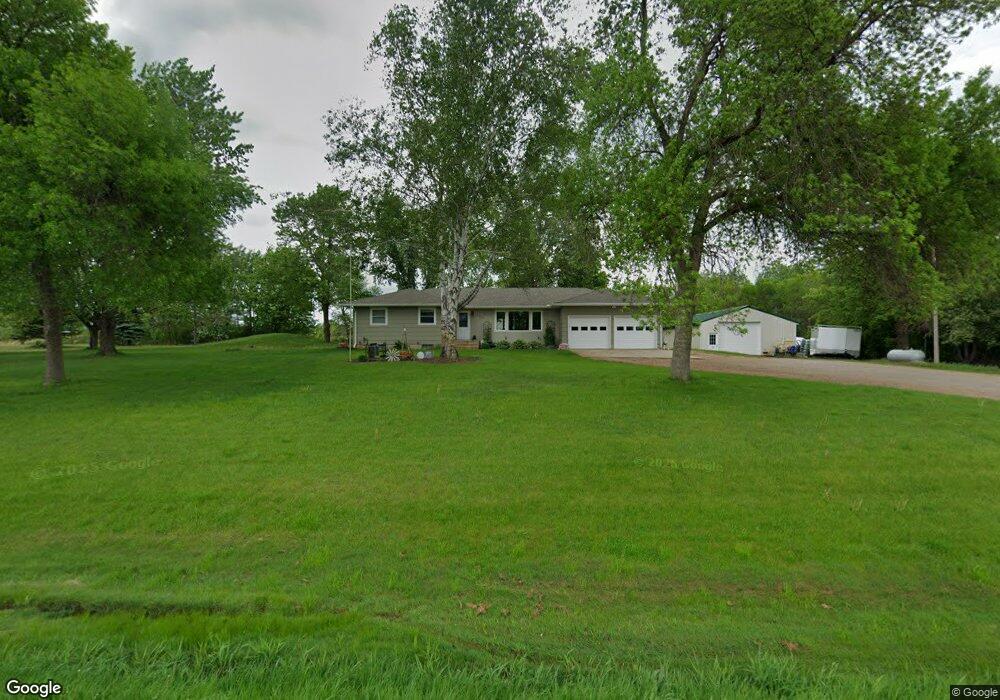
13610 Highway 25 SW Watertown, MN 55388
Estimated Value: $408,000 - $466,000
4
Beds
3
Baths
1,800
Sq Ft
$248/Sq Ft
Est. Value
About This Home
This home is located at 13610 Highway 25 SW, Watertown, MN 55388 and is currently estimated at $446,416, approximately $248 per square foot. 13610 Highway 25 SW is a home located in Carver County with nearby schools including Watertown-Mayer Elementary School, Watertown-Mayer Middle School, and Watertown Mayer High School.
Ownership History
Date
Name
Owned For
Owner Type
Purchase Details
Closed on
Sep 13, 2018
Sold by
Sydloski Kevin P and Sydloski Michelle
Bought by
Erickson Jason and Johnson Jennifer
Current Estimated Value
Home Financials for this Owner
Home Financials are based on the most recent Mortgage that was taken out on this home.
Original Mortgage
$297,618
Outstanding Balance
$263,054
Interest Rate
5.25%
Mortgage Type
FHA
Estimated Equity
$183,362
Purchase Details
Closed on
Sep 29, 2015
Sold by
Swartzer Walter J and Swartzer Irene E
Bought by
Sydloski Kevin P and Sydloski Michelle
Home Financials for this Owner
Home Financials are based on the most recent Mortgage that was taken out on this home.
Original Mortgage
$196,000
Interest Rate
3.84%
Mortgage Type
New Conventional
Create a Home Valuation Report for This Property
The Home Valuation Report is an in-depth analysis detailing your home's value as well as a comparison with similar homes in the area
Home Values in the Area
Average Home Value in this Area
Purchase History
| Date | Buyer | Sale Price | Title Company |
|---|---|---|---|
| Erickson Jason | $325,000 | Watermark Title Agency | |
| Sydloski Kevin P | $245,000 | North American Title Company |
Source: Public Records
Mortgage History
| Date | Status | Borrower | Loan Amount |
|---|---|---|---|
| Open | Erickson Jason | $297,618 | |
| Previous Owner | Sydloski Kevin P | $196,000 |
Source: Public Records
Tax History Compared to Growth
Tax History
| Year | Tax Paid | Tax Assessment Tax Assessment Total Assessment is a certain percentage of the fair market value that is determined by local assessors to be the total taxable value of land and additions on the property. | Land | Improvement |
|---|---|---|---|---|
| 2025 | $3,466 | $401,400 | $155,000 | $246,400 |
| 2024 | $3,580 | $394,200 | $150,000 | $244,200 |
| 2023 | $3,424 | $403,000 | $150,000 | $253,000 |
| 2022 | $3,196 | $381,000 | $145,500 | $235,500 |
| 2021 | $3,258 | $299,900 | $111,400 | $188,500 |
| 2020 | $3,272 | $299,900 | $111,400 | $188,500 |
| 2019 | $2,946 | $270,900 | $101,700 | $169,200 |
| 2018 | $2,940 | $270,900 | $101,700 | $169,200 |
| 2017 | $2,730 | $254,400 | $95,100 | $159,300 |
| 2016 | $2,328 | $178,400 | $0 | $0 |
| 2015 | $2,068 | $168,100 | $0 | $0 |
| 2014 | $2,068 | $147,500 | $0 | $0 |
Source: Public Records
Map
Nearby Homes
- 604 White St SW Unit 35
- 604 White St SW
- 605 Stevens St SW Unit 43
- xxx Stevens St SW
- 600 Jefferson Ave SW
- 829 Reo Rd
- 313 Angel Ave SW
- 417 Lewis Ave N
- 115 Riverside Terrace Dr Unit 115
- 29 Riverside Terrace Dr Unit 29
- 316 Grove Ave SE
- 575 Industrial Blvd
- 555 Industrial Blvd
- 516 Industrial Blvd
- 120 Riverside Terrace Dr Unit 102
- 536 Industrial Blvd
- 85 Riverside Terrace Dr Unit 85
- 160 Wildwood Cir Unit 160
- 1290 Knight Ln
- XXX Newton Ave SE
- 13625 Highway 25 SW
- 13520 Highway 25 SW
- 1835 Ridge Ave
- 1820 Ridge Ave
- 13615 Highway 25 SW
- XXXX Minnesota 25
- 1975 Ridge Ave
- 13355 Highway 25 SW
- 1920 Ridge Ave
- XXX Ridge Ave
- 2015 Ridge Ave
- 13950 County Road 20
- 13955 County Road 20
- 13275 Highway 25 SW
- 13265 Highway 25 SW
- 13985 County Road 20
- 1720 Quarry Ave
- 2155 Ridge Ave
- 10950 10950 County Road 20--
- 13225 Highway 25 SW