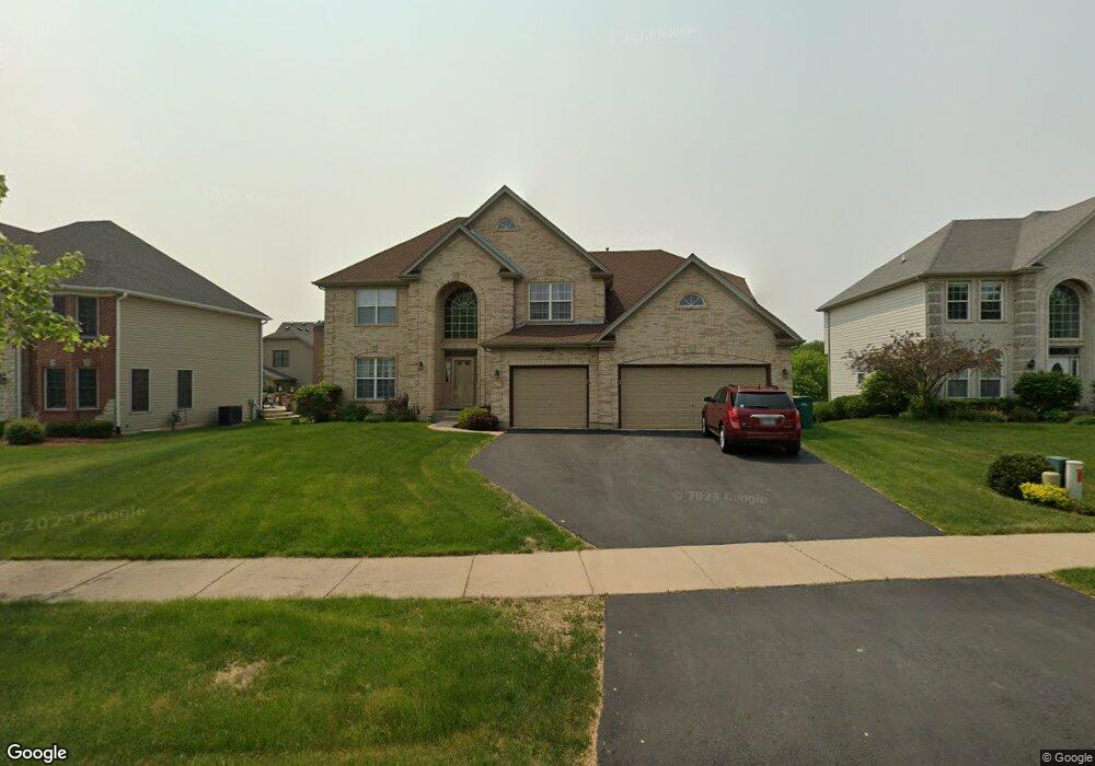
13614 Rockefeller Cir Plainfield, IL 60544
North Plainfield NeighborhoodEstimated Value: $544,100 - $581,000
Studio
2
Baths
2,951
Sq Ft
$193/Sq Ft
Est. Value
About This Home
This home is located at 13614 Rockefeller Cir, Plainfield, IL 60544 and is currently estimated at $568,775, approximately $192 per square foot. 13614 Rockefeller Cir is a home located in Will County with nearby schools including Eagle Pointe Elementary School, Heritage Grove Middle School, and Plainfield North High School.
Ownership History
Date
Name
Owned For
Owner Type
Purchase Details
Closed on
Nov 20, 2006
Sold by
Park National Bank
Bought by
Guice Henry B and Guice Patricia
Current Estimated Value
Home Financials for this Owner
Home Financials are based on the most recent Mortgage that was taken out on this home.
Original Mortgage
$327,004
Outstanding Balance
$191,129
Interest Rate
6%
Mortgage Type
Purchase Money Mortgage
Estimated Equity
$377,646
Create a Home Valuation Report for This Property
The Home Valuation Report is an in-depth analysis detailing your home's value as well as a comparison with similar homes in the area
Home Values in the Area
Average Home Value in this Area
Purchase History
| Date | Buyer | Sale Price | Title Company |
|---|---|---|---|
| Guice Henry B | $410,000 | Ticor Title |
Source: Public Records
Mortgage History
| Date | Status | Borrower | Loan Amount |
|---|---|---|---|
| Open | Guice Henry B | $327,004 |
Source: Public Records
Tax History
| Year | Tax Paid | Tax Assessment Tax Assessment Total Assessment is a certain percentage of the fair market value that is determined by local assessors to be the total taxable value of land and additions on the property. | Land | Improvement |
|---|---|---|---|---|
| 2024 | $11,694 | $166,620 | $34,390 | $132,230 |
| 2023 | $11,694 | $150,487 | $31,060 | $119,427 |
| 2022 | $10,484 | $135,158 | $27,896 | $107,262 |
| 2021 | $9,905 | $126,316 | $26,071 | $100,245 |
| 2020 | $9,802 | $122,732 | $25,331 | $97,401 |
| 2019 | $9,423 | $116,943 | $24,136 | $92,807 |
| 2018 | $9,004 | $109,874 | $22,677 | $87,197 |
| 2017 | $8,727 | $104,413 | $21,550 | $82,863 |
| 2016 | $8,170 | $95,820 | $20,553 | $75,267 |
| 2015 | $7,533 | $89,761 | $19,253 | $70,508 |
| 2014 | $7,533 | $84,611 | $18,573 | $66,038 |
| 2013 | $7,533 | $84,611 | $18,573 | $66,038 |
Source: Public Records
Map
Nearby Homes
- 13526 S Golden Eagle Cir
- 13802 S Quail Run Dr
- 24331 Norwood Dr
- 13066 S Sydney Cir
- 25004 Chelsea Ln
- 2912 Savana Dr
- 2907 Savana Dr
- 2921 Savana Dr
- 2915 Savana Dr
- 2908 Savana Dr
- 2916 Savana Dr
- 2917 Savana Dr
- 12966 S Twin Pines Ln
- 12901 S Twin Pines Ln
- 12950 S Twin Pines Ln
- 12854 S Sydney Cir
- 13142 Cathy Ln
- 12938 S Beckham Dr
- 13018 S Sydney Cir
- 24650 W Adalyn Ct
- 13610 Rockefeller Cir
- 13620 Rockefeller Cir
- 24544 Kennedy Cir
- 13606 Rockefeller Cir
- 13617 Rockefeller Cir
- 13613 Rockefeller Cir
- 13602 Rockefeller Cir
- 13621 Rockefeller Cir Unit 1
- 13609 Rockefeller Cir
- 13626 Rockefeller Cir
- 13539 Vicarage Dr
- 24543 Kennedy Cir
- 13605 Rockefeller Cir
- 13533 Vicarage Dr
- 13625 Rockefeller Cir Unit 1
- 13530 Rockefeller Cir
- 13524 Rockefeller Cir
- 13527 Vicarage Dr
- 13632 Rockefeller Cir
- 13603 Rockefeller Cir
Your Personal Tour Guide
Ask me questions while you tour the home.