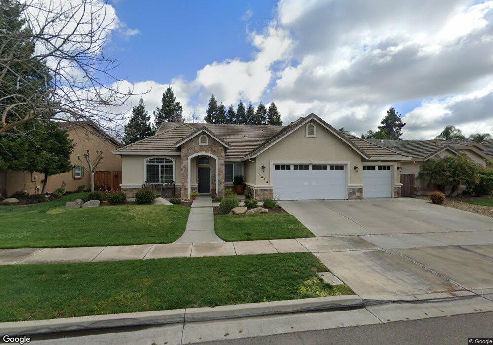
1363 Christopher Dr Merced, CA 95340
Estimated Value: $525,000 - $570,000
4
Beds
2
Baths
2,416
Sq Ft
$223/Sq Ft
Est. Value
About This Home
This home is located at 1363 Christopher Dr, Merced, CA 95340 and is currently estimated at $539,103, approximately $223 per square foot. 1363 Christopher Dr is a home located in Merced County with nearby schools including Allan Peterson Elementary School, Herbert H. Cruickshank Middle School, and El Capitan High School.
Ownership History
Date
Name
Owned For
Owner Type
Purchase Details
Closed on
Jun 29, 2007
Sold by
Cuttone Christopher J and Cuttone Merci Lynn
Bought by
Cuttone Christopher J and Cuttone Merci Lynn
Current Estimated Value
Purchase Details
Closed on
Aug 15, 2003
Sold by
Cuttone & Co
Bought by
Cuttone Christopher J
Purchase Details
Closed on
Aug 7, 2003
Sold by
Y B Real Estate Inc
Bought by
Cuttone & Co
Create a Home Valuation Report for This Property
The Home Valuation Report is an in-depth analysis detailing your home's value as well as a comparison with similar homes in the area
Purchase History
| Date | Buyer | Sale Price | Title Company |
|---|---|---|---|
| Cuttone Christopher J | -- | None Available | |
| Cuttone Christopher J | $270,000 | -- | |
| Cuttone & Co | -- | Transcounty Title Company |
Source: Public Records
Tax History
| Year | Tax Paid | Tax Assessment Tax Assessment Total Assessment is a certain percentage of the fair market value that is determined by local assessors to be the total taxable value of land and additions on the property. | Land | Improvement |
|---|---|---|---|---|
| 2025 | $4,225 | $383,869 | $127,953 | $255,916 |
| 2024 | $4,225 | $376,344 | $125,445 | $250,899 |
| 2023 | $4,187 | $368,966 | $122,986 | $245,980 |
| 2022 | $4,128 | $361,732 | $120,575 | $241,157 |
| 2021 | $4,136 | $354,640 | $118,211 | $236,429 |
| 2020 | $4,072 | $351,004 | $116,999 | $234,005 |
| 2019 | $4,025 | $344,122 | $114,705 | $229,417 |
| 2018 | $3,686 | $337,375 | $112,456 | $224,919 |
| 2017 | $3,796 | $330,760 | $110,251 | $220,509 |
| 2016 | $3,745 | $324,276 | $108,090 | $216,186 |
| 2015 | $3,671 | $319,406 | $106,467 | $212,939 |
| 2014 | $3,589 | $313,150 | $104,382 | $208,768 |
Source: Public Records
Map
Nearby Homes
- 1126 Sprig Ct
- 0 Dunn Rd Unit MC25278439
- 0 Dunn Rd Unit MC25278437
- 724 Robin Dr
- 1862 Dunn Rd
- 3563 Century Cir
- 978 Doe Ct
- 1143 Brownie Ct
- 591 Bobolink Ct Unit 2
- 692 Gateway Cir
- 1787 Edgewood Ct
- 3437 Cypress Point Dr
- 2009 Robin Hood Ln
- 3314 Robin Hood Ln
- 3345 Shamrock Place
- 3342 Banbury Ln
- 3338 Columbia Ave
- 3320 Banbury Ln
- 562 Sunset Dr
- 2367 Explorador Dr
- 1377 Christopher Dr
- 1355 Christopher Dr
- 1385 Christopher Dr
- 1346 Luke Dr
- 1362 Luke Dr
- 1374 Luke Dr
- 3917 White Dove Ave
- 1318 Luke Dr
- 1370 Christopher Dr
- 1391 Christopher Dr
- 1378 Christopher Dr
- 1366 Christopher Dr
- 3925 White Dove Ave
- 1382 Christopher Dr
- 1354 Christopher Dr
- 1346 Christopher Dr
- 1394 Christopher Dr
- 1338 Christopher Dr
- 3941 White Dove Ave
- 1326 Christopher Dr
Your Personal Tour Guide
Ask me questions while you tour the home.