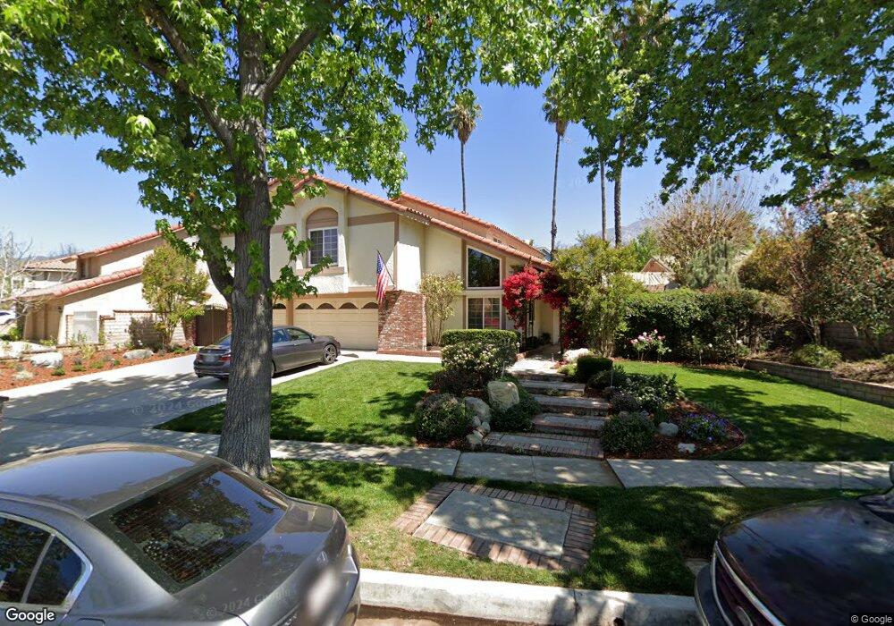
1365 Auburn St Upland, CA 91784
Estimated Value: $963,000 - $1,233,000
3
Beds
3
Baths
2,863
Sq Ft
$374/Sq Ft
Est. Value
About This Home
This home is located at 1365 Auburn St, Upland, CA 91784 and is currently estimated at $1,069,519, approximately $373 per square foot. 1365 Auburn St is a home located in San Bernardino County with nearby schools including Pepper Tree Elementary, Pioneer Junior High School, and Upland High School.
Ownership History
Date
Name
Owned For
Owner Type
Purchase Details
Closed on
Jun 1, 2016
Sold by
Carter Ralph Stephen
Bought by
The Carter Family Trust
Current Estimated Value
Home Financials for this Owner
Home Financials are based on the most recent Mortgage that was taken out on this home.
Original Mortgage
$317,000
Interest Rate
3.59%
Mortgage Type
New Conventional
Purchase Details
Closed on
Jan 31, 2013
Sold by
Carter Ralph Stephen
Bought by
Carter Ralph Stephen and Carter Deborah Denise
Home Financials for this Owner
Home Financials are based on the most recent Mortgage that was taken out on this home.
Original Mortgage
$301,620
Interest Rate
3.34%
Mortgage Type
New Conventional
Purchase Details
Closed on
Jul 27, 2012
Sold by
Carter R Stephen
Bought by
Carter Ralph Stephen and Carter Deborah Denise
Create a Home Valuation Report for This Property
The Home Valuation Report is an in-depth analysis detailing your home's value as well as a comparison with similar homes in the area
Home Values in the Area
Average Home Value in this Area
Purchase History
| Date | Buyer | Sale Price | Title Company |
|---|---|---|---|
| The Carter Family Trust | -- | Accommodation | |
| Carter Ralph Stephen | -- | Pacific Coast Title Company | |
| Carter Ralph Stephen | -- | Accommodation | |
| Carter Ralph Stephen | -- | First American Title Company | |
| Carter Ralph Stephen | -- | None Available |
Source: Public Records
Mortgage History
| Date | Status | Borrower | Loan Amount |
|---|---|---|---|
| Closed | Carter Ralph Stephen | $317,000 | |
| Closed | Carter Ralph Stephen | $301,620 |
Source: Public Records
Tax History
| Year | Tax Paid | Tax Assessment Tax Assessment Total Assessment is a certain percentage of the fair market value that is determined by local assessors to be the total taxable value of land and additions on the property. | Land | Improvement |
|---|---|---|---|---|
| 2025 | $6,519 | $595,223 | $162,334 | $432,889 |
| 2024 | $6,310 | $583,552 | $159,151 | $424,401 |
| 2023 | $6,215 | $572,109 | $156,030 | $416,079 |
| 2022 | $6,080 | $560,892 | $152,971 | $407,921 |
| 2021 | $6,072 | $549,895 | $149,972 | $399,923 |
| 2020 | $5,907 | $544,256 | $148,434 | $395,822 |
| 2019 | $5,885 | $533,585 | $145,524 | $388,061 |
| 2018 | $5,740 | $523,123 | $142,671 | $380,452 |
| 2017 | $5,574 | $512,866 | $139,874 | $372,992 |
| 2016 | $5,347 | $502,809 | $137,131 | $365,678 |
| 2015 | $5,224 | $495,256 | $135,071 | $360,185 |
| 2014 | $5,089 | $485,554 | $132,425 | $353,129 |
Source: Public Records
Map
Nearby Homes
- 1798 Wilson Ave
- 1238 Fairway Cir
- 1234 Fairway Cir
- 1243 Jacaranda Place
- 1739 Orangewood Ave
- 1640 Lakewood Ave
- 1931 Eloise Way
- 1613 Erin Ave
- 2062 Havenhurst Way
- 1671 N Rocky Rd
- 1647 Purple Heart Place
- 1328 Sunrise Cir S
- 1393 Sunrise Cir S
- 1214 Miller Ct
- 1520 Cantabria Place
- 779 Coral Tree Way
- 1496 Lemon Grove Dr
- 888 Via Maria
- 1267 Preston Ct
- 1669 N San Antonio Ave
- 1375 Auburn St
- 1821 Maywood Ct
- 1827 Maywood Ct
- 1831 Maywood Ct
- 1826 Lakewood Ave
- 1875 Maywood Ct
- 1814 Lakewood Ave
- 1360 Auburn St
- 1834 Lakewood Ave
- 1368 Auburn St
- 1350 Auburn St
- 1835 Maywood Ct
- 1340 Auburn St
- 1820 Maywood Ct
- 1826 Maywood Ct
- 1804 Lakewood Ave
- 1843 Maywood Ct
- 1838 Lakewood Ave
- 1823 Lakewood Ave
- 1330 Auburn St
Your Personal Tour Guide
Ask me questions while you tour the home.