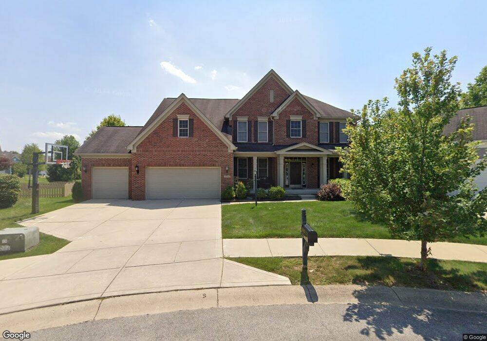
13660 Mallorn Cir Fishers, IN 46038
Estimated Value: $619,687 - $650,000
3
Beds
4
Baths
2,729
Sq Ft
$233/Sq Ft
Est. Value
About This Home
This home is located at 13660 Mallorn Cir, Fishers, IN 46038 and is currently estimated at $634,672, approximately $232 per square foot. 13660 Mallorn Cir is a home located in Hamilton County with nearby schools including Cumberland Road Elementary School, East Middle School, and Sand Creek Intermediate School.
Ownership History
Date
Name
Owned For
Owner Type
Purchase Details
Closed on
Dec 16, 2008
Sold by
The Estridge Group Inc
Bought by
Issak Mohamed and Issak Asha
Current Estimated Value
Home Financials for this Owner
Home Financials are based on the most recent Mortgage that was taken out on this home.
Original Mortgage
$299,800
Outstanding Balance
$197,413
Interest Rate
6.06%
Mortgage Type
Purchase Money Mortgage
Estimated Equity
$437,259
Purchase Details
Closed on
Sep 9, 2008
Sold by
Estridge Development Co Inc
Bought by
The Estridge Group Inc
Create a Home Valuation Report for This Property
The Home Valuation Report is an in-depth analysis detailing your home's value as well as a comparison with similar homes in the area
Home Values in the Area
Average Home Value in this Area
Purchase History
| Date | Buyer | Sale Price | Title Company |
|---|---|---|---|
| Issak Mohamed | -- | Chicago Title Masters | |
| The Estridge Group Inc | -- | None Available |
Source: Public Records
Mortgage History
| Date | Status | Borrower | Loan Amount |
|---|---|---|---|
| Open | Issak Mohamed | $299,800 |
Source: Public Records
Tax History Compared to Growth
Tax History
| Year | Tax Paid | Tax Assessment Tax Assessment Total Assessment is a certain percentage of the fair market value that is determined by local assessors to be the total taxable value of land and additions on the property. | Land | Improvement |
|---|---|---|---|---|
| 2024 | $5,833 | $537,700 | $86,800 | $450,900 |
| 2023 | $5,833 | $503,800 | $86,800 | $417,000 |
| 2022 | $5,604 | $465,300 | $86,800 | $378,500 |
| 2021 | $5,044 | $418,300 | $86,800 | $331,500 |
| 2020 | $5,145 | $422,100 | $86,800 | $335,300 |
| 2019 | $5,085 | $417,200 | $78,200 | $339,000 |
| 2018 | $5,144 | $420,900 | $78,200 | $342,700 |
| 2017 | $4,791 | $399,100 | $78,200 | $320,900 |
| 2016 | $4,558 | $380,100 | $76,700 | $303,400 |
| 2014 | $4,175 | $383,800 | $79,400 | $304,400 |
| 2013 | $4,175 | $387,000 | $79,400 | $307,600 |
Source: Public Records
Map
Nearby Homes
- 11069 Chandler Way
- 11090 Sanders Dr
- 11141 Craycroft Ct
- 13281 Middlewood Ln
- 13763 Meadow Lake Dr
- 10414 Bicknell Cir
- 10523 Hollowood Ct
- 13703 Van Buren Place
- 10713 Summerwood Ln
- 10343 Waveland Cir
- 10175 Pamona Ct
- 11581 Beardsley Way
- 10671 Pleasant View Ln
- 13125 Zinfandel Place
- 10270 Apple Blossom Cir
- 10873 Glazer Way
- 13855 Boulder Canyon Dr
- 13048 Ross Crossing
- 14041 Mimosa Ct
- 14243 Holly Berry Cir
- 10946 Blooming Orchard Dr
- 13670 Mallorn Cir
- 13679 Mallorn Cir
- 10916 Blooming Orchard Dr
- 13658 Blooming Orchard Dr
- 10896 Blooming Orchard Dr
- 13668 Blooming Orchard Dr
- 13680 Mallorn Cir
- 13689 Mallorn Cir
- 10872 Blooming Orchard Dr
- 13678 Blooming Orchard Dr
- 13699 Mallorn Cir
- 13082 Heatherfield Dr
- 10965 Blooming Orchard Dr
- 10856 Blooming Orchard Dr
- 13698 Blooming Orchard Dr
- 10945 Blooming Orchard Dr
- 10925 Blooming Orchard Dr
- 13688 Blooming Orchard Dr
- 13704 Heatherfield Dr