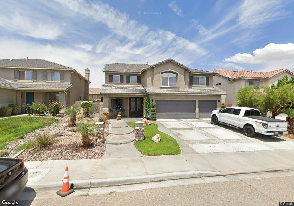
13660 Silversand St Victorville, CA 92394
Mesa Linda NeighborhoodEstimated Value: $529,000 - $595,000
5
Beds
3
Baths
3,682
Sq Ft
$152/Sq Ft
Est. Value
About This Home
This home is located at 13660 Silversand St, Victorville, CA 92394 and is currently estimated at $559,303, approximately $151 per square foot. 13660 Silversand St is a home located in San Bernardino County with nearby schools including West Creek Elementary School and Adelanto High School.
Ownership History
Date
Name
Owned For
Owner Type
Purchase Details
Closed on
Apr 19, 2011
Sold by
Chao Frank
Bought by
Chao Frank and Chao Vanessa E
Current Estimated Value
Purchase Details
Closed on
May 28, 2004
Sold by
Kb Home Greater Los Angeles Inc
Bought by
Chao Frank and Chao Vanessa E
Home Financials for this Owner
Home Financials are based on the most recent Mortgage that was taken out on this home.
Original Mortgage
$305,700
Interest Rate
5.95%
Mortgage Type
Purchase Money Mortgage
Create a Home Valuation Report for This Property
The Home Valuation Report is an in-depth analysis detailing your home's value as well as a comparison with similar homes in the area
Home Values in the Area
Average Home Value in this Area
Purchase History
| Date | Buyer | Sale Price | Title Company |
|---|---|---|---|
| Chao Frank | -- | None Available | |
| Chao Frank | $340,000 | Fidelity-Riverside |
Source: Public Records
Mortgage History
| Date | Status | Borrower | Loan Amount |
|---|---|---|---|
| Previous Owner | Chao Frank | $305,700 |
Source: Public Records
Tax History Compared to Growth
Tax History
| Year | Tax Paid | Tax Assessment Tax Assessment Total Assessment is a certain percentage of the fair market value that is determined by local assessors to be the total taxable value of land and additions on the property. | Land | Improvement |
|---|---|---|---|---|
| 2025 | $5,691 | $504,491 | $69,697 | $434,794 |
| 2024 | $5,691 | $494,599 | $68,330 | $426,269 |
| 2023 | $5,634 | $484,901 | $66,990 | $417,911 |
| 2022 | $5,529 | $475,393 | $65,676 | $409,717 |
| 2021 | $5,128 | $406,000 | $81,000 | $325,000 |
| 2020 | $4,803 | $383,100 | $76,200 | $306,900 |
| 2019 | $4,725 | $372,000 | $74,000 | $298,000 |
| 2018 | $4,589 | $352,700 | $44,100 | $308,600 |
| 2017 | $4,234 | $328,100 | $41,000 | $287,100 |
| 2016 | $3,928 | $303,800 | $38,000 | $265,800 |
| 2015 | $3,531 | $280,000 | $35,000 | $245,000 |
| 2014 | $2,988 | $216,200 | $23,000 | $193,200 |
Source: Public Records
Map
Nearby Homes
- 13651 Gold Stone Place
- 13551 Western Meadows Ln
- 14766 Shetland Ct
- 15121 Sorrel Rd
- 15203 Zircon Dr
- 14964 Butler Peak Ct
- 15184 Brucite Rd
- 15255 Sunray Ct
- Residence 1310 Plan at Dawson Pointe at West Creek
- Residence 1583 Plan at Dawson Pointe at West Creek
- Residence 2057 Plan at Dawson Pointe at West Creek
- Residence 2260 Plan at Dawson Pointe at West Creek
- Residence 1816 Plan at Dawson Pointe at West Creek
- 13720 Dove Ct
- 14780 Butterfly Ct
- 14991 Mandalay Ln
- 13971 Clydesdale Run Ln
- 13986 Estate Way
- 14115 Buckskin Ct
- 14117 Gopher Canyon Rd
- 13650 Silversand St
- 13670 Silversand St
- 13640 Silversand St
- 13653 Copper St
- 13647 Copper St
- 13663 Copper St
- 13637 Copper St
- 13663 Silversand St
- 13630 Silversand St
- 13651 Silversand St
- 13673 Silversand St
- 13627 Copper St
- 13639 Silversand St
- 14941 Stone Dr
- 14951 Stone Dr
- 14931 Stone Dr
- 13620 Silversand St
- 14961 Stone Dr
- 13683 Silversand St
- 13629 Silversand St