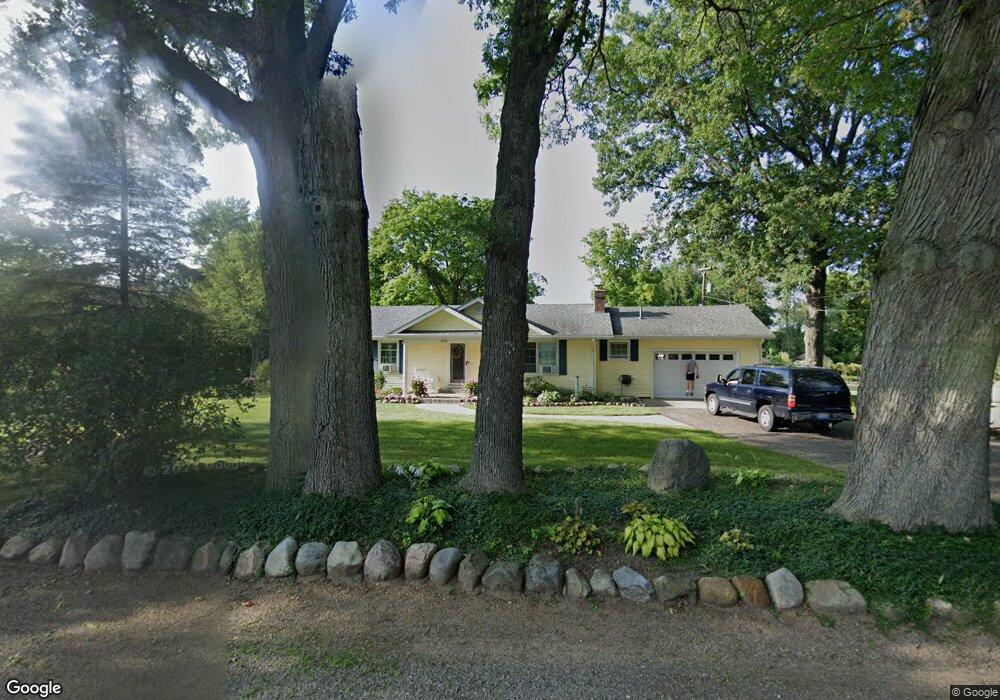
13691 A Dr N Ceresco, MI 49033
Estimated Value: $255,781 - $350,000
3
Beds
1
Bath
1,728
Sq Ft
$172/Sq Ft
Est. Value
About This Home
This home is located at 13691 A Dr N, Ceresco, MI 49033 and is currently estimated at $296,695, approximately $171 per square foot. 13691 A Dr N is a home located in Calhoun County with nearby schools including Harrington Elementary School, Marshall High School, and Presbyterian Center for Children.
Ownership History
Date
Name
Owned For
Owner Type
Purchase Details
Closed on
Nov 18, 2004
Sold by
Pell Josephine E and Pell David R
Bought by
Herman Bruce E and Herman Cynthia L
Current Estimated Value
Home Financials for this Owner
Home Financials are based on the most recent Mortgage that was taken out on this home.
Original Mortgage
$93,600
Outstanding Balance
$46,678
Interest Rate
5.77%
Mortgage Type
Purchase Money Mortgage
Estimated Equity
$250,017
Purchase Details
Closed on
Apr 28, 1995
Sold by
Slater Allen and Auer Kristi
Bought by
Pell Josephine E
Purchase Details
Closed on
Aug 1, 1992
Create a Home Valuation Report for This Property
The Home Valuation Report is an in-depth analysis detailing your home's value as well as a comparison with similar homes in the area
Home Values in the Area
Average Home Value in this Area
Purchase History
| Date | Buyer | Sale Price | Title Company |
|---|---|---|---|
| Herman Bruce E | $120,000 | Chicago Title Insurance Co | |
| Pell Josephine E | $83,000 | -- | |
| -- | $73,000 | -- |
Source: Public Records
Mortgage History
| Date | Status | Borrower | Loan Amount |
|---|---|---|---|
| Open | Herman Bruce E | $93,600 |
Source: Public Records
Tax History Compared to Growth
Tax History
| Year | Tax Paid | Tax Assessment Tax Assessment Total Assessment is a certain percentage of the fair market value that is determined by local assessors to be the total taxable value of land and additions on the property. | Land | Improvement |
|---|---|---|---|---|
| 2025 | -- | $116,700 | $0 | $0 |
| 2024 | $1,581 | $107,500 | $0 | $0 |
| 2023 | $2,685 | $98,300 | $0 | $0 |
| 2022 | $2,685 | $88,600 | $0 | $0 |
| 2021 | $2,603 | $83,600 | $0 | $0 |
| 2020 | $2,571 | $77,500 | $0 | $0 |
| 2019 | $0 | $72,500 | $0 | $0 |
| 2018 | $0 | $70,300 | $4,900 | $65,400 |
| 2017 | $0 | $67,100 | $0 | $0 |
| 2016 | $0 | $66,800 | $0 | $0 |
| 2015 | -- | $65,400 | $13,428 | $51,972 |
| 2014 | -- | $65,300 | $13,428 | $51,872 |
Source: Public Records
Map
Nearby Homes
- 11253 Wildwood Dr
- 275 Battle Creek St
- 0 15 1 2 Mile Rd Unit 25024661
- 216 Winston Dr
- 218 Winston Dr
- 14880 C Dr S
- 11506 11 Mile Rd
- 119 Greenfield Blvd
- 0 N F Dr Unit 23021090
- 732 W Hanover St
- 734 Verona Rd
- 15627 13 Mile Rd
- 1049 Rebecca St Unit 3
- 1025 Rebecca St Unit 15
- 1029 Rebecca St Unit 13
- 1048 Rebecca St Unit 19
- 1050 Rebecca St Unit 18
- 217 W Hughes St
- V/L Cedar Lake
- 605 Turquoise Trail