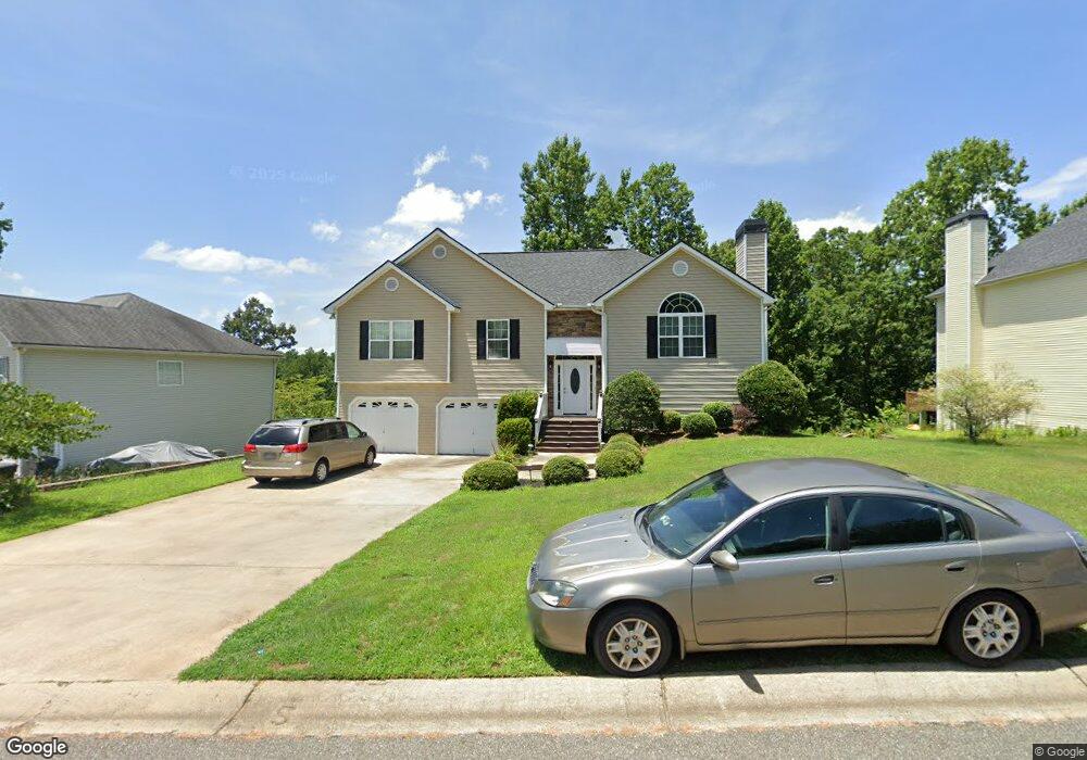
137 Sable Trace Trail Acworth, GA 30102
Oak Grove NeighborhoodEstimated Value: $417,243 - $436,000
3
Beds
2
Baths
2,414
Sq Ft
$177/Sq Ft
Est. Value
About This Home
This home is located at 137 Sable Trace Trail, Acworth, GA 30102 and is currently estimated at $426,622, approximately $176 per square foot. 137 Sable Trace Trail is a home located in Cherokee County with nearby schools including Oak Grove Elementary School, E. T. Booth Middle School, and Etowah High School.
Ownership History
Date
Name
Owned For
Owner Type
Purchase Details
Closed on
Mar 29, 2005
Sold by
Dixie Developing & Building Inc
Bought by
Dorleus Jean and Dorleus Marie
Current Estimated Value
Home Financials for this Owner
Home Financials are based on the most recent Mortgage that was taken out on this home.
Original Mortgage
$166,500
Outstanding Balance
$83,905
Interest Rate
5.62%
Mortgage Type
New Conventional
Estimated Equity
$342,717
Create a Home Valuation Report for This Property
The Home Valuation Report is an in-depth analysis detailing your home's value as well as a comparison with similar homes in the area
Home Values in the Area
Average Home Value in this Area
Purchase History
| Date | Buyer | Sale Price | Title Company |
|---|---|---|---|
| Dorleus Jean | $185,000 | -- |
Source: Public Records
Mortgage History
| Date | Status | Borrower | Loan Amount |
|---|---|---|---|
| Open | Dorleus Jean | $166,500 |
Source: Public Records
Tax History
| Year | Tax Paid | Tax Assessment Tax Assessment Total Assessment is a certain percentage of the fair market value that is determined by local assessors to be the total taxable value of land and additions on the property. | Land | Improvement |
|---|---|---|---|---|
| 2025 | $886 | $165,320 | $34,000 | $131,320 |
| 2024 | $862 | $166,200 | $34,000 | $132,200 |
| 2023 | $730 | $168,440 | $34,000 | $134,440 |
| 2022 | $792 | $131,480 | $32,000 | $99,480 |
| 2021 | $2,805 | $106,720 | $24,000 | $82,720 |
| 2020 | $2,644 | $99,680 | $22,000 | $77,680 |
| 2019 | $2,511 | $93,960 | $22,000 | $71,960 |
| 2018 | $2,302 | $84,440 | $19,200 | $65,240 |
| 2017 | $2,293 | $208,300 | $19,200 | $64,120 |
| 2016 | $2,119 | $187,700 | $19,200 | $55,880 |
| 2015 | $1,897 | $167,100 | $15,200 | $51,640 |
| 2014 | $1,596 | $141,200 | $13,000 | $43,480 |
Source: Public Records
Map
Nearby Homes
- 170 Sable Trace Trail
- 736 Coventry Cove Way
- 740 Coventry Cove Way
- 321 Brighton Bend Ln
- 744 Coventry Cove Way
- 325 Brighton Bend Ln
- 748 Coventry Cove Way
- 752 Coventry Cove Way
- 333 Brighton Bend Ln
- 756 Coventry Cove Way
- 337 Brighton Bend Ln
- 341 Brighton Bend Ln
- 3106 Cambridge Mill St
- 3102 Cambridge Mill St
- 307 Queensbury Walk
- 585 Lee Dr
- 6390 Woodstock Rd
- 1037 Queensbury Run
- 1030 Queensbury Run Unit 1
- 204 Queensbury Ct
- 135 Sable Trace Trail
- 139 Sable Trace Trail
- 162 Sable Trace Trail
- 133 Sable Trace Trail
- 141 Sable Trace Trail
- 164 Sable Trace Trail
- 160 Sable Trace Trail
- 131 Sable Trace Trail
- 166 Sable Trace Trail
- 158 Sable Trace Trail
- 143 Sable Trace Trail
- 145 Sable Trace Trail
- 145 Sable Trace Trail
- 129 Sable Trace Trail
- 803 Sable Trace Hollow
- 156 Sable Trace Trail
- 802 Sable Trace Hollow
- 168 Sable Trace Trail
- 168 Sable Trace Trail Unit 164
- 168 Sable Trace Trail
Your Personal Tour Guide
Ask me questions while you tour the home.