Estimated Value: $248,000 - $328,000
4
Beds
3
Baths
2,188
Sq Ft
$139/Sq Ft
Est. Value
About This Home
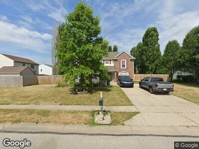
This home is located at 1374 Bearsden Dr, Avon, IN 46123 and is currently estimated at $304,732, approximately $139 per square foot. 1374 Bearsden Dr is a home located in Hendricks County with nearby schools including White Oak Elementary School, Sycamore Elementary School, and Avon Middle School North.
Ownership History
Date
Name
Owned For
Owner Type
Purchase Details
Closed on
Feb 2, 2009
Sold by
U S Bank National Association
Bought by
Sherwood Donn A and Sherwood Ashlee L
Current Estimated Value
Home Financials for this Owner
Home Financials are based on the most recent Mortgage that was taken out on this home.
Original Mortgage
$120,391
Interest Rate
5.22%
Mortgage Type
VA
Purchase Details
Closed on
Sep 18, 2008
Sold by
Guerra Kathy
Bought by
Us Bank Na
Create a Home Valuation Report for This Property
The Home Valuation Report is an in-depth analysis detailing your home's value as well as a comparison with similar homes in the area
Home Values in the Area
Average Home Value in this Area
Purchase History
| Date | Buyer | Sale Price | Title Company |
|---|---|---|---|
| Sherwood Donn A | -- | Security Title Services Llc | |
| Us Bank Na | $130,200 | None Available |
Source: Public Records
Mortgage History
| Date | Status | Borrower | Loan Amount |
|---|---|---|---|
| Open | Sherwood Donn A | $86,000 | |
| Closed | Sherwood Donn A | $120,446 | |
| Previous Owner | Sherwood Donn A | $120,391 |
Source: Public Records
Tax History Compared to Growth
Tax History
| Year | Tax Paid | Tax Assessment Tax Assessment Total Assessment is a certain percentage of the fair market value that is determined by local assessors to be the total taxable value of land and additions on the property. | Land | Improvement |
|---|---|---|---|---|
| 2024 | $2,506 | $224,200 | $44,900 | $179,300 |
| 2023 | $2,310 | $208,000 | $40,800 | $167,200 |
| 2022 | $2,279 | $203,800 | $40,800 | $163,000 |
| 2021 | $2,064 | $184,500 | $40,800 | $143,700 |
| 2020 | $1,918 | $170,600 | $40,800 | $129,800 |
| 2019 | $1,786 | $157,600 | $38,100 | $119,500 |
| 2018 | $1,805 | $156,700 | $38,100 | $118,600 |
| 2017 | $1,463 | $146,300 | $36,300 | $110,000 |
| 2016 | $1,444 | $144,400 | $36,300 | $108,100 |
| 2014 | $1,392 | $139,200 | $33,800 | $105,400 |
Source: Public Records
Map
Nearby Homes
- 1408 Snead Cir
- 8287 Falkirk Dr
- 8727 Redditch Dr
- 1773 Winchester Blvd
- 948 Kitner Ave
- 1843 Winchester Blvd
- 883 Halyard Dr
- 1829 Archbury Dr
- 8178 Eskerban Dr
- 804 Seabreeze Dr
- 1839 Silverton Dr
- 764 Port Dr
- 816 N County Road 900 E
- 2075 Longford Ln
- 7939 Sharon Dr
- 9106 Hedley Way E
- 8106 Captain Dr
- 8684 Captain Dr
- 2093 Autumn Faith Way
- 1289 Sunset Blvd
- 1374 Bearsden Dr
- 1392 Bearsden Dr
- 8450 Falkirk Dr
- 8432 Falkirk Dr
- 1391 Snead Cir
- 1399 Snead Cir
- 8420 Falkirk Dr
- 1406 Bearsden Dr
- 1373 Bearsden Dr
- 1391 Bearsden Dr
- 1355 Bearsden Dr
- 1324 Bearsden Cir
- 8404 Falkirk Dr
- 1405 Bearsden Dr
- 1415 Snead Cir
- 1388 Snead Cir
- 1422 Bearsden Dr
- 1325 Kinross Dr
- 1355 Beardsden Cir
- 1355 Bearsden Cir