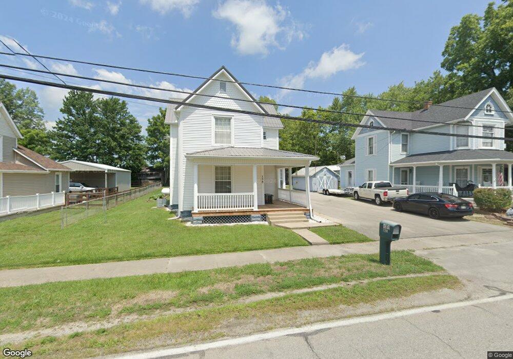
138 Maple Ave Sardinia, OH 45171
Estimated Value: $154,000 - $245,000
3
Beds
1
Bath
1,652
Sq Ft
$115/Sq Ft
Est. Value
About This Home
This home is located at 138 Maple Ave, Sardinia, OH 45171 and is currently estimated at $190,224, approximately $115 per square foot. 138 Maple Ave is a home located in Brown County with nearby schools including Sardinia Elementary School, Russellville Elementary School, and Eastern Middle School.
Ownership History
Date
Name
Owned For
Owner Type
Purchase Details
Closed on
Oct 29, 2019
Sold by
Estate Of Donald C Vance
Bought by
Vance Carolyn A
Current Estimated Value
Purchase Details
Closed on
May 31, 2019
Sold by
Declaire Daniel D and Declaire Gail N
Bought by
Logan Patrick
Home Financials for this Owner
Home Financials are based on the most recent Mortgage that was taken out on this home.
Original Mortgage
$78,551
Interest Rate
4.1%
Mortgage Type
FHA
Create a Home Valuation Report for This Property
The Home Valuation Report is an in-depth analysis detailing your home's value as well as a comparison with similar homes in the area
Home Values in the Area
Average Home Value in this Area
Purchase History
| Date | Buyer | Sale Price | Title Company |
|---|---|---|---|
| Vance Carolyn A | -- | None Available | |
| Logan Patrick | $80,000 | Chase Legal Title Llc |
Source: Public Records
Mortgage History
| Date | Status | Borrower | Loan Amount |
|---|---|---|---|
| Previous Owner | Logan Patrick | $78,551 |
Source: Public Records
Tax History
| Year | Tax Paid | Tax Assessment Tax Assessment Total Assessment is a certain percentage of the fair market value that is determined by local assessors to be the total taxable value of land and additions on the property. | Land | Improvement |
|---|---|---|---|---|
| 2024 | $1,283 | $47,770 | $3,100 | $44,670 |
| 2023 | $1,312 | $36,940 | $2,580 | $34,360 |
| 2022 | $1,048 | $36,940 | $2,580 | $34,360 |
| 2021 | $1,039 | $36,940 | $2,580 | $34,360 |
| 2020 | $896 | $32,130 | $2,250 | $29,880 |
| 2019 | $890 | $32,130 | $2,250 | $29,880 |
| 2018 | $883 | $32,130 | $2,250 | $29,880 |
| 2017 | $706 | $27,800 | $2,470 | $25,330 |
| 2016 | $707 | $27,800 | $2,470 | $25,330 |
| 2015 | $738 | $27,800 | $2,470 | $25,330 |
| 2014 | $738 | $27,580 | $2,250 | $25,330 |
| 2013 | $736 | $27,580 | $2,250 | $25,330 |
Source: Public Records
Map
Nearby Homes
- 113 Liberty Ln
- 115 Cherry St
- 173 Winchester St
- 20 W Mohican Cove
- 1656 S Waynoka
- 6 Mohican Cove
- 476 S Waynoka
- 2241 E Waynoka
- 7348 Tricounty Hwy Unit LOT 39
- 1 Duncanson Rd
- 874 Waynoka Dr
- 0 Horse Shoe Dr Unit 1857810
- 121 Mae St
- 2 Duncanson Rd
- 689 Duncanson Rd
- 7716 Tri County Hwy
- 13178 Stieman Rd
- 0 Duncanson Rd Unit 24557375
- 0 Duncanson Rd Unit 24555971
- 5685 Tri County Hwy
Your Personal Tour Guide
Ask me questions while you tour the home.