Estimated Value: $238,000 - $301,065
2
Beds
1
Bath
1,600
Sq Ft
$175/Sq Ft
Est. Value
About This Home
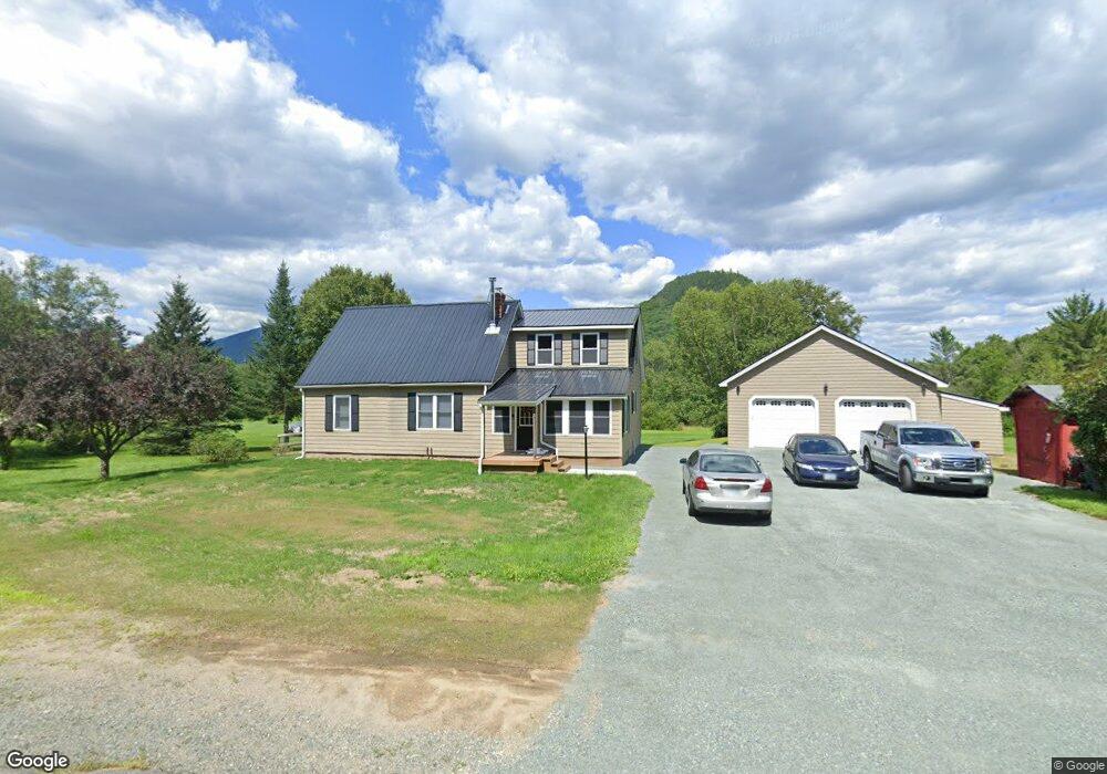
This home is located at 1380 Stark Hwy, Stark, NH 03582 and is currently estimated at $280,016, approximately $175 per square foot. 1380 Stark Hwy is a home located in Coos County.
Ownership History
Date
Name
Owned For
Owner Type
Purchase Details
Closed on
Dec 28, 2020
Sold by
Cowie Margaret
Bought by
Depino Ralph
Current Estimated Value
Home Financials for this Owner
Home Financials are based on the most recent Mortgage that was taken out on this home.
Original Mortgage
$159,914
Outstanding Balance
$142,699
Interest Rate
2.7%
Mortgage Type
New Conventional
Estimated Equity
$137,317
Purchase Details
Closed on
May 17, 2006
Sold by
Mize Catherine M
Bought by
Cowie Margaret and Cowie William
Home Financials for this Owner
Home Financials are based on the most recent Mortgage that was taken out on this home.
Original Mortgage
$43,633
Interest Rate
6.42%
Purchase Details
Closed on
Nov 2, 1999
Sold by
King Wayne
Bought by
Mize Catherine M
Home Financials for this Owner
Home Financials are based on the most recent Mortgage that was taken out on this home.
Original Mortgage
$48,000
Interest Rate
7.78%
Create a Home Valuation Report for This Property
The Home Valuation Report is an in-depth analysis detailing your home's value as well as a comparison with similar homes in the area
Home Values in the Area
Average Home Value in this Area
Purchase History
| Date | Buyer | Sale Price | Title Company |
|---|---|---|---|
| Depino Ralph | $187,000 | None Available | |
| Cowie Margaret | $80,000 | -- | |
| Mize Catherine M | $55,000 | -- |
Source: Public Records
Mortgage History
| Date | Status | Borrower | Loan Amount |
|---|---|---|---|
| Open | Depino Ralph | $159,914 | |
| Previous Owner | Mize Catherine M | $43,633 | |
| Previous Owner | Mize Catherine M | $48,000 |
Source: Public Records
Tax History Compared to Growth
Tax History
| Year | Tax Paid | Tax Assessment Tax Assessment Total Assessment is a certain percentage of the fair market value that is determined by local assessors to be the total taxable value of land and additions on the property. | Land | Improvement |
|---|---|---|---|---|
| 2024 | $2,856 | $263,013 | $121,713 | $141,300 |
| 2023 | $2,939 | $141,837 | $50,637 | $91,200 |
| 2022 | $1,903 | $116,328 | $51,028 | $65,300 |
| 2021 | $2,317 | $116,324 | $51,024 | $65,300 |
| 2020 | $2,097 | $116,513 | $51,213 | $65,300 |
| 2019 | $2,104 | $116,460 | $51,160 | $65,300 |
| 2018 | $2,112 | $117,612 | $42,912 | $74,700 |
| 2017 | $2,137 | $117,505 | $42,805 | $74,700 |
| 2016 | $2,046 | $117,458 | $42,758 | $74,700 |
| 2015 | $1,997 | $117,425 | $42,725 | $74,700 |
| 2014 | $2,052 | $117,417 | $42,717 | $74,700 |
| 2013 | $1,692 | $96,808 | $43,608 | $53,200 |
Source: Public Records
Map
Nearby Homes
- 238 Northside Rd
- 750 Percy Rd
- 388 Percy Rd
- 338 Percy Rd
- 112 Normand Rd
- 1435 Lost Nation Rd
- 68 Short Rd
- 406 New Hampshire 110
- 13 Hillside Ave
- 41 Crow Hill St
- 18 State St
- 38 Riverside Dr
- 50 Church St
- 53 Montgomery Rd
- 00 Bell Hill Rd
- 102 Hillside Ave
- 88 State St
- 00 Mountain View Rd
- 0 Mountain View Rd
- 413 Lancaster Rd
- 1380 Stark Hwy Unit Map203 L001
- 1412 Stark Hwy
- 1356 Stark Hwy
- 0 New Hampshire 110
- 42 Dingman Rd
- 1447 Stark Hwy
- 148 Northside Rd
- 17 Dingman Rd
- 7 Town Garage Rd
- 214 Northside Rd
- 1321 Stark Hwy
- 41-41.1 Millbrook Rd
- 220 Northside Rd
- 24 Town Garage Rd
- 9 Town Garage Rd
- 1516 Stark Hwy
- 1256 Stark Hwy
- 0 Jenkins Rd Unit 4235613
- 0 Jenkins Rd Unit 4143931
- 8 Jenkins Rd