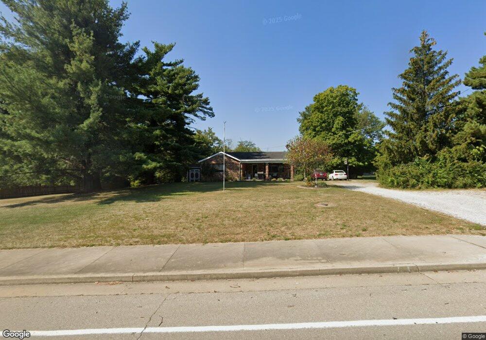
1383 N Bend Rd Hebron, KY 41048
Estimated Value: $266,000 - $313,000
3
Beds
2
Baths
1,215
Sq Ft
$237/Sq Ft
Est. Value
About This Home
This home is located at 1383 N Bend Rd, Hebron, KY 41048 and is currently estimated at $287,877, approximately $236 per square foot. 1383 N Bend Rd is a home located in Boone County with nearby schools including Thornwilde Elementary School, Conner Middle School, and Conner High School.
Ownership History
Date
Name
Owned For
Owner Type
Purchase Details
Closed on
Dec 19, 2014
Sold by
Barth Carol Suhre and Barth Christopher D
Bought by
Lowry Linda
Current Estimated Value
Home Financials for this Owner
Home Financials are based on the most recent Mortgage that was taken out on this home.
Original Mortgage
$142,857
Outstanding Balance
$109,238
Interest Rate
4.03%
Mortgage Type
New Conventional
Estimated Equity
$178,639
Purchase Details
Closed on
May 15, 1997
Sold by
Dolwick Vera A
Bought by
East Kentucky Power Cooperative Inc
Create a Home Valuation Report for This Property
The Home Valuation Report is an in-depth analysis detailing your home's value as well as a comparison with similar homes in the area
Home Values in the Area
Average Home Value in this Area
Purchase History
We collect this data history from publicly available records. To have your information removed, we recommend requesting removal directly through your county’s website.
| Date | Buyer | Sale Price | Title Company |
|---|---|---|---|
| Lowry Linda | $140,000 | None Available | |
| East Kentucky Power Cooperative Inc | $6,000 | -- |
Source: Public Records
Mortgage History
We collect this data history from publicly available records. To have your information removed, we recommend requesting removal directly through your county’s website.
| Date | Status | Borrower | Loan Amount |
|---|---|---|---|
| Open | Lowry Linda | $142,857 |
Source: Public Records
Tax History
| Year | Tax Paid | Tax Assessment Tax Assessment Total Assessment is a certain percentage of the fair market value that is determined by local assessors to be the total taxable value of land and additions on the property. | Land | Improvement |
|---|---|---|---|---|
| 2025 | $1,926 | $175,000 | $40,000 | $135,000 |
| 2024 | $1,709 | $157,300 | $25,000 | $132,300 |
| 2023 | $1,680 | $157,300 | $25,000 | $132,300 |
| 2022 | $1,687 | $157,300 | $25,000 | $132,300 |
| 2021 | $1,760 | $157,300 | $25,000 | $132,300 |
| 2020 | $1,527 | $140,000 | $10,000 | $130,000 |
| 2019 | $1,539 | $140,000 | $10,000 | $130,000 |
| 2018 | $1,590 | $140,000 | $10,000 | $130,000 |
| 2017 | $1,526 | $140,000 | $10,000 | $130,000 |
| 2015 | $1,515 | $140,000 | $10,000 | $130,000 |
| 2013 | -- | $125,000 | $125,000 | $0 |
Source: Public Records
Map
Nearby Homes
- 1580 Brenden Ct
- 1551 Brenden Ct
- 1543 Brenden Ct
- 1547 Brenden Ct
- 1540 Brenden Ct
- 1530 Brenden Ct
- 1510 Brenden Ct
- 2432 Rivers Pointe Dr
- 1 Rivers Pointe Dr
- 1748 Ledgestone Way
- 1745 Ledgestone Way
- 1350 Eagle View Dr
- 2053 Wedgewood Ln
- 2177 Treetop Ln
- 2034 Wedgewood Ln
- 1709 Ledgestone Way
- 1514 Crystal Rim Ct
- 1506 Crystal Rim Ct
- 2189 Treetop Ln
- 1500 Crystal Rim Ct
- 2035 Treetop Ln
- 2035 Treetop Ln Unit 1
- 2043 Treetop Ln
- 1407 N Bend Rd
- 1330 N Bend Rd
- 2049 Treetop Ln
- 1417 N Bend Rd
- 1417 N Bend Rd
- 2038 Treetop Ln
- 2038 Treetop Ln Unit 3
- 2055 Treetop Ln
- 2032 Treetop Ln
- 2023 Sand Run Rd
- 2031 Windsong Way
- 2035 Windsong Way
- 2027 Windsong Way
- 1979 Stahl Rd
- 2021 Windsong Way
- 1595 Windsong Way
- 2039 Windsong Way
Your Personal Tour Guide
Ask me questions while you tour the home.