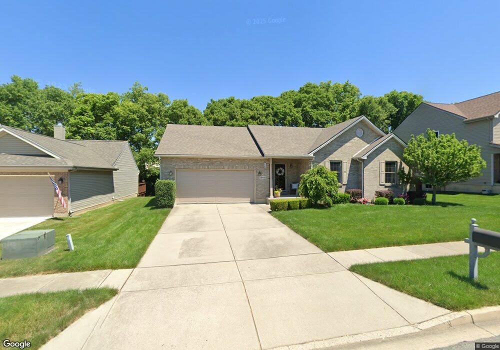
1385 Brookstone Dr Fairborn, OH 45324
Estimated Value: $294,425 - $323,000
3
Beds
3
Baths
1,469
Sq Ft
$214/Sq Ft
Est. Value
About This Home
This home is located at 1385 Brookstone Dr, Fairborn, OH 45324 and is currently estimated at $314,606, approximately $214 per square foot. 1385 Brookstone Dr is a home located in Greene County with nearby schools including Fairborn Primary School, Fairborn Intermediate School, and Fairborn Middle School.
Ownership History
Date
Name
Owned For
Owner Type
Purchase Details
Closed on
Jun 13, 2003
Sold by
Conley Andrew J and Conley Susan M
Bought by
Hopkins Mark S and Hopkins Gail L
Current Estimated Value
Home Financials for this Owner
Home Financials are based on the most recent Mortgage that was taken out on this home.
Original Mortgage
$124,000
Outstanding Balance
$51,229
Interest Rate
5.71%
Mortgage Type
Unknown
Estimated Equity
$263,377
Purchase Details
Closed on
Jul 18, 2002
Sold by
Jack Conley Homes Inc
Bought by
Conley Andrew J
Create a Home Valuation Report for This Property
The Home Valuation Report is an in-depth analysis detailing your home's value as well as a comparison with similar homes in the area
Home Values in the Area
Average Home Value in this Area
Purchase History
| Date | Buyer | Sale Price | Title Company |
|---|---|---|---|
| Hopkins Mark S | $162,000 | -- | |
| Conley Andrew J | $31,600 | -- |
Source: Public Records
Mortgage History
| Date | Status | Borrower | Loan Amount |
|---|---|---|---|
| Open | Hopkins Mark S | $124,000 |
Source: Public Records
Tax History
| Year | Tax Paid | Tax Assessment Tax Assessment Total Assessment is a certain percentage of the fair market value that is determined by local assessors to be the total taxable value of land and additions on the property. | Land | Improvement |
|---|---|---|---|---|
| 2025 | $3,728 | $79,110 | $15,880 | $63,230 |
| 2024 | $3,728 | $79,110 | $15,880 | $63,230 |
| 2023 | $3,699 | $79,110 | $15,880 | $63,230 |
| 2022 | $3,289 | $59,160 | $13,230 | $45,930 |
| 2021 | $3,338 | $59,160 | $13,230 | $45,930 |
| 2020 | $3,355 | $59,160 | $13,230 | $45,930 |
| 2019 | $3,122 | $55,210 | $11,030 | $44,180 |
| 2018 | $3,155 | $55,210 | $11,030 | $44,180 |
| 2017 | $3,087 | $55,210 | $11,030 | $44,180 |
| 2016 | $3,087 | $54,050 | $11,030 | $43,020 |
| 2015 | $2,940 | $54,050 | $11,030 | $43,020 |
| 2014 | $2,841 | $54,050 | $11,030 | $43,020 |
Source: Public Records
Map
Nearby Homes
- 1121 Whitetail Dr
- 1200 Whitetail Dr
- 1105 Windsong Trail
- 2549 Fawn Dr
- 00 Trebein Rd
- 1010 Brehm Blvd
- 1840 Spring Ridge Ct
- 1788 Fawnwood Ct
- Lot 1 Trebein Rd
- 1494 Indigo Dr
- 1183 Brehm Blvd
- 1155 Elloway Place
- 630 Hidden Valley Ct
- 1634 Arden Bend
- 1622 Arden Bend
- 479 Park Hills Crossing
- 474 Kalynn Cir
- 474 Kalynn Cir Unit 19
- 482 Kalynn Cir Unit 18
- 444 Park Hills Crossing Unit 54
- 1375 Brookstone Dr
- 2256 Trebein Rd
- 1369 Brookstone Dr
- 2257 Talbot Ct
- 1397 Brookstone Dr
- 2302 Spyglass Ct
- 2253 Talbot Ct
- 2303 Spyglass Ct
- 1359 Brookstone Dr
- 2306 Spyglass Ct
- 2301 Watchtower Ln
- 1401 Brookstone Dr
- 2254 Talbot Ct
- 2309 Spyglass Ct
- 1356 Brookstone Dr
- 2307 Watchtower Ln
- 2310 Spyglass Ct
- 1345 Brookstone Dr
- 2245 Talbot Ct
- 1409 Brookstone Dr
Your Personal Tour Guide
Ask me questions while you tour the home.