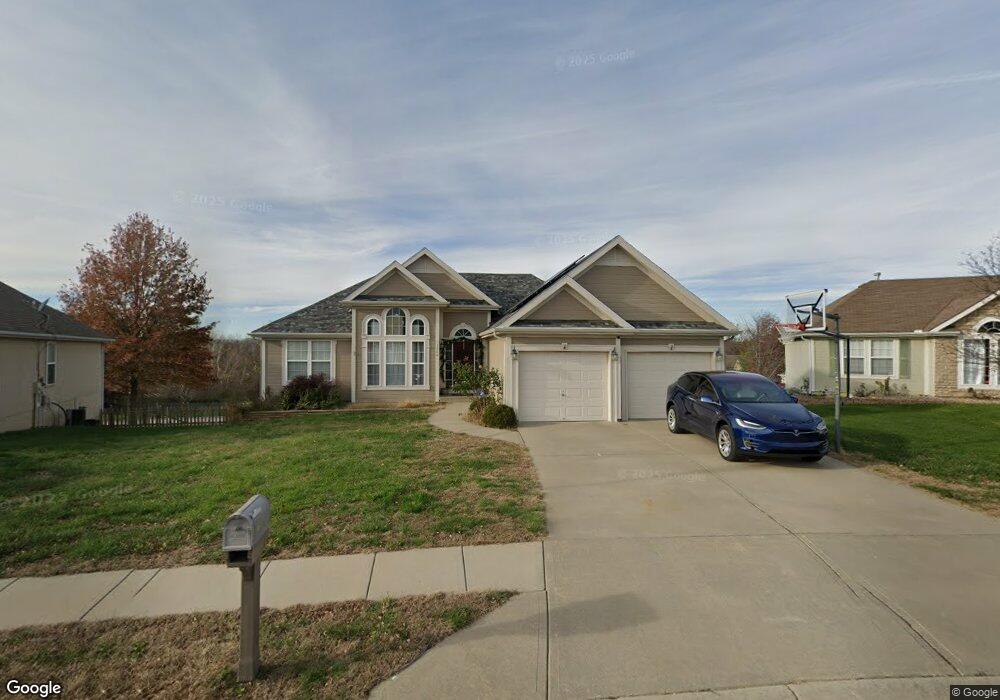
13880 Cole Trail Platte City, MO 64079
Estimated Value: $404,000 - $419,000
3
Beds
3
Baths
1,710
Sq Ft
$240/Sq Ft
Est. Value
About This Home
This home is located at 13880 Cole Trail, Platte City, MO 64079 and is currently estimated at $410,899, approximately $240 per square foot. 13880 Cole Trail is a home located in Platte County with nearby schools including Platte County High School.
Ownership History
Date
Name
Owned For
Owner Type
Purchase Details
Closed on
Feb 22, 2022
Sold by
Cowart and Randy
Bought by
Borselta Stormy and Hill Cedric
Current Estimated Value
Purchase Details
Closed on
Feb 9, 2009
Sold by
National Nominee Services Inc
Bought by
Cowart Jerome
Home Financials for this Owner
Home Financials are based on the most recent Mortgage that was taken out on this home.
Original Mortgage
$199,508
Interest Rate
5.06%
Mortgage Type
VA
Purchase Details
Closed on
Feb 4, 2009
Sold by
Brown Curtis Bruce and Brown Lynda Hammitt
Bought by
National Residential Nominee Services In
Home Financials for this Owner
Home Financials are based on the most recent Mortgage that was taken out on this home.
Original Mortgage
$199,508
Interest Rate
5.06%
Mortgage Type
VA
Purchase Details
Closed on
Jan 9, 2006
Sold by
D R Sherry Construction Ltd
Bought by
Brown Curtis B
Create a Home Valuation Report for This Property
The Home Valuation Report is an in-depth analysis detailing your home's value as well as a comparison with similar homes in the area
Home Values in the Area
Average Home Value in this Area
Purchase History
| Date | Buyer | Sale Price | Title Company |
|---|---|---|---|
| Borselta Stormy | -- | Coffelt Land Title | |
| Cowart Jerome | -- | -- | |
| National Residential Nominee Services In | -- | -- | |
| Brown Curtis B | -- | Platte County Title & Abstra |
Source: Public Records
Mortgage History
| Date | Status | Borrower | Loan Amount |
|---|---|---|---|
| Previous Owner | Cowart Jerome | $199,508 |
Source: Public Records
Tax History Compared to Growth
Tax History
| Year | Tax Paid | Tax Assessment Tax Assessment Total Assessment is a certain percentage of the fair market value that is determined by local assessors to be the total taxable value of land and additions on the property. | Land | Improvement |
|---|---|---|---|---|
| 2024 | $3,614 | $54,341 | $9,793 | $44,548 |
| 2023 | $3,614 | $54,341 | $9,793 | $44,548 |
| 2022 | $3,371 | $50,222 | $9,793 | $40,429 |
| 2021 | $3,380 | $50,222 | $9,793 | $40,429 |
| 2020 | $3,042 | $44,681 | $8,963 | $35,718 |
| 2019 | $3,042 | $44,681 | $8,963 | $35,718 |
| 2018 | $2,643 | $38,501 | $6,840 | $31,661 |
| 2017 | $2,629 | $38,501 | $6,840 | $31,661 |
| 2016 | $2,608 | $38,501 | $6,840 | $31,661 |
| 2015 | $2,607 | $38,501 | $6,840 | $31,661 |
| 2013 | $2,388 | $38,501 | $0 | $0 |
Source: Public Records
Map
Nearby Homes
- 13900 Cole Crossing Ct
- 13657 Oak Valley Dr
- 13420 Timber Park Dr
- 20 Norma Ln
- 17120 NW 133rd St
- 26 Hull Dr
- 609 Thomas Dr
- 1857 Wilkerson St
- 1863 Gates Ave
- 38 Hillcrest Dr
- 13180 Woodridge St
- 26 Misty Springs Cir
- 1505 Hale Ave
- 2111 Catie Ln
- 17340 NW 130th Terrace
- 13360 Ridgeview Dr
- 13060 Woodridge St
- 17575 N Alder Ct
- The York Plan at Seven Bridges
- The Wyndham V Plan at Seven Bridges
- 13880 Cole Trails N A
- 13870 Cole Trail
- 13890 Cole Trail
- 13900 Cole Trail
- 13860 Cole Trail
- 13875 Cole Trail
- 16710 NW 139th Ct
- 13865 Cole Trail
- 13850 Cole Trail
- 13915 Cole Crossing Ct
- 13895 Wagon Pass Rd
- 13880 Wagon Pass Rd
- 13920 Cole Crossing Ct
- 13855 Cole Trail
- 13920 Wagon Pass Ct
- 13860 Wagon Pass Rd
- 13840 Cole Trail
- 13925 Cole Crossing Ct
- 16705 NW 139th Ct
- 13885 Wagon Pass Rd