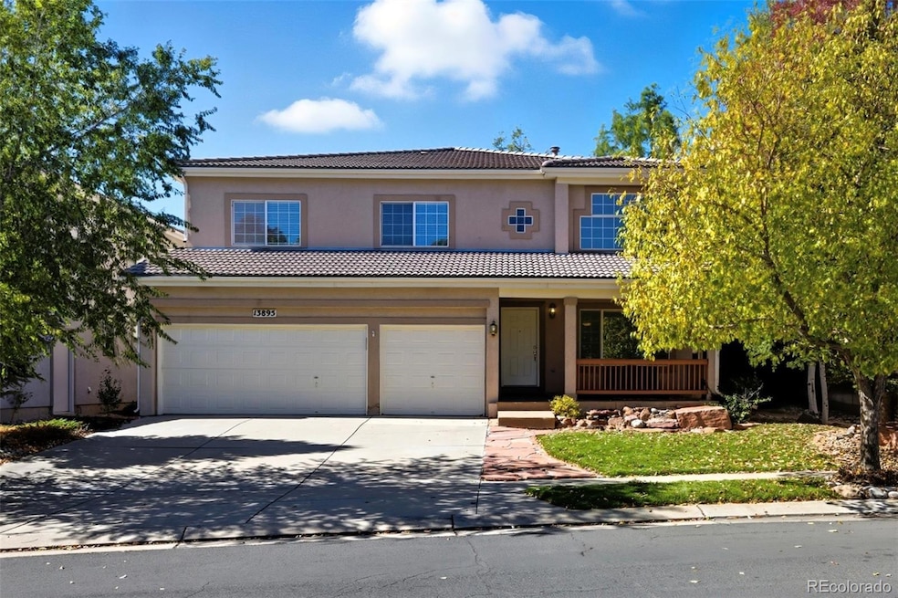
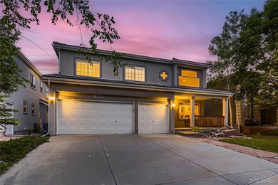
13895 Sandtrap Cir Broomfield, CO 80023
Broadlands NeighborhoodEstimated payment $4,802/month
Highlights
- On Golf Course
- Located in a master-planned community
- Deck
- Coyote Ridge Elementary School Rated A-
- Clubhouse
- Vaulted Ceiling
About This Home
Don't miss out on owning a home in the highly desirable Broadlands Community. Immaculately maintained and professionally managed Golf Course Community. Time and attention to detail spent around every corner to prepare this
home just for you! Move-In Ready!!! New paint throughout! New flooring! Remodeled kitchen! Stainless-steel
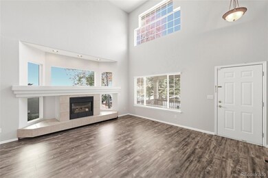
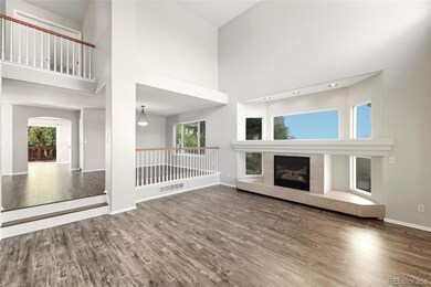
appliances! New countertops in kitchen and bathrooms! So many improvements! Grand entry with vaulted two-story
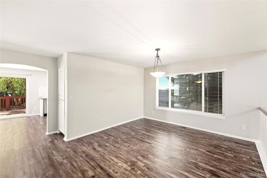
ceilings and tons of windows. Attractive Luxury Vinyl Plank flooring travels throughout the formal living & dining rooms.
Newly remodeled kitchen features all new stainless-steel appliances including double electric wall oven, glass cooktop
stove, over the range microwave, 3-door French door refrigerator, top control dishwasher and all new solid surface
countertops with gorgeous white luxury subway tile backsplash. Enjoy breakfast in your eat-in kitchen with large slider
that opens to the back deck. Family room features its own slider that opens to your new concrete patio off the deck. The
main level also features a private office, full bathroom and large laundry room with tons of cabinets for storage and
organizing. The upper level will not disappoint either with all new carpets and paint. Massive loft open to lower level offers
endless opportunities, large windows make this space bright and airy. Primary bedroom suite is privately situated on the
other side of the loft, offers spacious walk-in closet and large 5 piece en suite bathroom featuring new glass shower,
luxurious soaking tub, new countertops and new fixtures. 3 secondary bedrooms and hallway bathroom finish out the
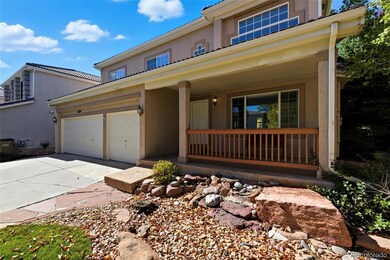
upper level. Freshly manicured backyard features large deck, mature trees for shade and privacy, and new firepit retreat
with seating. 3 car garage is extra deep w/ cabinets for storage. Unfinished basement offers even more space to grow!
Listing Agent
Stars and Stripes Homes Inc Brokerage Email: thuy@starsandstripeshomes.com,720-435-1777 License #100079205 Listed on: 06/13/2025
Home Details
Home Type
- Single Family
Est. Annual Taxes
- $6,248
Year Built
- Built in 1999
Lot Details
- 6,639 Sq Ft Lot
- On Golf Course
- East Facing Home
- Property is Fully Fenced
- Landscaped
- Front and Back Yard Sprinklers
- Property is zoned PUD
HOA Fees
Parking
- 3 Car Attached Garage
Home Design
- Spanish Architecture
- Spanish Tile Roof
- Stucco
Interior Spaces
- 2-Story Property
- Vaulted Ceiling
- Family Room
- Living Room
- Dining Room
- Home Office
- Loft
- Laundry Room
- Unfinished Basement
Bedrooms and Bathrooms
- 4 Bedrooms
- 3 Full Bathrooms
- Soaking Tub
Outdoor Features
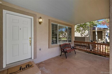
- Deck
- Covered Patio or Porch
- Fire Pit
Schools
- Coyote Ridge Elementary School
- Westlake Middle School
- Legacy High School
Utilities
- Forced Air Heating and Cooling System
Listing and Financial Details
- Exclusions: Staging items, broker set up items
- Assessor Parcel Number R0110995
Community Details
Overview
- Association fees include reserves, ground maintenance
- Broadlands Master Association, Phone Number (303) 429-2611
- Stone Creek Broadlands Association, Phone Number (303) 429-2611
- Broadlands Subdivision
- Located in a master-planned community
Amenities
- Clubhouse
Recreation
- Community Playground
- Community Pool
- Park
Map
Home Values in the Area
Average Home Value in this Area
Tax History
| Year | Tax Paid | Tax Assessment Tax Assessment Total Assessment is a certain percentage of the fair market value that is determined by local assessors to be the total taxable value of land and additions on the property. | Land | Improvement |
|---|---|---|---|---|
| 2025 | $6,248 | $54,650 | $12,730 | $41,920 |
| 2024 | $6,248 | $54,160 | $11,920 | $42,240 |
| 2023 | $6,197 | $60,010 | $13,210 | $46,800 |
| 2022 | $5,178 | $42,140 | $9,380 | $32,760 |
| 2021 | $5,338 | $43,350 | $9,650 | $33,700 |
| 2020 | $5,091 | $40,870 | $8,580 | $32,290 |
| 2019 | $5,093 | $41,160 | $8,640 | $32,520 |
| 2018 | $4,635 | $36,060 | $5,760 | $30,300 |
| 2017 | $4,256 | $39,870 | $6,370 | $33,500 |
| 2016 | $4,292 | $35,510 | $5,850 | $29,660 |
| 2015 | $4,291 | $29,460 | $5,850 | $23,610 |
| 2014 | $3,703 | $29,460 | $5,850 | $23,610 |
Property History
| Date | Event | Price | List to Sale | Price per Sq Ft |
|---|---|---|---|---|
| 11/07/2025 11/07/25 | Pending | -- | -- | -- |
| 10/31/2025 10/31/25 | Price Changed | $799,000 | -1.2% | $273 / Sq Ft |
| 10/11/2025 10/11/25 | For Sale | $809,000 | +1.1% | $277 / Sq Ft |
| 08/24/2025 08/24/25 | Off Market | $799,900 | -- | -- |
| 08/20/2025 08/20/25 | Price Changed | $799,900 | 0.0% | $274 / Sq Ft |
| 08/20/2025 08/20/25 | For Sale | $799,900 | -2.4% | $274 / Sq Ft |
| 08/18/2025 08/18/25 | Off Market | $819,900 | -- | -- |
| 08/01/2025 08/01/25 | Price Changed | $819,900 | -1.2% | $280 / Sq Ft |
| 07/07/2025 07/07/25 | Price Changed | $829,900 | -1.2% | $284 / Sq Ft |
| 06/20/2025 06/20/25 | Price Changed | $839,900 | -2.3% | $287 / Sq Ft |
| 06/13/2025 06/13/25 | For Sale | $859,900 | -- | $294 / Sq Ft |
Purchase History
| Date | Type | Sale Price | Title Company |
|---|---|---|---|
| Warranty Deed | $429,900 | Chicago Title Co | |
| Deed | $279,400 | -- | |
| Deed | $2,920,000 | -- | |
| Deed | $540,200 | -- |
Mortgage History
| Date | Status | Loan Amount | Loan Type |
|---|---|---|---|
| Open | $343,900 | Fannie Mae Freddie Mac |
Source: REcolorado®
MLS Number: 9941379
APN: 1573-19-4-06-022
Disclaimer: Certain information contained herein is derived from information provided by parties other than Homes.com. All information provided is deemed reliable, but is not guaranteed to be accurate and should be independently verified.
![]() The content relating to real estate for sale in this Web site comes in part from the Internet Data eXchange (“IDX”) program of METROLIST, INC., DBA RECOLORADO®. Real estate listings held by brokers other than Ten-X are marked with the IDX Logo. This information is being provided for the consumers’ personal, non-commercial use and may not be used for any other purpose. All information subject to change and should be independently verified.
The content relating to real estate for sale in this Web site comes in part from the Internet Data eXchange (“IDX”) program of METROLIST, INC., DBA RECOLORADO®. Real estate listings held by brokers other than Ten-X are marked with the IDX Logo. This information is being provided for the consumers’ personal, non-commercial use and may not be used for any other purpose. All information subject to change and should be independently verified.
This publication is designed to provide information with regard to the subject matter covered. It is displayed with the understanding that the publisher and authors are not engaged in rendering real estate, legal, accounting, tax, or other professional services and that the publisher and authors are not offering such advice in this publication. If real estate, legal, or other expert assistance is required, the services of a competent, professional person should be sought.
The information contained in this publication is subject to change without notice. METROLIST, INC., DBA RECOLORADO MAKES NO WARRANTY OF ANY KIND WITH REGARD TO THIS MATERIAL, INCLUDING, BUT NOT LIMITED TO, THE IMPLIED WARRANTIES OF MERCHANTABILITY AND FITNESS FOR A PARTICULAR PURPOSE. METROLIST, INC., DBA RECOLORADO SHALL NOT BE LIABLE FOR ERRORS CONTAINED HEREIN OR FOR ANY DAMAGES IN CONNECTION WITH THE FURNISHING, PERFORMANCE, OR USE OF THIS MATERIAL.
PUBLISHER’S NOTICE: All real estate advertised herein is subject to the Federal Fair Housing Act and the Colorado Fair Housing Act, which Acts make it illegal to make or publish any advertisement that indicates any preference, limitation, or discrimination based on race, color, religion, sex, handicap, familial status, or national origin.
METROLIST, INC., DBA RECOLORADO will not knowingly accept any advertising for real estate that is in violation of the law. All persons are hereby informed that all dwellings advertised are available on an equal opportunity basis.
© 2025 METROLIST, INC., DBA RECOLORADO® – All Rights Reserved. 6455 S. Yosemite St., Suite 500 Greenwood Village, CO 80111 USA
ALL RIGHTS RESERVED WORLDWIDE. No part of this publication may be reproduced, adapted, translated, stored in a retrieval system or transmitted in any form or by any means, electronic, mechanical, photocopying, recording, or otherwise, without the prior written permission of the publisher. The information contained herein including but not limited to all text, photographs, digital images, virtual tours, may be seeded and monitored for protection and tracking.
- 13859 Legend Trail Unit 103
- 13872 Legend Way Unit 101
- 13755 Troon Ct
- 3860 Broadlands Ln
- 13689 Boulder Point Unit 102
- 14189 Sun Blaze Loop Unit F
- 3751 W 136th Ave Unit C4
- 3751 W 136th Ave Unit C3
- 3751 W 136th Ave
- 3751 W 136th Ave Unit E4
- 13676 Rock Point Unit 101
- 3420 Boulder Cir Unit 201
- 3220 Boulder Cir Unit 103
- 13648 Plaster Point Unit 102
- 3545 Molly Cir Unit 3545
- 4405 Fairway Ln
- 3574 Buffalo Ave
- 13380 Red Deer Trail
- 4540 Elizabeth Ln
- 4725 Spyglass Dr
