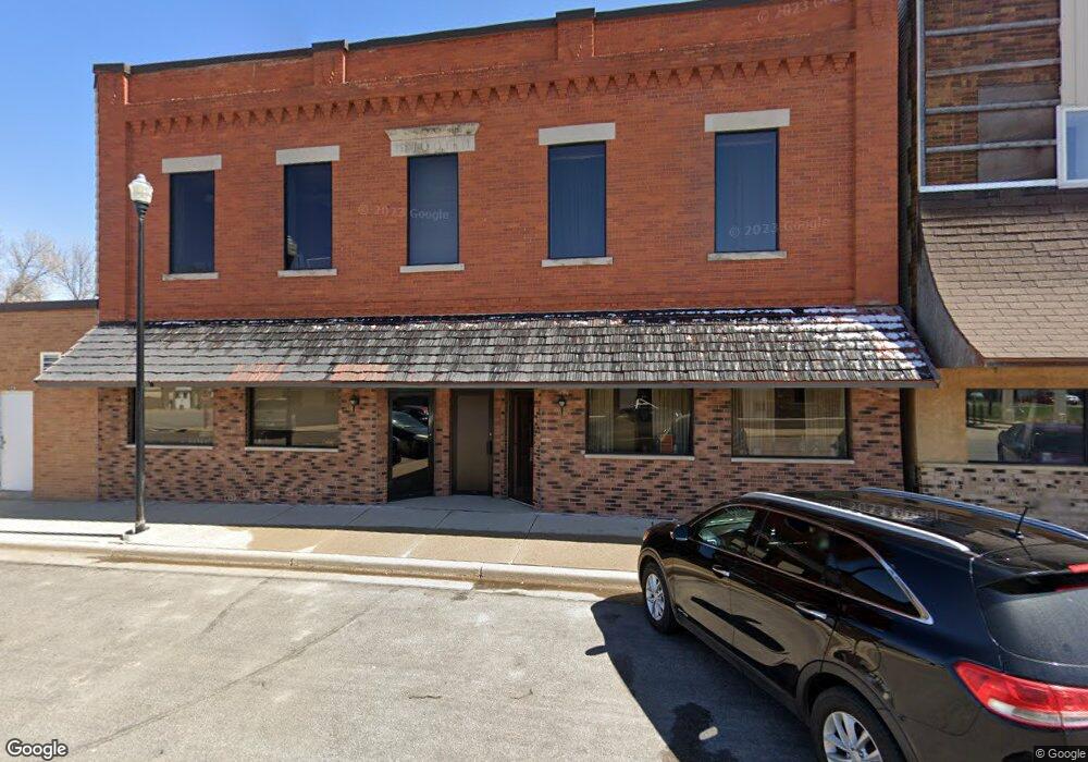
139 4th Ave N Brownton, MN 55312
Estimated Value: $58,133
--
Bed
--
Bath
3,138
Sq Ft
$19/Sq Ft
Est. Value
About This Home
This home is located at 139 4th Ave N, Brownton, MN 55312 and is currently estimated at $58,133, approximately $18 per square foot. 139 4th Ave N is a home located in McLeod County with nearby schools including Lincoln Elementary School, Lakeside Elementary School, and Glencoe-Silver Lake Jr. High School.
Ownership History
Date
Name
Owned For
Owner Type
Purchase Details
Closed on
Apr 30, 2014
Bought by
Buxcel Larry L and Buxcel Karen M
Current Estimated Value
Home Financials for this Owner
Home Financials are based on the most recent Mortgage that was taken out on this home.
Original Mortgage
$28,150
Outstanding Balance
$21,454
Interest Rate
4.33%
Estimated Equity
$36,679
Create a Home Valuation Report for This Property
The Home Valuation Report is an in-depth analysis detailing your home's value as well as a comparison with similar homes in the area
Home Values in the Area
Average Home Value in this Area
Purchase History
| Date | Buyer | Sale Price | Title Company |
|---|---|---|---|
| Buxcel Larry L | -- | Mcleod County Abstract & Tit | |
| Karen Larry L | $29,200 | -- |
Source: Public Records
Mortgage History
| Date | Status | Borrower | Loan Amount |
|---|---|---|---|
| Open | Karen Larry L | $28,150 | |
| Closed | Buxcel Larry L | $20,400 |
Source: Public Records
Tax History Compared to Growth
Tax History
| Year | Tax Paid | Tax Assessment Tax Assessment Total Assessment is a certain percentage of the fair market value that is determined by local assessors to be the total taxable value of land and additions on the property. | Land | Improvement |
|---|---|---|---|---|
| 2024 | $1,654 | $49,100 | $10,700 | $38,400 |
| 2023 | $1,488 | $49,100 | $10,700 | $38,400 |
| 2022 | $1,682 | $49,100 | $10,700 | $38,400 |
| 2021 | $1,694 | $44,100 | $9,200 | $34,900 |
| 2020 | $1,548 | $43,600 | $9,200 | $34,400 |
| 2019 | $1,502 | $35,000 | $9,200 | $25,800 |
| 2018 | $1,442 | $0 | $0 | $0 |
| 2017 | $1,996 | $0 | $0 | $0 |
| 2016 | $2,162 | $0 | $0 | $0 |
| 2015 | $1,992 | $0 | $0 | $0 |
| 2014 | -- | $0 | $0 | $0 |
Source: Public Records
Map
Nearby Homes
- 531 2nd St N
- 221 3rd Ave S
- 122 2nd Ave S
- xxx Lot 3 Division St W
- 752 2nd St N
- 304 1st Ave N
- 237 5th St N
- 7612 Plum Ave
- Lot 2 U S Highway 212
- XXX US Hwy 212
- xxx Lot 2 Us Hwy 212
- 16452 90th St
- 11655 Sunset Cir
- 11742 Sunset Cir
- 7900 Lace Ave
- 7900 Lace Ave N
- 13198 100th St
- 12893 County Road 7
- Lot 2 Tagus Ave
- 15554 130th St
- 129 4th Ave N
- 417 2nd Ave N
- 421 421 2nd-Avenue-n
- 111 4th Ave N
- 107 4th Ave N
- 424 2nd St N Unit 8
- 219 4th Ave N
- 220 5th Ave N
- 121 3rd Ave N
- 130 5th Ave S
- 108 4th Ave S
- 116 4th Ave S
- 0 2nd St N Unit 4969786
- 138 5th Ave S
- 135 135 5th-Avenue-s
- 108 2nd Ave N
- 113 3rd St S
- 524 Division St
- 113 3rd Ave S
- 131 5th Ave S