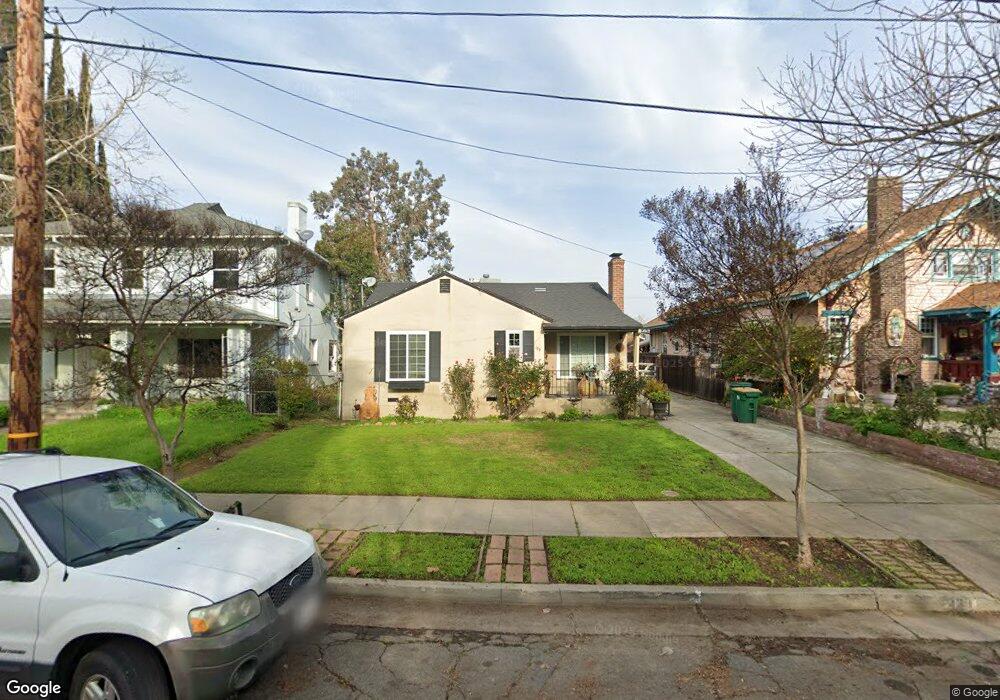
139 E Maple St Stockton, CA 95204
Midtown NeighborhoodEstimated Value: $331,113 - $374,000
2
Beds
1
Bath
1,089
Sq Ft
$326/Sq Ft
Est. Value
About This Home
This home is located at 139 E Maple St, Stockton, CA 95204 and is currently estimated at $354,778, approximately $325 per square foot. 139 E Maple St is a home located in San Joaquin County with nearby schools including Wilson Elementary School, El Dorado Elementary School, and Cleveland Elementary School.
Ownership History
Date
Name
Owned For
Owner Type
Purchase Details
Closed on
May 3, 1999
Sold by
Jenson Lorraine C
Bought by
Ramirez Steven A and Ramirez Mayra G
Current Estimated Value
Home Financials for this Owner
Home Financials are based on the most recent Mortgage that was taken out on this home.
Original Mortgage
$84,609
Outstanding Balance
$21,717
Interest Rate
6.96%
Mortgage Type
VA
Estimated Equity
$333,061
Purchase Details
Closed on
Jul 13, 1998
Sold by
Ann Jenson Cheryl and Lewis Robert
Bought by
Jenson Lorraine C
Create a Home Valuation Report for This Property
The Home Valuation Report is an in-depth analysis detailing your home's value as well as a comparison with similar homes in the area
Home Values in the Area
Average Home Value in this Area
Purchase History
| Date | Buyer | Sale Price | Title Company |
|---|---|---|---|
| Ramirez Steven A | $83,000 | First American Title Co | |
| Jenson Lorraine C | -- | -- |
Source: Public Records
Mortgage History
| Date | Status | Borrower | Loan Amount |
|---|---|---|---|
| Open | Ramirez Steven A | $84,609 |
Source: Public Records
Tax History
| Year | Tax Paid | Tax Assessment Tax Assessment Total Assessment is a certain percentage of the fair market value that is determined by local assessors to be the total taxable value of land and additions on the property. | Land | Improvement |
|---|---|---|---|---|
| 2025 | $1,674 | $130,030 | $62,703 | $67,327 |
| 2024 | $1,647 | $127,481 | $61,474 | $66,007 |
| 2023 | $1,610 | $124,982 | $60,269 | $64,713 |
| 2022 | $1,549 | $122,533 | $59,088 | $63,445 |
| 2021 | $1,489 | $120,131 | $57,930 | $62,201 |
| 2020 | $1,517 | $118,900 | $57,336 | $61,564 |
| 2019 | $1,511 | $116,569 | $56,212 | $60,357 |
| 2018 | $1,483 | $114,284 | $55,110 | $59,174 |
| 2017 | $1,406 | $112,044 | $54,030 | $58,014 |
| 2016 | $1,431 | $109,847 | $52,970 | $56,877 |
| 2014 | $1,362 | $106,078 | $51,153 | $54,925 |
Source: Public Records
Map
Nearby Homes
- 1900 N El Dorado St
- 1905 N El Dorado St
- 1941 N El Dorado St
- 1637 N Hunter St
- 1617 N El Dorado St
- 402 E Wyandotte St
- 405 E Cleveland St
- 207 E Adams St
- 1418 N Center St
- 2212 N Sutter St
- 52 W Adams St
- 1401 N San Joaquin St
- 11 E Geary St
- 328 W Walnut St
- 61 E Ellis St
- 116 E Noble St
- 228 W Willow St
- 64 E Noble St
- 312 E Noble St
- 236 W Willow St
- 133 E Maple St
- 143 E Maple St
- 125 E Maple St
- 145 E Maple St
- 147 E Maple St
- 138 E Wyandotte St
- 123 E Maple St
- 136 E Wyandotte St
- 140 E Wyandotte St
- 1835 N Hunter St
- 1829 N Hunter St
- 128 E Wyandotte St
- 1821 N Hunter St
- 1843 N Hunter St
- 146 E Wyandotte St
- 1930 N El Dorado St
- 120 E Wyandotte St
- 1815 N Hunter St
- 142 E Maple St
- 138 E Maple St
Your Personal Tour Guide
Ask me questions while you tour the home.