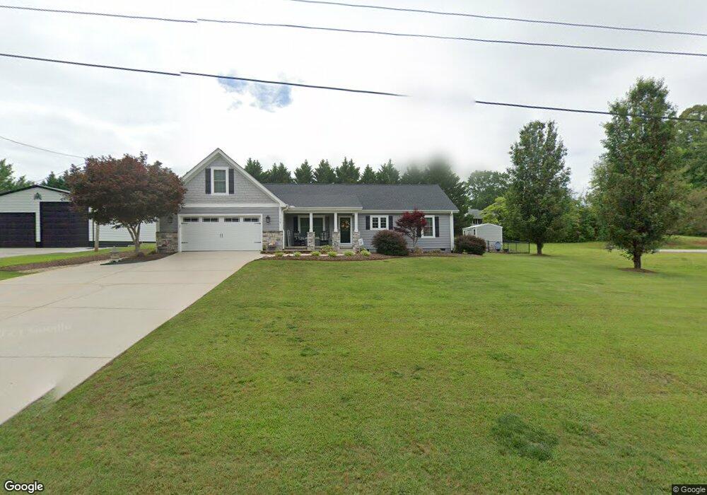
139 Randall Ct West Union, SC 29696
Estimated Value: $309,000 - $364,000
3
Beds
2
Baths
1,531
Sq Ft
$218/Sq Ft
Est. Value
About This Home
This home is located at 139 Randall Ct, West Union, SC 29696 and is currently estimated at $334,402, approximately $218 per square foot. 139 Randall Ct is a home located in Oconee County with nearby schools including Walhalla Elementary School, Walhalla Middle School, and Walhalla High School.
Ownership History
Date
Name
Owned For
Owner Type
Purchase Details
Closed on
Aug 12, 2023
Sold by
Glenn Rita M
Bought by
Crenshaw Gracie L
Current Estimated Value
Purchase Details
Closed on
Apr 18, 2021
Sold by
Vinson Misty C and Vinson Kenneth L
Bought by
Glenn Rita M
Purchase Details
Closed on
Dec 14, 2009
Sold by
Crenshaw Misty C and Vinson Misty C
Bought by
Vinson Misty C and Vinson Kenneth L
Purchase Details
Closed on
Sep 7, 2007
Sold by
Randy Moore Builders Inc
Bought by
Crenshaw Misty C
Purchase Details
Closed on
Mar 29, 2007
Sold by
Lewis Arthur J
Bought by
Randy Moore Builders Inc
Create a Home Valuation Report for This Property
The Home Valuation Report is an in-depth analysis detailing your home's value as well as a comparison with similar homes in the area
Home Values in the Area
Average Home Value in this Area
Purchase History
| Date | Buyer | Sale Price | Title Company |
|---|---|---|---|
| Crenshaw Gracie L | -- | None Listed On Document | |
| Glenn Rita M | $265,000 | None Available | |
| Vinson Misty C | -- | -- | |
| Crenshaw Misty C | $180,000 | Attorney | |
| Randy Moore Builders Inc | $20,000 | None Available |
Source: Public Records
Tax History Compared to Growth
Tax History
| Year | Tax Paid | Tax Assessment Tax Assessment Total Assessment is a certain percentage of the fair market value that is determined by local assessors to be the total taxable value of land and additions on the property. | Land | Improvement |
|---|---|---|---|---|
| 2025 | $784 | $7,471 | $495 | $6,976 |
| 2024 | $784 | $7,471 | $495 | $6,976 |
| 2023 | $581 | $7,471 | $495 | $6,976 |
| 2022 | $581 | $7,471 | $495 | $6,976 |
| 2021 | $1,634 | $7,182 | $495 | $6,687 |
| 2020 | $1,634 | $0 | $0 | $0 |
| 2019 | $799 | $0 | $0 | $0 |
| 2018 | $1,440 | $0 | $0 | $0 |
| 2017 | $677 | $0 | $0 | $0 |
| 2016 | $677 | $0 | $0 | $0 |
| 2015 | -- | $0 | $0 | $0 |
| 2014 | -- | $9,671 | $675 | $8,996 |
| 2013 | -- | $0 | $0 | $0 |
Source: Public Records
Map
Nearby Homes
- 517 Fowler Rd
- 130 Raleighs Ln
- Lot 7 Winstead Rd
- 621 Burns Mill Rd
- 00 Eleanore Dr
- 625 Burns Mill Rd
- Lot 44 Glassy Water Way
- 106 Torrington Rd
- 204 Friendship Dr
- 130 Quail Haven Dr
- 115 Burns Mill Rd
- 209 Moore Ave
- 203 Tulip Dr
- 00 Fox Run Rd
- Lot 57 Fox Run Rd
- 221 Cub Cove Dr
- 146 Jefferson Rd
- 173 W Waters Edge Ln
- 141 W Waters Edge Ln
- 137 W Waters Edge Ln
- 139 Randall Ct Unit COUNTRY VILLA S/D
- 111 Sunset Dr
- 135 Randall Ct Unit COUNTRY VILLA S/D
- 135 Randall Ct
- 113 Sunset Dr
- 106 Randall Ct
- 134 Randall Ct
- 115 Sunset Dr
- 109 Sunset Dr
- 105 Sunset Dr
- 107 Randall Ct
- 105 Randall Ct
- 109 Randall Ct
- 523 Fowler Rd
- 130 Randall Ct
- 108 Sunset Dr
- 112 Randall Ct
- 112 Randall Ct
- 106 Sunset Dr
- 00 Sunset Dr