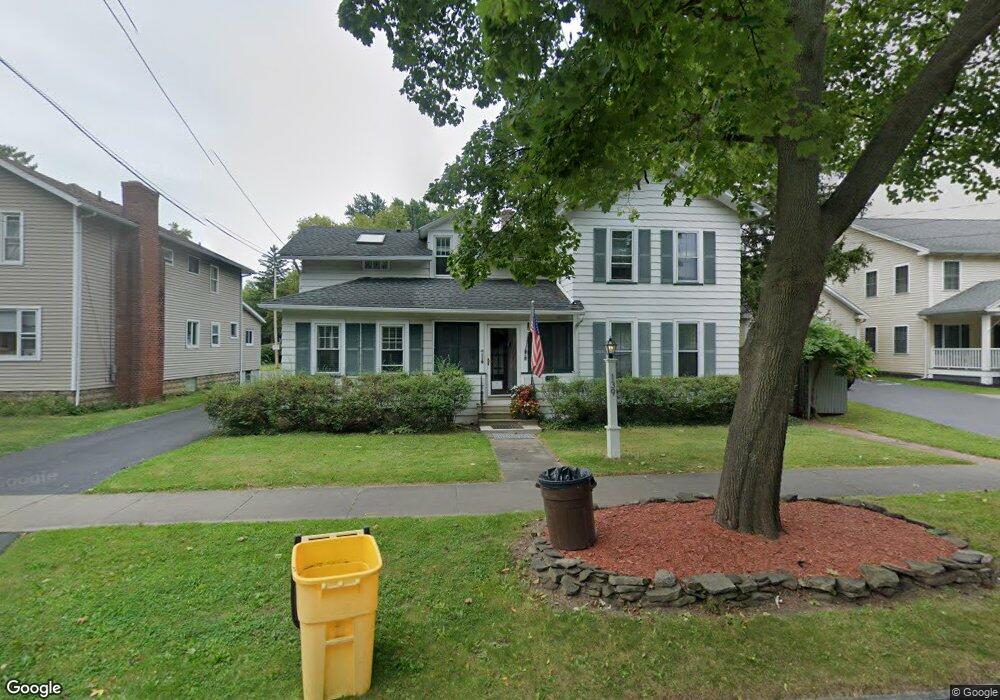
139 S Main St Fairport, NY 14450
Estimated Value: $388,000 - $418,000
4
Beds
3
Baths
2,340
Sq Ft
$173/Sq Ft
Est. Value
About This Home
This home is located at 139 S Main St, Fairport, NY 14450 and is currently estimated at $403,732, approximately $172 per square foot. 139 S Main St is a home located in Monroe County with nearby schools including Brooks Hill School, Johanna Perrin Middle School, and Minerva Deland School.
Ownership History
Date
Name
Owned For
Owner Type
Purchase Details
Closed on
Oct 7, 2024
Sold by
Mcmahon Lorraine
Bought by
Oswald Collin C and Oswald Sydney G
Current Estimated Value
Purchase Details
Closed on
Dec 27, 2005
Sold by
Mcmahon John
Bought by
Mcmahon Lorraine
Purchase Details
Closed on
Mar 29, 1996
Sold by
Corss James
Bought by
Mcmahon John M and Mc Mahon Lorraine
Purchase Details
Closed on
Aug 4, 1995
Sold by
Cross Mary E and Cross James
Bought by
Cross Mary E and Cross James
Create a Home Valuation Report for This Property
The Home Valuation Report is an in-depth analysis detailing your home's value as well as a comparison with similar homes in the area
Home Values in the Area
Average Home Value in this Area
Purchase History
| Date | Buyer | Sale Price | Title Company |
|---|---|---|---|
| Oswald Collin C | $370,000 | None Listed On Document | |
| Oswald Collin C | $370,000 | None Listed On Document | |
| Mcmahon Lorraine | -- | Michael Kieffer | |
| Mcmahon John M | $106,000 | -- | |
| Cross Mary E | -- | -- |
Source: Public Records
Tax History Compared to Growth
Tax History
| Year | Tax Paid | Tax Assessment Tax Assessment Total Assessment is a certain percentage of the fair market value that is determined by local assessors to be the total taxable value of land and additions on the property. | Land | Improvement |
|---|---|---|---|---|
| 2024 | $8,238 | $169,800 | $47,000 | $122,800 |
| 2023 | $7,865 | $169,800 | $47,000 | $122,800 |
| 2022 | $7,649 | $169,800 | $47,000 | $122,800 |
| 2021 | $7,652 | $169,800 | $47,000 | $122,800 |
| 2020 | $7,693 | $169,800 | $47,000 | $122,800 |
| 2019 | $5,670 | $169,800 | $32,900 | $136,900 |
| 2018 | $7,341 | $169,800 | $32,900 | $136,900 |
| 2017 | $3,745 | $157,200 | $32,900 | $124,300 |
| 2016 | $5,670 | $157,200 | $32,900 | $124,300 |
| 2015 | -- | $157,200 | $32,900 | $124,300 |
| 2014 | -- | $157,200 | $32,900 | $124,300 |
Source: Public Records
Map
Nearby Homes
- 31 Dewey Ave
- 105 Packetts Glen
- 3 Packetts Glen
- 76 - 78 Summit St
- 15 Great Wood Ct Unit 6
- 70 High St
- 27-8 Great Wood Ct Unit 8
- 112 Roselawn Ave
- 158 N Main St
- 12 Deland Park A
- 73 Clarkes Crossing
- 19 Homestead Dr
- 14 Peppermill Dr
- 24 Lisand Dr
- 86 Broxbourne Dr
- 10 Lonesome Rd
- 15 Whitney Farms Cir
- 282 Moseley Rd
- 603 Watson Rd
- 43 Hollingham Rise
- 143 S Main St
- 134 S Main St
- 142 S Main St
- 9 Orchard St
- 131 S Main St
- 131 S Main St Unit Lower
- 11 Orchard St
- 4 Jackson Place
- 152 S Main St
- 15 Orchard St
- 127 S Main St
- 1 Jackson Place
- 155 S Main St
- 10 Orchard St
- 6 Jackson Place
- 10 Clinton Place
- 130 S Main St
- 156 S Main St
- 5 Clinton Place
- 125 S Main St