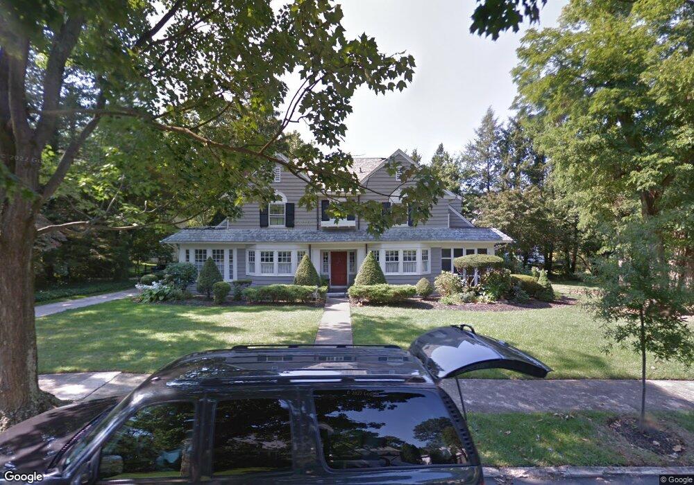
139 Treaty Elm Ln Haddonfield, NJ 08033
Estimated Value: $1,198,274 - $1,552,000
--
Bed
--
Bath
2,894
Sq Ft
$481/Sq Ft
Est. Value
About This Home
This home is located at 139 Treaty Elm Ln, Haddonfield, NJ 08033 and is currently estimated at $1,391,069, approximately $480 per square foot. 139 Treaty Elm Ln is a home located in Camden County with nearby schools including Haddonfield Memorial High School, Haddonfield Friends School, and Christ the King Regional School.
Ownership History
Date
Name
Owned For
Owner Type
Purchase Details
Closed on
Sep 11, 2025
Sold by
Walker James and Walker Michele
Bought by
Kelly Builders Inc
Current Estimated Value
Home Financials for this Owner
Home Financials are based on the most recent Mortgage that was taken out on this home.
Original Mortgage
$1,950,000
Outstanding Balance
$1,950,000
Interest Rate
6.72%
Mortgage Type
New Conventional
Estimated Equity
-$558,931
Purchase Details
Closed on
Jun 18, 1993
Bought by
Walker James and Walker Michele
Create a Home Valuation Report for This Property
The Home Valuation Report is an in-depth analysis detailing your home's value as well as a comparison with similar homes in the area
Home Values in the Area
Average Home Value in this Area
Purchase History
| Date | Buyer | Sale Price | Title Company |
|---|---|---|---|
| Kelly Builders Inc | $1,450,000 | Surety Title | |
| Walker James | -- | -- |
Source: Public Records
Mortgage History
| Date | Status | Borrower | Loan Amount |
|---|---|---|---|
| Open | Kelly Builders Inc | $1,950,000 |
Source: Public Records
Tax History Compared to Growth
Tax History
| Year | Tax Paid | Tax Assessment Tax Assessment Total Assessment is a certain percentage of the fair market value that is determined by local assessors to be the total taxable value of land and additions on the property. | Land | Improvement |
|---|---|---|---|---|
| 2025 | $22,485 | $695,900 | $548,200 | $147,700 |
| 2024 | $22,185 | $695,900 | $548,200 | $147,700 |
| 2023 | $22,185 | $695,900 | $548,200 | $147,700 |
| 2022 | $22,011 | $695,900 | $548,200 | $147,700 |
| 2021 | $21,900 | $695,900 | $548,200 | $147,700 |
| 2020 | $21,747 | $695,900 | $548,200 | $147,700 |
| 2019 | $216 | $695,900 | $548,200 | $147,700 |
| 2018 | $21,315 | $695,900 | $548,200 | $147,700 |
| 2017 | $20,807 | $695,900 | $548,200 | $147,700 |
| 2016 | $20,341 | $695,900 | $548,200 | $147,700 |
| 2015 | $19,777 | $695,900 | $548,200 | $147,700 |
| 2014 | $19,339 | $695,900 | $548,200 | $147,700 |
Source: Public Records
Map
Nearby Homes
- 315 Hutchinson Ave
- 351 Bellevue Ave
- 425 Peltoma Rd
- 320 Warwick Rd
- 125 W Summit Ave
- 301 Bradshaw Ave
- 95 Lane of Acres
- 1201 Wayne Rd
- 341 Station Ave
- 518 Carver Ct
- 134 Kent Rd
- 428 Mansfield Ave
- 130 Centre St
- 120 Kings Hwy W
- 303 Highland Ave
- 412 E Summit Ave
- 107 Centre St
- 2 Loucroft Ave
- 290 Tavistock
- 316 N Woodstock Dr