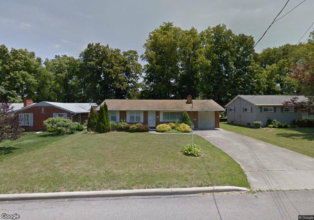
139 Westgate Dr Mansfield, OH 44906
Estimated Value: $151,299 - $183,000
2
Beds
2
Baths
1,232
Sq Ft
$137/Sq Ft
Est. Value
About This Home
This home is located at 139 Westgate Dr, Mansfield, OH 44906 and is currently estimated at $168,575, approximately $136 per square foot. 139 Westgate Dr is a home located in Richland County with nearby schools including Mansfield Elective Academy, Interactive Media & Construction (IMAC) Academy, and Buckeye Community School.
Ownership History
Date
Name
Owned For
Owner Type
Purchase Details
Closed on
Jun 1, 2015
Sold by
Burnell Elvin and Burnell Linda
Bought by
Hunt John R
Current Estimated Value
Home Financials for this Owner
Home Financials are based on the most recent Mortgage that was taken out on this home.
Original Mortgage
$72,659
Outstanding Balance
$56,276
Interest Rate
3.75%
Mortgage Type
FHA
Estimated Equity
$112,299
Purchase Details
Closed on
Sep 10, 1996
Sold by
Strong Mark A
Bought by
Ilo S Burnell
Purchase Details
Closed on
Jun 1, 1995
Sold by
Hoff Martha J
Bought by
Mark A Strong
Home Financials for this Owner
Home Financials are based on the most recent Mortgage that was taken out on this home.
Original Mortgage
$76,000
Interest Rate
8.26%
Mortgage Type
New Conventional
Create a Home Valuation Report for This Property
The Home Valuation Report is an in-depth analysis detailing your home's value as well as a comparison with similar homes in the area
Home Values in the Area
Average Home Value in this Area
Purchase History
| Date | Buyer | Sale Price | Title Company |
|---|---|---|---|
| Hunt John R | $74,000 | Attorney | |
| Ilo S Burnell | $93,000 | -- | |
| Mark A Strong | $82,100 | -- |
Source: Public Records
Mortgage History
| Date | Status | Borrower | Loan Amount |
|---|---|---|---|
| Open | Hunt John R | $72,659 | |
| Previous Owner | Mark A Strong | $76,000 |
Source: Public Records
Tax History Compared to Growth
Tax History
| Year | Tax Paid | Tax Assessment Tax Assessment Total Assessment is a certain percentage of the fair market value that is determined by local assessors to be the total taxable value of land and additions on the property. | Land | Improvement |
|---|---|---|---|---|
| 2024 | $1,562 | $33,350 | $4,500 | $28,850 |
| 2023 | $1,562 | $33,350 | $4,500 | $28,850 |
| 2022 | $1,371 | $24,530 | $3,860 | $20,670 |
| 2021 | $1,380 | $24,530 | $3,860 | $20,670 |
| 2020 | $1,411 | $24,530 | $3,860 | $20,670 |
| 2019 | $1,564 | $24,530 | $3,860 | $20,670 |
| 2018 | $1,543 | $24,530 | $3,860 | $20,670 |
| 2017 | $1,466 | $24,530 | $3,860 | $20,670 |
| 2016 | $1,431 | $22,670 | $4,080 | $18,590 |
| 2015 | $1,367 | $22,670 | $4,080 | $18,590 |
| 2014 | $847 | $22,670 | $4,080 | $18,590 |
| 2012 | $324 | $23,860 | $4,290 | $19,570 |
Source: Public Records
Map
Nearby Homes
- 142 Grasmere Ave
- 216 S Trimble Rd Unit 218
- 143 Kingwood Place
- 232 S Trimble Rd Unit 234
- 244 S Trimble Rd Unit 246
- 190 S Linden Rd
- 1068 Linwood Place
- 37 S Linden Rd
- 212 Marlow Rd
- 143 Fairlawn Ave
- 129 Fairlawn Ave
- 135 Fairlawn Ave
- 191 Fairlawn Ave
- 143 Buckeye Ave
- 147 Wimbledon Dr
- 408 Fairlawn Ave
- 118 Parkwood Blvd
- 679 Coleman Rd
- 0 W Fourth St - Trimble Lenox
- 1157 Deer Run Rd
- 131 Westgate Dr
- 151 Westgate Dr
- 125 Westgate Dr
- 155 Westgate Dr
- 140 S Trimble Rd
- 146 S Trimble Rd
- 117 Westgate Dr
- 140 Westgate Dr
- 148 Westgate Dr
- 159 Westgate Dr
- 150 S Trimble Rd
- 130 Westgate Dr
- 154 Westgate Dr
- 156 S Trimble Rd
- 124 Westgate Dr
- 109 Westgate Dr
- 160 Westgate Dr
- 160 S Trimble Rd
- 112 S Trimble Rd
- 116 Westgate Dr