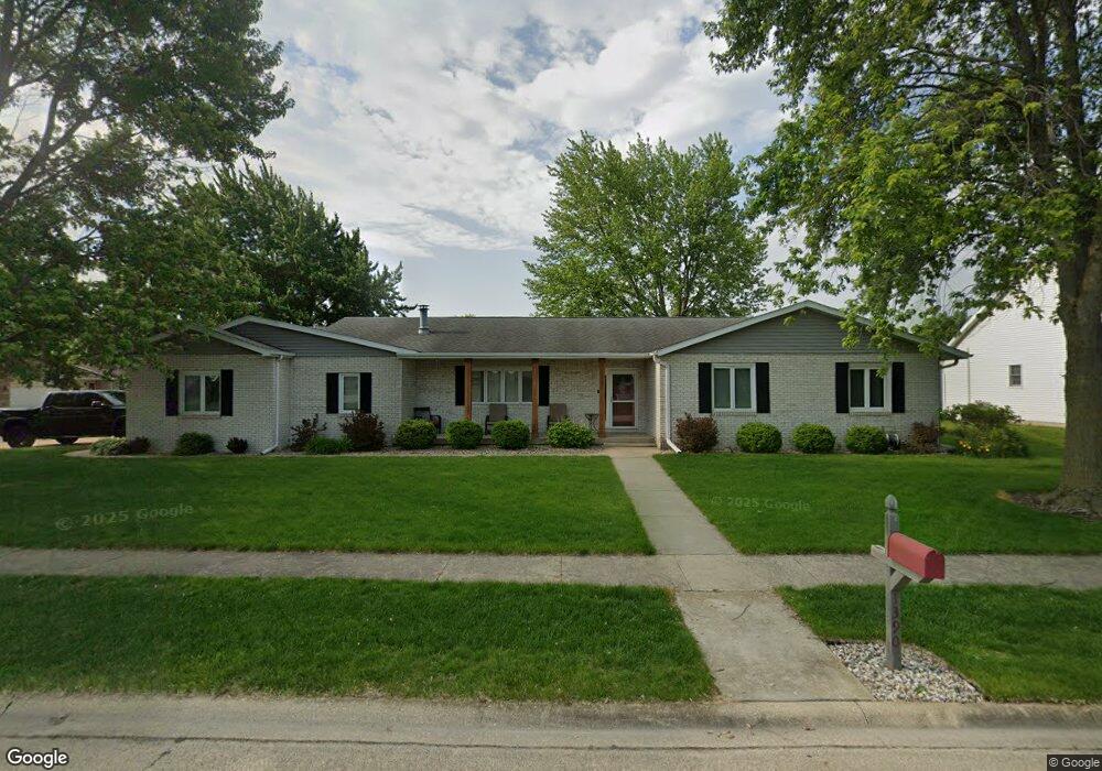
1390 Mac Arthur Dr Bradley, IL 60915
Estimated Value: $278,000 - $296,891
3
Beds
3
Baths
1,818
Sq Ft
$160/Sq Ft
Est. Value
About This Home
This home is located at 1390 Mac Arthur Dr, Bradley, IL 60915 and is currently estimated at $289,973, approximately $159 per square foot. 1390 Mac Arthur Dr is a home located in Kankakee County with nearby schools including Bradley East Elementary School, Bradley West Elementary School, and Bradley Central Middle School.
Ownership History
Date
Name
Owned For
Owner Type
Purchase Details
Closed on
Aug 16, 2016
Sold by
Futrell Sally S Trust
Bought by
Perry Petreikis
Current Estimated Value
Home Financials for this Owner
Home Financials are based on the most recent Mortgage that was taken out on this home.
Original Mortgage
$123,200
Outstanding Balance
$54,994
Interest Rate
2.87%
Mortgage Type
New Conventional
Estimated Equity
$234,979
Create a Home Valuation Report for This Property
The Home Valuation Report is an in-depth analysis detailing your home's value as well as a comparison with similar homes in the area
Home Values in the Area
Average Home Value in this Area
Purchase History
| Date | Buyer | Sale Price | Title Company |
|---|---|---|---|
| Perry Petreikis | $154,000 | Standard Title |
Source: Public Records
Mortgage History
| Date | Status | Borrower | Loan Amount |
|---|---|---|---|
| Open | Perry Petreikis | $123,200 |
Source: Public Records
Tax History Compared to Growth
Tax History
| Year | Tax Paid | Tax Assessment Tax Assessment Total Assessment is a certain percentage of the fair market value that is determined by local assessors to be the total taxable value of land and additions on the property. | Land | Improvement |
|---|---|---|---|---|
| 2024 | $6,371 | $78,899 | $7,263 | $71,636 |
| 2023 | $5,910 | $71,123 | $6,725 | $64,398 |
| 2022 | $5,750 | $66,744 | $6,482 | $60,262 |
| 2021 | $5,769 | $66,418 | $7,482 | $58,936 |
| 2020 | $5,340 | $62,970 | $7,282 | $55,688 |
| 2019 | $5,171 | $58,561 | $7,070 | $51,491 |
| 2018 | $4,818 | $55,067 | $5,332 | $49,735 |
| 2017 | $4,607 | $51,796 | $5,202 | $46,594 |
| 2016 | $3,915 | $50,130 | $5,125 | $45,005 |
| 2015 | $3,793 | $48,759 | $5,074 | $43,685 |
| 2014 | $3,742 | $49,261 | $5,074 | $44,187 |
| 2013 | -- | $54,064 | $5,074 | $48,990 |
Source: Public Records
Map
Nearby Homes
- 1248 Madison Ct
- 641 N Jackson Ave
- 296 N Jackson Ave
- 289 N Jackson Ave
- 1078 Mallard Dr
- 1507 Noble Quest Dr
- 1394 E Armour Rd
- 1372 E Armour Rd
- 166 S Clinton Ave
- 547 Hemlock Ln
- 1355 N Arthur Burch Dr Unit R21
- 1355 N Arthur Burch Dr Unit F09
- 590 Jonette Ave
- 236 N Michigan Ave
- 245 N Tomagene Dr
- 419 N Wabash Ave
- 110 W Broadway St
- 1548 Amhurst Way
- 195 N Michigan Ave
- 384 N Grand Ave
- 1379 Mac Arthur Dr
- 645 N Monroe Ave
- 1323 Mac Arthur Dr
- 1460 Mac Arthur Dr
- 700 N Madison Ave
- 612 Madison Ave
- 644 N Monroe Ave
- 1455 Mac Arthur Dr
- 619 N Monroe Ave
- 723 N Monroe Ave
- 628 N Monroe Ave
- 600 Madison Ave
- 724 N Madison Ave
- 724 N Monroe Ave
- 1480 Mac Arthur Dr
- 609 N Monroe Ave
- 1465 Mac Arthur Dr
- 661 Suzanne Ave
- 735 N Monroe Ave
- 612 N Monroe Ave