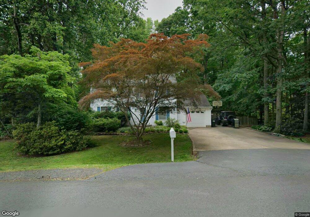
13901 Calico Ln Manassas, VA 20112
Estimated Value: $619,102 - $655,000
4
Beds
3
Baths
2,016
Sq Ft
$314/Sq Ft
Est. Value
About This Home
This home is located at 13901 Calico Ln, Manassas, VA 20112 and is currently estimated at $633,776, approximately $314 per square foot. 13901 Calico Ln is a home located in Prince William County with nearby schools including Charles J. Colgan Senior High School, Coles Elementary School, and Louise A. Benton Middle School.
Ownership History
Date
Name
Owned For
Owner Type
Purchase Details
Closed on
Sep 26, 2005
Sold by
Vaughn Ronald S
Bought by
Barnhart Peter D
Current Estimated Value
Home Financials for this Owner
Home Financials are based on the most recent Mortgage that was taken out on this home.
Original Mortgage
$310,000
Outstanding Balance
$166,762
Interest Rate
5.84%
Mortgage Type
New Conventional
Estimated Equity
$467,014
Create a Home Valuation Report for This Property
The Home Valuation Report is an in-depth analysis detailing your home's value as well as a comparison with similar homes in the area
Home Values in the Area
Average Home Value in this Area
Purchase History
| Date | Buyer | Sale Price | Title Company |
|---|---|---|---|
| Barnhart Peter D | $525,000 | -- |
Source: Public Records
Mortgage History
| Date | Status | Borrower | Loan Amount |
|---|---|---|---|
| Open | Barnhart Peter D | $310,000 |
Source: Public Records
Tax History Compared to Growth
Tax History
| Year | Tax Paid | Tax Assessment Tax Assessment Total Assessment is a certain percentage of the fair market value that is determined by local assessors to be the total taxable value of land and additions on the property. | Land | Improvement |
|---|---|---|---|---|
| 2025 | $4,744 | $495,800 | $147,400 | $348,400 |
| 2024 | $4,744 | $477,000 | $141,900 | $335,100 |
| 2023 | $4,695 | $451,200 | $134,900 | $316,300 |
| 2022 | $4,870 | $429,400 | $127,000 | $302,400 |
| 2021 | $4,770 | $389,200 | $116,800 | $272,400 |
| 2020 | $5,780 | $372,900 | $114,000 | $258,900 |
| 2019 | $5,628 | $363,100 | $112,600 | $250,500 |
| 2018 | $4,351 | $360,300 | $111,600 | $248,700 |
| 2017 | $4,415 | $356,800 | $109,800 | $247,000 |
| 2016 | $4,158 | $338,800 | $103,300 | $235,500 |
| 2015 | $4,048 | $339,200 | $102,800 | $236,400 |
| 2014 | $4,048 | $322,600 | $95,400 | $227,200 |
Source: Public Records
Map
Nearby Homes
- 8807 Doug Dr
- 14308 Bristow Rd
- Seneca Plan at Independent Hill - Independent Hill Single-Family Homes
- Lehigh Plan at Independent Hill - Independent Hill Single-Family Homes
- Hudson Plan at Independent Hill - Independent Hill Single-Family Homes
- McPherson Grand - End Unit Plan at Independent Hill - Independent Hill Townhomes
- Schubert Plan at Independent Hill - Independent Hill Townhomes
- 13437 Bristow Rd
- 14440 Independent Hill Dr
- 7800 Tayloe Dr Unit TRAILER 18
- 7800 Tayloe Dr Unit TRAILER 166
- 7800 Tayloe Dr Unit 133
- 8720 Classic Lakes Way
- 13235 Amblewood Dr
- 9101 Dawson Creek Dr
- 8701 Maple Springs Place
- 13127 White Oak Springs Place
- 13183 Rettew Dr
- 13113 White Oak Springs Place
- The Taylor Plan at The Preserve at Long Branch