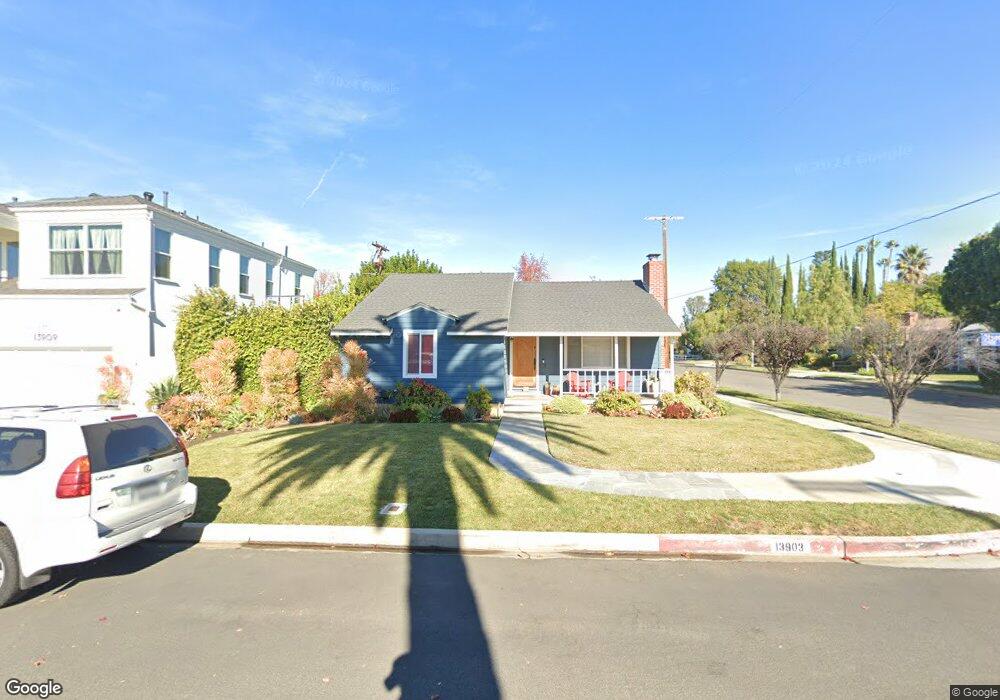
13903 Otsego St Sherman Oaks, CA 91423
Estimated Value: $1,284,027 - $1,706,000
4
Beds
2
Baths
1,657
Sq Ft
$912/Sq Ft
Est. Value
About This Home
This home is located at 13903 Otsego St, Sherman Oaks, CA 91423 and is currently estimated at $1,512,007, approximately $912 per square foot. 13903 Otsego St is a home located in Los Angeles County with nearby schools including Chandler Elementary, Ulysses S. Grant Senior High School, and Riverside Drive Charter Elementary School.
Ownership History
Date
Name
Owned For
Owner Type
Purchase Details
Closed on
Jul 17, 1998
Sold by
Romero Robert and Romero Joyce
Bought by
Kaloustian Aram and Kaloustian Tamar
Current Estimated Value
Home Financials for this Owner
Home Financials are based on the most recent Mortgage that was taken out on this home.
Original Mortgage
$227,150
Interest Rate
6.89%
Create a Home Valuation Report for This Property
The Home Valuation Report is an in-depth analysis detailing your home's value as well as a comparison with similar homes in the area
Home Values in the Area
Average Home Value in this Area
Purchase History
| Date | Buyer | Sale Price | Title Company |
|---|---|---|---|
| Kaloustian Aram | $285,000 | Equity Title |
Source: Public Records
Mortgage History
| Date | Status | Borrower | Loan Amount |
|---|---|---|---|
| Previous Owner | Kaloustian Aram | $227,150 | |
| Closed | Kaloustian Aram | $28,500 |
Source: Public Records
Tax History Compared to Growth
Tax History
| Year | Tax Paid | Tax Assessment Tax Assessment Total Assessment is a certain percentage of the fair market value that is determined by local assessors to be the total taxable value of land and additions on the property. | Land | Improvement |
|---|---|---|---|---|
| 2025 | $5,463 | $446,771 | $277,784 | $168,987 |
| 2024 | $5,463 | $438,012 | $272,338 | $165,674 |
| 2023 | $5,358 | $429,425 | $266,999 | $162,426 |
| 2022 | $5,111 | $421,006 | $261,764 | $159,242 |
| 2021 | $5,041 | $412,752 | $256,632 | $156,120 |
| 2019 | $4,891 | $400,512 | $249,021 | $151,491 |
| 2018 | $4,795 | $392,660 | $244,139 | $148,521 |
| 2016 | $4,569 | $377,413 | $234,659 | $142,754 |
| 2015 | $4,502 | $371,745 | $231,135 | $140,610 |
| 2014 | $4,522 | $364,464 | $226,608 | $137,856 |
Source: Public Records
Map
Nearby Homes
- 13845 Magnolia Blvd
- 14050 Magnolia Blvd Unit 316
- 14012 Morrison St
- 13807 Magnolia Blvd
- 14126 Hartsook St
- 13931 Margate St
- 13943 Margate St
- 13940 Chandler Blvd
- 5263 Buffalo Ave
- 4846 Katherine Ave
- 5444 Murietta Ave
- 13536 Morrison St
- 13530 Morrison St
- 13521 Magnolia Blvd
- 4915 Tyrone Ave Unit 102
- 4915 Tyrone Ave Unit 234
- 5305 Allott Ave
- 5509 Cantaloupe Ave
- 5512 Ranchito Ave
- 13627 Chandler Blvd
- 13909 Otsego St
- 13900 Hartsook St
- 13915 Otsego St
- 13908 Hartsook St
- 13902 Otsego St
- 5056 Ranchito Ave
- 5062 Ranchito Ave
- 13908 Otsego St
- 13914 Hartsook St
- 13921 Otsego St
- 5050 Ranchito Ave
- 5100 Ranchito Ave
- 13914 Otsego St
- 5042 Ranchito Ave
- 5106 Ranchito Ave
- 13920 Hartsook St
- 13920 Otsego St
- 13927 Otsego St
- 13903 Hesby St
- 13909 Hesby St