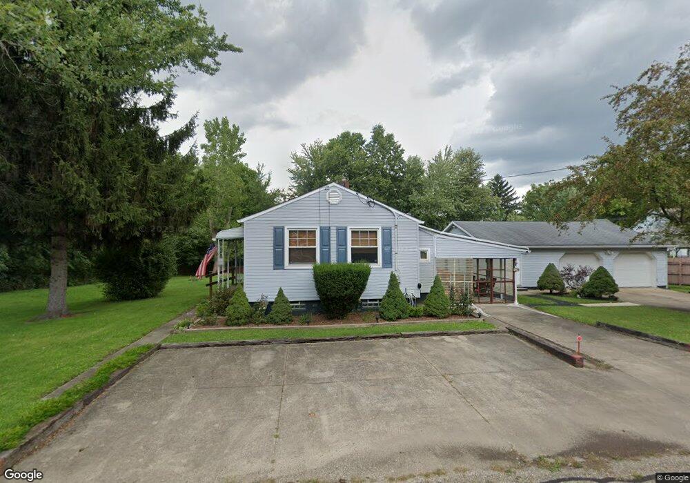
1392 Wade Ave Alliance, OH 44601
Estimated Value: $100,000 - $106,000
2
Beds
1
Bath
596
Sq Ft
$173/Sq Ft
Est. Value
About This Home
This home is located at 1392 Wade Ave, Alliance, OH 44601 and is currently estimated at $103,367, approximately $173 per square foot. 1392 Wade Ave is a home located in Stark County with nearby schools including Alliance Elementary School at Rockhill, Alliance Intermediate School at Northside, and Alliance Middle School.
Ownership History
Date
Name
Owned For
Owner Type
Purchase Details
Closed on
Dec 15, 2011
Sold by
Drake Dennis L
Bought by
Drake Dennis L and Schieben Diane M
Current Estimated Value
Purchase Details
Closed on
Jan 13, 1998
Sold by
Rhue Agnes A
Bought by
Drake Dennis L
Home Financials for this Owner
Home Financials are based on the most recent Mortgage that was taken out on this home.
Original Mortgage
$36,800
Interest Rate
7.26%
Mortgage Type
New Conventional
Purchase Details
Closed on
Jun 6, 1994
Sold by
Fraraccio John P
Bought by
Rhue Agnes A
Home Financials for this Owner
Home Financials are based on the most recent Mortgage that was taken out on this home.
Original Mortgage
$23,750
Interest Rate
8.48%
Mortgage Type
New Conventional
Create a Home Valuation Report for This Property
The Home Valuation Report is an in-depth analysis detailing your home's value as well as a comparison with similar homes in the area
Home Values in the Area
Average Home Value in this Area
Purchase History
| Date | Buyer | Sale Price | Title Company |
|---|---|---|---|
| Drake Dennis L | -- | Attorney | |
| Drake Dennis L | $44,500 | -- | |
| Rhue Agnes A | $25,000 | -- |
Source: Public Records
Mortgage History
| Date | Status | Borrower | Loan Amount |
|---|---|---|---|
| Closed | Drake Dennis L | $36,800 | |
| Previous Owner | Rhue Agnes A | $23,750 |
Source: Public Records
Tax History
| Year | Tax Paid | Tax Assessment Tax Assessment Total Assessment is a certain percentage of the fair market value that is determined by local assessors to be the total taxable value of land and additions on the property. | Land | Improvement |
|---|---|---|---|---|
| 2025 | -- | $26,920 | $5,780 | $21,140 |
| 2024 | -- | $26,920 | $5,780 | $21,140 |
| 2023 | $387 | $18,800 | $5,530 | $13,270 |
| 2022 | $407 | $18,800 | $5,530 | $13,270 |
| 2021 | $407 | $18,800 | $5,530 | $13,270 |
| 2020 | $304 | $15,760 | $4,800 | $10,960 |
| 2019 | $300 | $15,760 | $4,800 | $10,960 |
| 2018 | $301 | $15,760 | $4,800 | $10,960 |
| 2017 | $259 | $14,680 | $4,030 | $10,650 |
| 2016 | $261 | $14,680 | $4,030 | $10,650 |
| 2015 | $198 | $13,210 | $4,030 | $9,180 |
| 2014 | $155 | $12,080 | $3,680 | $8,400 |
| 2013 | $77 | $12,080 | $3,680 | $8,400 |
Source: Public Records
Map
Nearby Homes
- 1522 Wade Ave
- 834 Devine St
- 1608 S Liberty Ave
- 1350 S Freedom Ave
- 935 S Morgan Ave
- 1823 S Seneca Ave
- 955 E Summit St
- 22862 Norman Ave
- 233 Shadyside Ct
- 167 11th St
- 226 Milner St
- 231 Rosenberry St
- 234 Rosenberry St
- 452 E Summit St
- 134 11th St
- 726 S Arch Ave
- 442 S Liberty Ave
- 2041 Watson Ave
- 46 Rosenberry St
- V/L S Freedom Ave
- 1371 Woodland Ave
- 1371 Woodland Ave
- 936 Waugh St
- 1412 Wade Ave
- 1365 Woodland Ave
- 1422 Wade Ave
- 1411 Wade Ave
- 1428 Wade Ave
- 1355 Woodland Ave
- 1421 Wade Ave
- 1392 S Morgan Ave
- 1406 S Morgan Ave
- 1438 Wade Ave
- 1435 Wade Ave
- 1416 S Morgan Ave
- 1424 S Morgan Ave
- 1448 Wade Ave
- 1434 S Morgan Ave
- 1344 S Morgan Ave
- 1458 Wade Ave
Your Personal Tour Guide
Ask me questions while you tour the home.