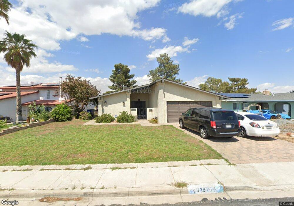
13920 Burning Tree Dr Victorville, CA 92395
Estimated Value: $372,010 - $413,000
3
Beds
2
Baths
1,628
Sq Ft
$244/Sq Ft
Est. Value
About This Home
This home is located at 13920 Burning Tree Dr, Victorville, CA 92395 and is currently estimated at $397,003, approximately $243 per square foot. 13920 Burning Tree Dr is a home located in San Bernardino County with nearby schools including Del Rey Elementary School, Green Tree East Elementary School, and Lakeview Leadership Academy.
Ownership History
Date
Name
Owned For
Owner Type
Purchase Details
Closed on
Nov 21, 2017
Sold by
Leon Abraham
Bought by
Navarro Claudia M Sanchez
Current Estimated Value
Home Financials for this Owner
Home Financials are based on the most recent Mortgage that was taken out on this home.
Original Mortgage
$216,997
Outstanding Balance
$181,351
Interest Rate
3.75%
Mortgage Type
FHA
Estimated Equity
$215,652
Create a Home Valuation Report for This Property
The Home Valuation Report is an in-depth analysis detailing your home's value as well as a comparison with similar homes in the area
Home Values in the Area
Average Home Value in this Area
Purchase History
| Date | Buyer | Sale Price | Title Company |
|---|---|---|---|
| Navarro Claudia M Sanchez | -- | First American Title Company | |
| Navarro Claudia M Sanchez | $221,000 | First American Title Company |
Source: Public Records
Mortgage History
| Date | Status | Borrower | Loan Amount |
|---|---|---|---|
| Open | Navarro Claudia M Sanchez | $216,997 |
Source: Public Records
Tax History Compared to Growth
Tax History
| Year | Tax Paid | Tax Assessment Tax Assessment Total Assessment is a certain percentage of the fair market value that is determined by local assessors to be the total taxable value of land and additions on the property. | Land | Improvement |
|---|---|---|---|---|
| 2025 | $2,960 | $251,460 | $50,292 | $201,168 |
| 2024 | $2,960 | $246,530 | $49,306 | $197,224 |
| 2023 | $2,932 | $241,696 | $48,339 | $193,357 |
| 2022 | $2,882 | $236,957 | $47,391 | $189,566 |
| 2021 | $2,830 | $232,311 | $46,462 | $185,849 |
| 2020 | $2,780 | $229,929 | $45,986 | $183,943 |
| 2019 | $2,734 | $225,420 | $45,084 | $180,336 |
| 2018 | $2,913 | $221,000 | $44,200 | $176,800 |
| 2017 | $2,236 | $174,374 | $55,483 | $118,891 |
| 2016 | $2,190 | $170,955 | $54,395 | $116,560 |
| 2015 | $2,111 | $168,387 | $53,578 | $114,809 |
| 2014 | $2,070 | $165,088 | $52,528 | $112,560 |
Source: Public Records
Map
Nearby Homes
- 13916 Burning Tree Dr
- 13925 Burning Tree Dr
- 13958 Burning Tree Dr
- 13835 Burning Tree Dr
- 13997 Wimbleton Dr
- 13951 Burning Tree Dr
- 0 Wimbleton Dr
- 0 Iron Rock Place
- 15770 Nassau Dr
- 13717 Oakmont Dr
- 15682 Kingswood Dr
- 16090 Yates Rd
- 14172 La Paz Dr
- 13671 Westwood Dr
- 14268 Burning Tree Dr
- 16253 Pebble Beach Dr
- 16272 Trinidad Dr
- 14299 La Paz Dr Unit 32
- 14299 La Paz Dr Unit 40
- 14299 La Paz Dr Unit 6
- 13924 Burning Tree Dr
- 13912 Burning Tree Dr
- 13928 Burning Tree Dr
- 13932 Burning Tree Dr
- 13908 Burning Tree Dr Unit 1
- 13908 Burning Tree Dr
- 13913 Burning Tree Dr
- 13929 Burning Tree Dr
- 13909 Burning Tree Dr
- 13931 Burning Tree Dr
- 13904 Burning Tree Dr
- 13936 Burning Tree Dr
- 13905 Burning Tree Dr
- 13900 Burning Tree Dr
- 13940 Burning Tree Dr
- 13914 Oakmont Dr
- 15863 Candlewood Dr
- 13935 Burning Tree Dr
- 13982 Smoke Tree Rd
- 13992 Smoke Tree Rd