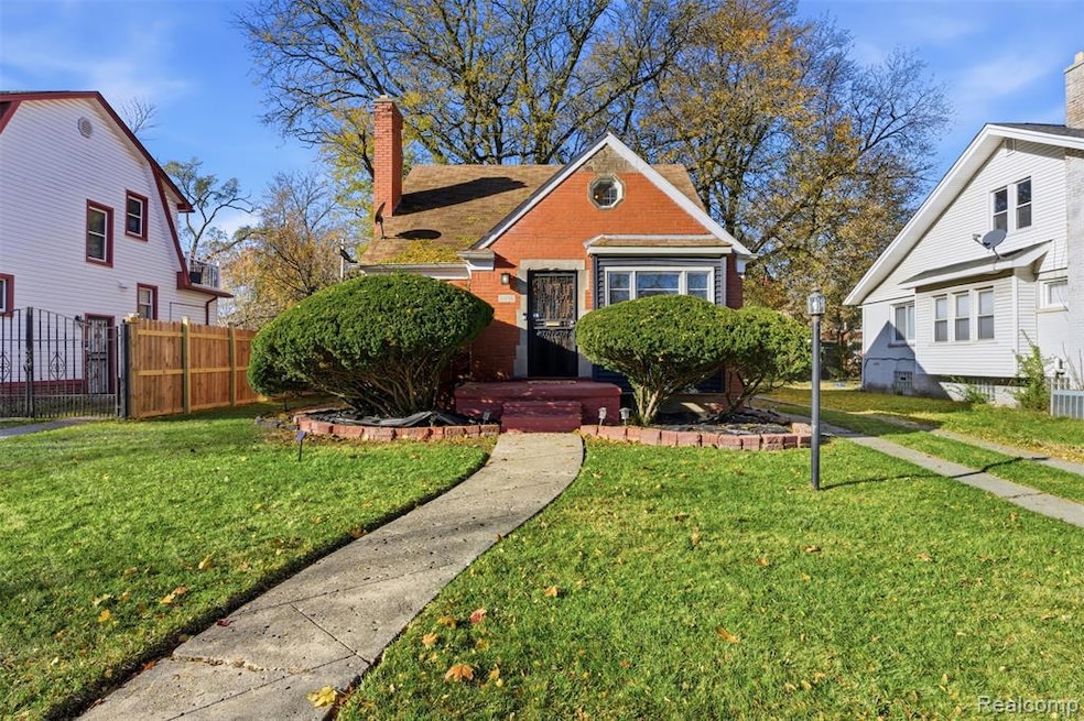
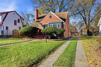
13935 Rutland St Detroit, MI 48227
Grandmont NeighborhoodEstimated payment $1,304/month
Highlights
- No HOA
- Enclosed Patio or Porch
- Fireplace
- Cass Technical High School Rated 10
- Stainless Steel Appliances
- Recessed Lighting
About This Home
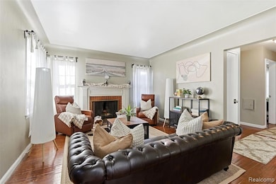
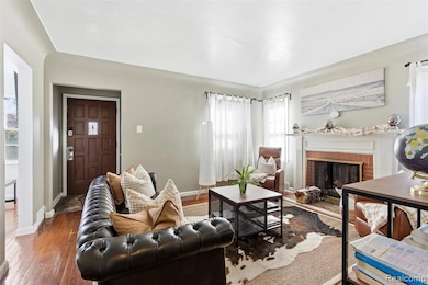
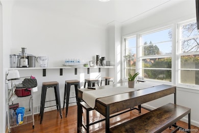
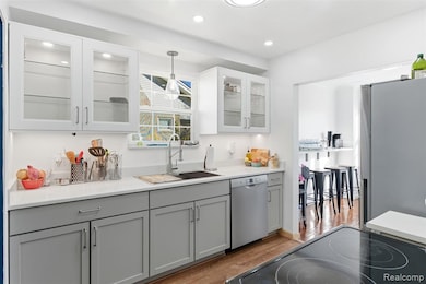
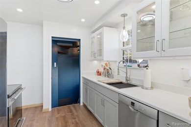
Beautifully updated 3-bedroom bungalow in the highly sought-after Grandmont Subdivision—perfect for the holidays! Step into a warm, inviting living room featuring a cozy natural fireplace. Enjoy major updates inside and out, including a fully renovated kitchen with quartz countertops, new double sink with sprayer, new upper and lower cabinetry, in-cabinet lighting, under-cabinet lighting, stainless steel dishwasher, and a new garbage disposal. Also an updated nook/dining area with stylish quartz bar counter. Modern lighting + new flooring throughout. Home features brand-new electrical panel & new wiring, new freshwater lines, new drain lines, and a new hot water tank. Bathroom is completely remodeled with marble tile, rain shower system, new vanity, new toilet + updated lighting and modern finishes. Upper-level primary bedroom includes new flooring for a warm welcoming retreat. Gorgeous custom wood beams installed throughout and refinished stairs.
Exterior highlights include an updated sun porch, fresh paint, new recessed lights, new siding around the front window bump-out, new exterior lights installed around the property, new fencing, new mulch/rock beds with spotlights, and new security gates.
Move-in ready with beautiful renovations throughout. Your perfect Grandmont home awaits!
Home Details
Home Type
- Single Family
Est. Annual Taxes
Year Built
- Built in 1950
Lot Details
- 7,405 Sq Ft Lot
- Lot Dimensions are 50x150
Home Design
- Bungalow
- Brick Exterior Construction
- Block Foundation
Interior Spaces
- 1,068 Sq Ft Home
- 1.5-Story Property
- Recessed Lighting
- Fireplace
- Stainless Steel Appliances
- Unfinished Basement
Bedrooms and Bathrooms
- 3 Bedrooms
- 1 Full Bathroom
Utilities
- Forced Air Heating System
- Heating System Uses Natural Gas
- Sewer in Street
Additional Features
- Enclosed Patio or Porch
- Ground Level
Community Details
- No Home Owners Association
- Grandmont Subdivision
Listing and Financial Details
- Assessor Parcel Number W22I068886S
Map
Home Values in the Area
Average Home Value in this Area
Tax History
| Year | Tax Paid | Tax Assessment Tax Assessment Total Assessment is a certain percentage of the fair market value that is determined by local assessors to be the total taxable value of land and additions on the property. | Land | Improvement |
|---|---|---|---|---|
| 2025 | $1,338 | $65,400 | $0 | $0 |
| 2024 | $1,338 | $54,500 | $0 | $0 |
| 2023 | $1,297 | $43,500 | $0 | $0 |
| 2022 | $1,423 | $39,000 | $0 | $0 |
| 2021 | $1,386 | $26,700 | $0 | $0 |
| 2020 | $1,371 | $22,600 | $0 | $0 |
| 2019 | $1,350 | $18,200 | $0 | $0 |
| 2018 | $1,147 | $16,900 | $0 | $0 |
| 2017 | $286 | $15,100 | $0 | $0 |
| 2016 | $1,769 | $25,400 | $0 | $0 |
| 2015 | $2,540 | $25,400 | $0 | $0 |
| 2013 | $3,178 | $31,778 | $0 | $0 |
| 2010 | -- | $44,107 | $1,393 | $42,714 |
Property History
| Date | Event | Price | List to Sale | Price per Sq Ft |
|---|---|---|---|---|
| 11/18/2025 11/18/25 | For Sale | $225,000 | -- | $211 / Sq Ft |
Purchase History
| Date | Type | Sale Price | Title Company |
|---|---|---|---|
| Interfamily Deed Transfer | -- | None Available | |
| Quit Claim Deed | $6,328 | None Available |
Source: Realcomp
MLS Number: 20251055040
APN: 22-068886
Disclaimer: Certain information contained herein is derived from information provided by parties other than Homes.com. All information provided is deemed reliable, but is not guaranteed to be accurate and should be independently verified.
![]() IDX provided courtesy of Realcomp II Ltd. via Ten-X and MLS
IDX provided courtesy of Realcomp II Ltd. via Ten-X and MLS
Copyright 2025 Realcomp II Ltd. Shareholders
IDX information is provided exclusively for consumers' personal, noncommercial use and may not be used for any purpose other than to identify prospective properties consumers may be interested in purchasing. The accuracy of all information, regardless of source, is not guaranteed or warranted. All information should be independently verified.
Listing Information presented by local MLS brokerage: Ten-X, local REALTOR®- Arlene Richardson - (888)-952-6393
- 13936 Longacre St
- 13597 Rutland St
- 14047 Longacre St
- 13566 Longacre St
- 14006 Southfield Fwy
- 13618 Grandmont Ave
- 14046 Southfield Rd
- 12912 Longacre St
- 13539 Woodmont Ave
- 13610 Woodmont Ave
- 13551 Asbury Park
- 14040 Asbury Park
- 14341 Abington Ave
- 13503 Ashton Rd
- 13609 Rosemont Ave
- 13930 Penrod St
- 14364 Rutland St
- 13538 Penrod St
- 13501 Mettetal St
- 13985 Saint Marys St
- 13621 Ashton Rd
- 13538 Rosemont Ave
- 13992 Penrod St
- 13500 Penrod St
- 12635 Memorial St
- 13514 Stahelin Rd
- 14027 Montrose St
- 14732 Woodmont Ave
- 14771 Woodmont Ave
- 14024 Grandville Ave
- 13978 Coyle St
- 12044 Forrer St
- 12690 Coyle St
- 15041 Greenfield Rd
- 15328 Prevost St
- 14613 Coyle St
- 15097-15101 Greenfield Rd
- 15111 Greenfield Rd
- 14828 Sussex St
- 15751 Asbury Park
