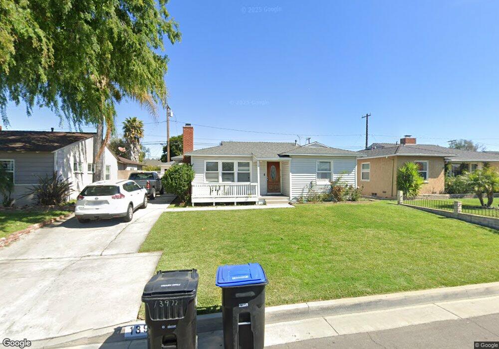
13977 Lanning Dr Whittier, CA 90605
South Whittier NeighborhoodEstimated Value: $782,220 - $807,000
2
Beds
1
Bath
1,369
Sq Ft
$579/Sq Ft
Est. Value
About This Home
This home is located at 13977 Lanning Dr, Whittier, CA 90605 and is currently estimated at $792,305, approximately $578 per square foot. 13977 Lanning Dr is a home located in Los Angeles County with nearby schools including Mulberry Elementary School, Hillview Middle School, and California High School.
Ownership History
Date
Name
Owned For
Owner Type
Purchase Details
Closed on
Jun 13, 2008
Sold by
Garcia Gerardo
Bought by
Garcia Gerardo
Current Estimated Value
Purchase Details
Closed on
Sep 4, 2003
Sold by
Wilson Louis Lee and Wilson Mary K
Bought by
Garcia Gerardo
Home Financials for this Owner
Home Financials are based on the most recent Mortgage that was taken out on this home.
Original Mortgage
$274,689
Interest Rate
5.98%
Mortgage Type
FHA
Create a Home Valuation Report for This Property
The Home Valuation Report is an in-depth analysis detailing your home's value as well as a comparison with similar homes in the area
Home Values in the Area
Average Home Value in this Area
Purchase History
| Date | Buyer | Sale Price | Title Company |
|---|---|---|---|
| Garcia Gerardo | -- | None Available | |
| Garcia Gerardo | $279,000 | -- |
Source: Public Records
Mortgage History
| Date | Status | Borrower | Loan Amount |
|---|---|---|---|
| Previous Owner | Garcia Gerardo | $274,689 | |
| Closed | Garcia Gerardo | $8,370 |
Source: Public Records
Tax History
| Year | Tax Paid | Tax Assessment Tax Assessment Total Assessment is a certain percentage of the fair market value that is determined by local assessors to be the total taxable value of land and additions on the property. | Land | Improvement |
|---|---|---|---|---|
| 2025 | $4,837 | $396,659 | $308,376 | $88,283 |
| 2024 | $4,837 | $388,882 | $302,330 | $86,552 |
| 2023 | $4,754 | $381,257 | $296,402 | $84,855 |
| 2022 | $4,649 | $373,783 | $290,591 | $83,192 |
| 2021 | $4,556 | $366,455 | $284,894 | $81,561 |
| 2019 | $4,463 | $355,588 | $276,445 | $79,143 |
| 2018 | $4,312 | $348,617 | $271,025 | $77,592 |
| 2016 | $4,079 | $335,081 | $260,501 | $74,580 |
| 2015 | $4,052 | $330,049 | $256,589 | $73,460 |
| 2014 | $3,996 | $323,585 | $251,563 | $72,022 |
Source: Public Records
Map
Nearby Homes
- 13840 Danbrook Dr
- 13856 Mulberry Dr
- 13649 Lanning Dr
- 9308 Tarryton Ave
- 9834 Ahmann Ave
- 10035 Ben Hur Ave
- 8901 Ocean View Ave
- 9344 Firebird Ave
- 10044 Ben Hur Ave
- 9931 Rufus Ave
- 14021 Fernview St
- 8847 Ocean View Ave
- 14351 Starbuck St
- 9551 Barkerville Ave
- 13814 Mystic St
- 13563 Carnell St
- 13448 Dunton Dr
- 13924 Anola St
- 14255 Broadway
- 10202 Mina Ave
- 13983 Lanning Dr
- 13973 Lanning Dr
- 14003 Lanning Dr
- 13967 Lanning Dr
- 13974 Lanning Dr
- 14009 Lanning Dr
- 13961 Lanning Dr
- 13980 Lanning Dr
- 13968 Lanning Dr
- 14002 Lanning Dr
- 14034 Danbrook Dr
- 14028 Danbrook Dr
- 14038 Danbrook Dr
- 13960 Lanning Dr
- 14015 Lanning Dr
- 14022 Danbrook Dr
- 14008 Lanning Dr
- 14044 Danbrook Dr
- 13957 Lanning Dr
- 14018 Danbrook Dr
Your Personal Tour Guide
Ask me questions while you tour the home.