
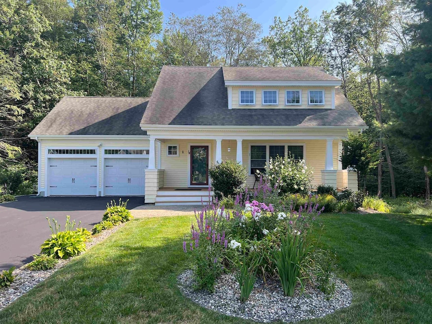
14 Coleman Ct Seabrook, NH 03874
Estimated payment $5,007/month
Total Views
5,433
3
Beds
2.5
Baths
2,155
Sq Ft
$380
Price per Sq Ft
Highlights
- Hot Property
- Deck
- 2 Car Direct Access Garage
- Craftsman Architecture
- Wood Flooring
- Walk-In Closet
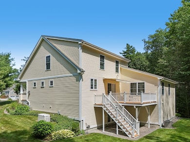
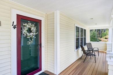
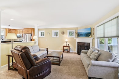
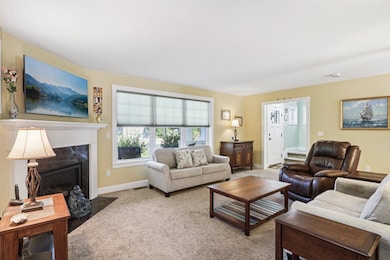
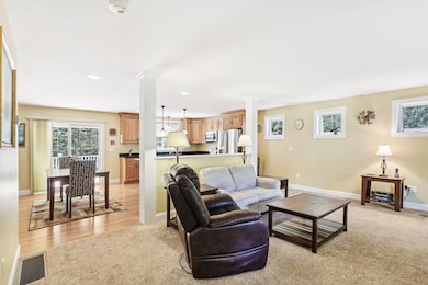
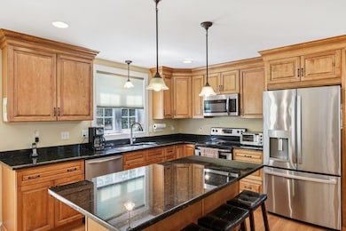
About This Home
It was worth the wait! This Beckman Woods beauty sits on a cul de sac lot abutting conservation land. The house design is one of the favorites with the welcoming front porch, first floor primary suite, attached two stall garage and an AMAZING walk out lower level ready for new owners to do as they wish. Second level has 2 generous sized bedrooms, full bath and unfinished space over the garage. Original owner has taken exception care of the property. Beckman Woods is Seabrook's hidden treasure. You will love sitting on the front porch feeling the ocean breeze and smelling the salt air. Open Houses Saturday 11-1pm and Sunday 11-1pm
Home Details
Home Type
- Single Family
Est. Annual Taxes
- $8,234
Year Built
- Built in 2012
Lot Details
- 0.43 Acre Lot
- Level Lot
- Property is zoned 91
Parking
- 2 Car Direct Access Garage
- Automatic Garage Door Opener
Home Design
- Craftsman Architecture
- Vinyl Siding
Interior Spaces
- Property has 2 Levels
- Entrance Foyer
- Living Room
- Carbon Monoxide Detectors
Kitchen
- Microwave
- Dishwasher
- Kitchen Island
Flooring
- Wood
- Carpet
- Vinyl
Bedrooms and Bathrooms
- 3 Bedrooms
- En-Suite Bathroom
- Walk-In Closet
Laundry
- Laundry Room
- Dryer
- Washer
Basement
- Walk-Out Basement
- Basement Fills Entire Space Under The House
Outdoor Features
- Deck
Schools
- Seabrook Elementary School
- Seabrook Middle School
- Winnacunnet High School
Utilities
- Forced Air Heating and Cooling System
- Underground Utilities
Listing and Financial Details
- Legal Lot and Block 40 / 54
- Assessor Parcel Number 13
Community Details
Overview
- Beckman Woods Subdivision
Recreation
- Trails
Map
Create a Home Valuation Report for This Property
The Home Valuation Report is an in-depth analysis detailing your home's value as well as a comparison with similar homes in the area
Home Values in the Area
Average Home Value in this Area
Tax History
| Year | Tax Paid | Tax Assessment Tax Assessment Total Assessment is a certain percentage of the fair market value that is determined by local assessors to be the total taxable value of land and additions on the property. | Land | Improvement |
|---|---|---|---|---|
| 2024 | $8,234 | $702,600 | $322,100 | $380,500 |
| 2023 | $7,927 | $525,300 | $234,200 | $291,100 |
| 2022 | $6,960 | $525,300 | $234,200 | $291,100 |
| 2021 | $7,212 | $525,300 | $234,200 | $291,100 |
| 2020 | $6,902 | $432,200 | $187,400 | $244,800 |
| 2019 | $6,807 | $432,200 | $187,400 | $244,800 |
| 2018 | $6,897 | $424,400 | $166,100 | $258,300 |
| 2017 | $6,448 | $396,800 | $138,500 | $258,300 |
| 2016 | $5,869 | $396,800 | $138,500 | $258,300 |
| 2015 | $5,492 | $371,300 | $129,900 | $241,400 |
| 2014 | $5,670 | $371,300 | $129,900 | $241,400 |
| 2013 | $5,670 | $371,300 | $129,900 | $241,400 |
Source: Public Records
Property History
| Date | Event | Price | List to Sale | Price per Sq Ft |
|---|---|---|---|---|
| 11/12/2025 11/12/25 | For Sale | $819,900 | -- | $380 / Sq Ft |
Source: PrimeMLS
Purchase History
| Date | Type | Sale Price | Title Company |
|---|---|---|---|
| Warranty Deed | -- | None Available | |
| Warranty Deed | -- | None Available | |
| Warranty Deed | $388,400 | -- | |
| Warranty Deed | $388,400 | -- |
Source: Public Records
Mortgage History
| Date | Status | Loan Amount | Loan Type |
|---|---|---|---|
| Closed | $0 | No Value Available |
Source: Public Records
About the Listing Agent
As a recognized leader in New Hampshire real estate, Andrea Marie Delahunty is known for professionalism, expertise and integrity. With over 20 years of experience, Andrea is driven to exceed expectations and provide exceptional results while representing her client's best interest.
Every person’s real estate goals are different, and no two transactions are the same. With this in mind, Andrea creates a tailored plan and strategy catered to each client. Unparalleled marketing, world-class
Andrea's Other Listings
Source: PrimeMLS
MLS Number: 5069293
APN: SEAB-000013-000054-000040
Disclaimer: Certain information contained herein is derived from information provided by parties other than Homes.com. All information provided is deemed reliable, but is not guaranteed to be accurate and should be independently verified.
![]() Copyright 2025 PrimeMLS, Inc. All rights reserved. This information is deemed reliable, but not guaranteed. The data relating to real estate displayed on this display comes in part from the IDX Program of PrimeMLS. The information being provided is for consumers’ personal, non-commercial use and may not be used for any purpose other than to identify prospective properties consumers may be interested in purchasing.
Copyright 2025 PrimeMLS, Inc. All rights reserved. This information is deemed reliable, but not guaranteed. The data relating to real estate displayed on this display comes in part from the IDX Program of PrimeMLS. The information being provided is for consumers’ personal, non-commercial use and may not be used for any purpose other than to identify prospective properties consumers may be interested in purchasing.
Nearby Homes
- 8 Kimberly Dr
- 22 Farm Ln
- 176 Lower Collins St
- 57 Washington St
- 35 Norman Rd
- 19 Fowlers Ct
- 1 Old Salt Dr
- 20 Railroad Ave
- 28 Brooks Rd
- 38 Rocks Rd Unit 2
- 38 Rocks Rd Unit 1
- 241 & 245 Lafayette Rd
- 2 Collins St
- 312 S Main St
- 27 Cross Beach Rd
- 308 Route 286 Unit 77
- 308 Route 286 Unit Lot 58
- 81 Elm Ct
- 18 River St
- 188 Lafayette Rd
- 34 Brooks Rd
- 2 Autumn Way
- 689 Lafayette Rd
- 14 New Zealand Rd Unit 6
- 44 New Zealand Rd
- 296 Ocean Blvd
- 226 Ocean Blvd
- 18 Lowell St Unit Up
- 38 Brimmer Ln Unit A
- 131 Franklin St
- 116 Cimarron Dr
- 301 Portsmouth Ave Unit ID1312414P
- 301 Portsmouth Ave Unit ID1312408P
- 301 Portsmouth Ave Unit ID1312392P
- 301 Portsmouth Ave Unit ID1312402P
- 301 Portsmouth Ave Unit 2
- 301 Portsmouth Ave Unit 3
- 170 Tilton St
- 352 Portsmouth Ave
- 136 Franklin St Unit Back