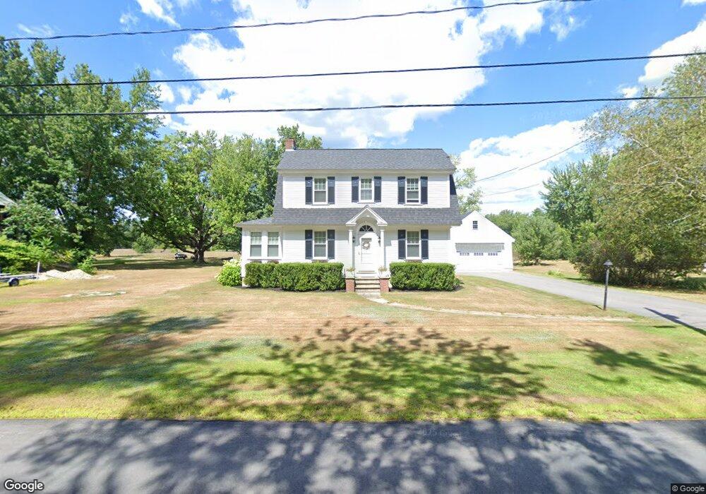
14 Covered Bridge Rd Ossipee, NH 03864
Estimated Value: $335,770 - $469,000
3
Beds
2
Baths
2,057
Sq Ft
$200/Sq Ft
Est. Value
About This Home
This home is located at 14 Covered Bridge Rd, Ossipee, NH 03864 and is currently estimated at $411,193, approximately $199 per square foot. 14 Covered Bridge Rd is a home with nearby schools including Ossipee Central School, Kingswood Regional Middle School, and Kingswood Regional High School.
Ownership History
Date
Name
Owned For
Owner Type
Purchase Details
Closed on
Jul 2, 2013
Sold by
Higgins Kevin G and Higgins Nancy L
Bought by
Lord Lindsay E
Current Estimated Value
Purchase Details
Closed on
Jan 28, 2010
Sold by
Fhlmc
Bought by
Higgins Kevin G and Higgins Nancy L
Purchase Details
Closed on
Aug 4, 2009
Sold by
Plante Ronald A
Bought by
Northeast Credit Union
Purchase Details
Closed on
Sep 21, 2004
Sold by
Kelley Robert E
Bought by
Plante Ronald A and Plante Jennifer L
Home Financials for this Owner
Home Financials are based on the most recent Mortgage that was taken out on this home.
Original Mortgage
$161,400
Interest Rate
6.02%
Mortgage Type
Purchase Money Mortgage
Create a Home Valuation Report for This Property
The Home Valuation Report is an in-depth analysis detailing your home's value as well as a comparison with similar homes in the area
Home Values in the Area
Average Home Value in this Area
Purchase History
| Date | Buyer | Sale Price | Title Company |
|---|---|---|---|
| Lord Lindsay E | $165,500 | -- | |
| Lord Lindsay E | $165,500 | -- | |
| Higgins Kevin G | $90,000 | -- | |
| Fhlmc | $75,200 | -- | |
| Fhlmc | $75,200 | -- | |
| Northeast Credit Union | $150,300 | -- | |
| Northeast Credit Union | $150,300 | -- | |
| Plante Ronald A | $169,900 | -- | |
| Plante Ronald A | $169,900 | -- |
Source: Public Records
Mortgage History
| Date | Status | Borrower | Loan Amount |
|---|---|---|---|
| Previous Owner | Plante Ronald A | $161,400 | |
| Closed | Plante Ronald A | $0 |
Source: Public Records
Tax History
| Year | Tax Paid | Tax Assessment Tax Assessment Total Assessment is a certain percentage of the fair market value that is determined by local assessors to be the total taxable value of land and additions on the property. | Land | Improvement |
|---|---|---|---|---|
| 2024 | $4,833 | $416,600 | $136,000 | $280,600 |
| 2023 | $4,320 | $416,600 | $136,000 | $280,600 |
| 2022 | $3,560 | $193,700 | $28,600 | $165,100 |
| 2021 | $3,551 | $193,700 | $28,600 | $165,100 |
| 2020 | $3,291 | $193,000 | $28,600 | $164,400 |
| 2019 | $3,001 | $175,400 | $28,600 | $146,800 |
| 2018 | $5,157 | $160,900 | $22,600 | $138,300 |
| 2016 | $3,044 | $157,700 | $22,600 | $135,100 |
| 2015 | $2,891 | $157,700 | $22,600 | $135,100 |
| 2014 | $3,094 | $171,700 | $30,600 | $141,100 |
| 2013 | $2,476 | $142,400 | $30,600 | $111,800 |
Source: Public Records
Map
Nearby Homes
- 1785 White Mountain Hwy
- 23 Poco Dr
- 48 South Way
- 68 & 00 Gilman Valley & Route 25 W
- 00 Route 25 W Unit tbd
- 68 Gilman Valley Rd
- Lot 18.1 White Mountain Hwy
- 24 Flynn Ln
- 78 Berry Ln
- Map 206 Lot 28 Whittier Rd
- 156 Fawn Dr
- 5 Whittier Rd
- 1800 Route 16
- 190 Whittier Rd
- 498 Whittier Rd
- Lot 56-3 Ossipee Mountain Rd
- 96 Bryant Mill Rd
- 527 Tamworth Rd
- 31 Pinder Mill Rd
- 269 Tamworth Rd
- 10 Covered Bridge Rd
- 16 Covered Bridge Rd
- 14 Covered Bridge Rd
- 8 Covered Bridge Rd
- 10 Covered Bridge Rd
- 20 Covered Bridge Rd
- 4 Covered Bridge Rd
- 2 Covered Bridge Rd
- 2 Covered Bridge Rd
- 10 Route 16 and Route 41
- 2420 NE Route 16
- 3 Covered Bridge Rd
- 10 New Hampshire 41
- 2055 W Ossipee Nh 03890 Route
- 2055 Nh Route 16 Ave Unit 1
- 30 Grizzley Rd
- 2400 Route 16
- 20 Route 41
- RT. New Hampshire 41
- 7 Depot Square St
Your Personal Tour Guide
Ask me questions while you tour the home.