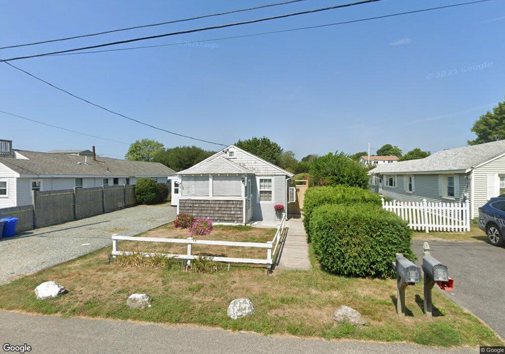
14 Defelice Rd Narragansett, RI 02882
Estimated Value: $492,000 - $566,000
2
Beds
1
Bath
600
Sq Ft
$856/Sq Ft
Est. Value
About This Home
This home is located at 14 Defelice Rd, Narragansett, RI 02882 and is currently estimated at $513,550, approximately $855 per square foot. 14 Defelice Rd is a home located in Washington County with nearby schools including Narragansett Elementary School, Narragansett Pier Middle School, and Narragansett High School.
Ownership History
Date
Name
Owned For
Owner Type
Purchase Details
Closed on
Aug 31, 2017
Sold by
Shirley Glenn T and Shirley Ann M
Bought by
Shirley Glenn T and Shirley Ann M
Current Estimated Value
Purchase Details
Closed on
Apr 10, 2017
Sold by
Shirley Ann M and Ursillo Joseph F
Bought by
Shirley Ann M
Purchase Details
Closed on
Jan 11, 2016
Sold by
Shirley Ann M and Ursillo Joseph F
Bought by
Shirley Ann M
Purchase Details
Closed on
May 6, 2014
Sold by
Ursillo Anthony
Bought by
Ursillo Joseph F
Create a Home Valuation Report for This Property
The Home Valuation Report is an in-depth analysis detailing your home's value as well as a comparison with similar homes in the area
Home Values in the Area
Average Home Value in this Area
Purchase History
| Date | Buyer | Sale Price | Title Company |
|---|---|---|---|
| Shirley Glenn T | -- | -- | |
| Shirley Ann M | -- | -- | |
| Shirley Ann M | -- | -- | |
| Shirley Ann M | -- | -- | |
| Ursillo Joseph F | -- | -- | |
| Joseph F Ursillo T | -- | -- |
Source: Public Records
Tax History Compared to Growth
Tax History
| Year | Tax Paid | Tax Assessment Tax Assessment Total Assessment is a certain percentage of the fair market value that is determined by local assessors to be the total taxable value of land and additions on the property. | Land | Improvement |
|---|---|---|---|---|
| 2024 | $2,528 | $385,900 | $262,600 | $123,300 |
| 2023 | $2,473 | $265,600 | $187,600 | $78,000 |
| 2022 | $2,390 | $265,600 | $187,600 | $78,000 |
| 2021 | $2,353 | $265,600 | $187,600 | $78,000 |
| 2020 | $2,425 | $231,400 | $187,600 | $43,800 |
| 2019 | $2,367 | $231,400 | $187,600 | $43,800 |
| 2018 | $2,302 | $231,400 | $187,600 | $43,800 |
| 2017 | $2,172 | $205,700 | $176,000 | $29,700 |
| 2016 | $2,073 | $205,700 | $176,000 | $29,700 |
| 2015 | $2,045 | $205,700 | $176,000 | $29,700 |
| 2014 | $2,496 | $248,600 | $199,500 | $49,100 |
Source: Public Records
Map
Nearby Homes
- 64 Burnside Ave
- 41 Fox Dr
- 16 Newport Ln
- 27 Foster Ln
- 660 Point Judith Rd Unit D2
- 8 Knowlesway
- 576 Point Judith Rd
- 45 Durkin Dr
- 1044 Ocean Rd
- 1046 Ocean Rd
- 0 Daytona Ave
- 31 E Pond Rd
- 101 Kenyon Farm Rd
- 17 Goose Island Rd
- 20 Marine Dr
- 0 Houston Ave
- 6 Pendleton Place
- 147 Foddering Farm Rd
- 2 Blindbrook Dr
- 1125 Point Judith Rd Unit B6