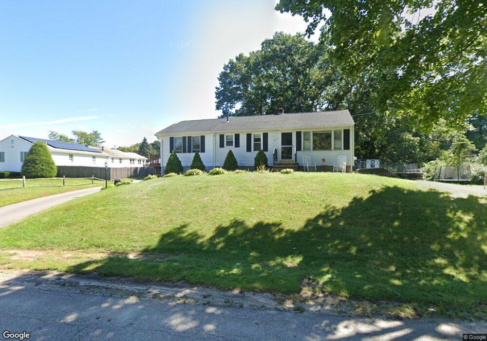
14 Dunn Ave Wrentham, MA 02093
Estimated Value: $492,881 - $548,000
2
Beds
1
Bath
1,120
Sq Ft
$468/Sq Ft
Est. Value
About This Home
This home is located at 14 Dunn Ave, Wrentham, MA 02093 and is currently estimated at $524,720, approximately $468 per square foot. 14 Dunn Ave is a home located in Norfolk County with nearby schools including Delaney Elementary School, Charles E Roderick, and Discovery Daycare Center.
Ownership History
Date
Name
Owned For
Owner Type
Purchase Details
Closed on
May 13, 2005
Sold by
Baccari Kerri A and Vachon Kerri A
Bought by
Thompson Kerri A and Thompson Robert C
Current Estimated Value
Home Financials for this Owner
Home Financials are based on the most recent Mortgage that was taken out on this home.
Original Mortgage
$240,000
Outstanding Balance
$126,821
Interest Rate
6.05%
Mortgage Type
Purchase Money Mortgage
Estimated Equity
$397,899
Purchase Details
Closed on
Sep 30, 1999
Sold by
Major George A and Major Susan E
Bought by
Vachon Kerri A
Home Financials for this Owner
Home Financials are based on the most recent Mortgage that was taken out on this home.
Original Mortgage
$131,600
Interest Rate
7.85%
Mortgage Type
Purchase Money Mortgage
Create a Home Valuation Report for This Property
The Home Valuation Report is an in-depth analysis detailing your home's value as well as a comparison with similar homes in the area
Purchase History
| Date | Buyer | Sale Price | Title Company |
|---|---|---|---|
| Thompson Kerri A | $300,000 | -- | |
| Vachon Kerri A | $154,900 | -- |
Source: Public Records
Mortgage History
| Date | Status | Borrower | Loan Amount |
|---|---|---|---|
| Open | Thompson Kerri A | $240,000 | |
| Closed | Thompson Kerri A | $60,000 | |
| Previous Owner | Vachon Kerri A | $131,600 | |
| Previous Owner | Vachon Kerri A | $69,000 |
Source: Public Records
Tax History
| Year | Tax Paid | Tax Assessment Tax Assessment Total Assessment is a certain percentage of the fair market value that is determined by local assessors to be the total taxable value of land and additions on the property. | Land | Improvement |
|---|---|---|---|---|
| 2025 | $5,331 | $460,000 | $268,100 | $191,900 |
| 2024 | $4,931 | $410,900 | $268,100 | $142,800 |
| 2023 | $4,630 | $366,900 | $243,700 | $123,200 |
| 2022 | $4,652 | $340,300 | $227,400 | $112,900 |
| 2021 | $4,304 | $305,900 | $198,500 | $107,400 |
| 2020 | $4,066 | $285,300 | $176,500 | $108,800 |
| 2019 | $4,002 | $283,400 | $176,500 | $106,900 |
| 2018 | $4,048 | $284,300 | $176,600 | $107,700 |
| 2017 | $3,860 | $270,900 | $173,200 | $97,700 |
| 2016 | $3,770 | $264,000 | $168,200 | $95,800 |
| 2015 | $3,643 | $243,200 | $161,700 | $81,500 |
| 2014 | $3,583 | $234,000 | $155,500 | $78,500 |
Source: Public Records
Map
Nearby Homes
- 282 Thurston St
- 483 Thurston St
- 10 Nature View Dr
- 15 Nature View Dr
- 576 Dedham St
- 25 Foxboro Rd
- 131 Washington St Unit 50
- 8 Conway Ln
- 75 Foxboro Rd
- 12 Goodwin Dr
- 1 Weber Farm Rd Unit 1
- 3 Earle Stewart Ln
- 135 Creek St Unit 2
- 2 Earle Stewart Ln
- 10 Earle Stewart Ln Unit Lot 5
- 12 Earle Stewart Ln
- 11 Weber Farm Rd Unit 11
- 8 Weber Farm Rd Unit 8
- 30 Weber Farm Rd Unit 30
- 9 Sharon Ave
Your Personal Tour Guide
Ask me questions while you tour the home.